Touring the geologic map of the United States
Published in 1974 by the US Geological Survey, the geologic map of the United States beautifully lays out our country’s geology. If you’re stuck at home these days –as most of us are—you can gaze at this masterpiece and go anywhere! 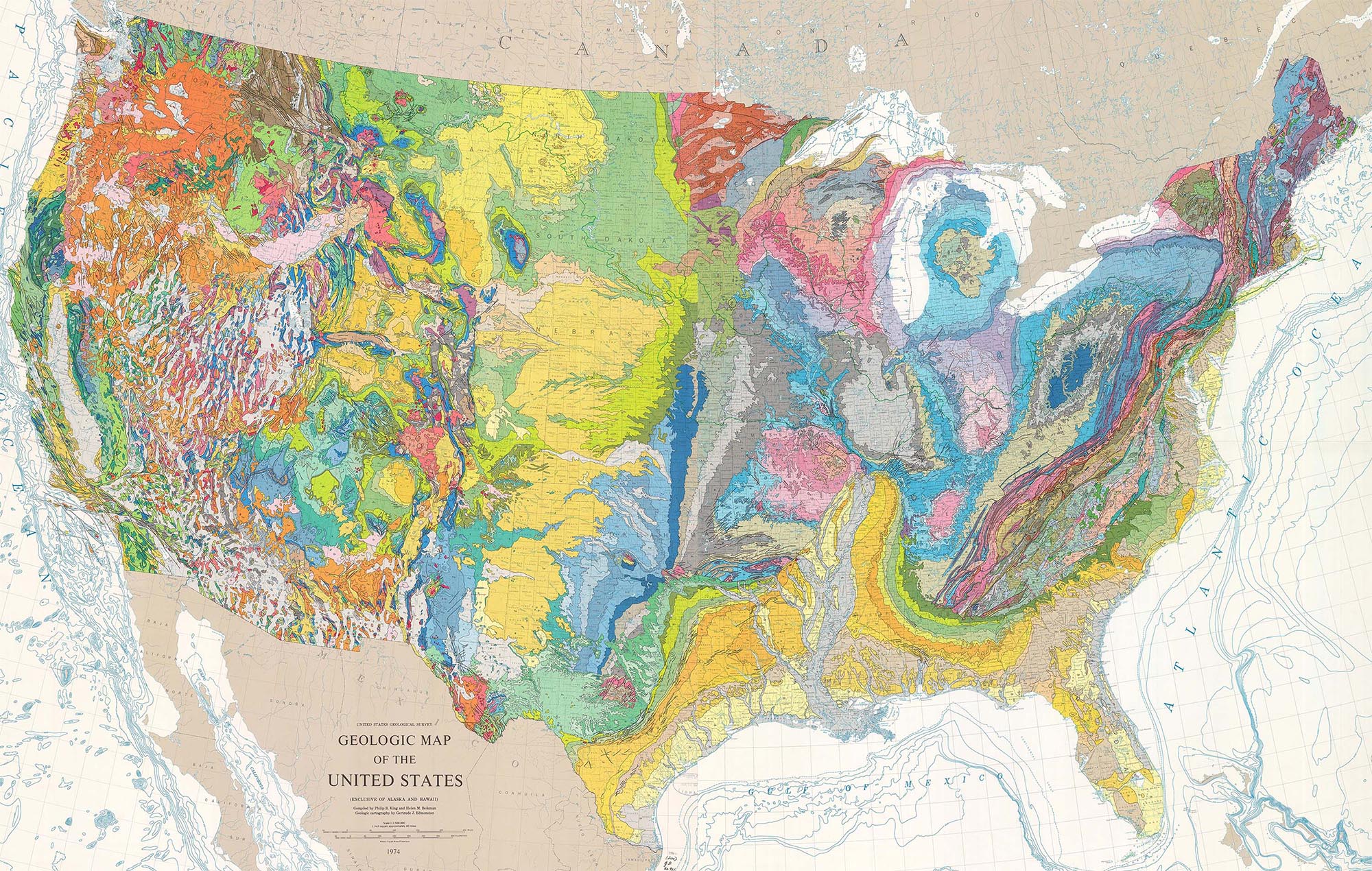
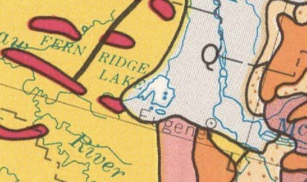
Southern Willamette Valley. Eugene’s in the center of the map
At their simplest, geologic maps read like road maps: they tell you what rock unit or recent deposit forms the ground at a given place. So right here where I am in Eugene, Oregon, I can see that I live on “Q” –which stretches north up the Willamette Valley. “Q” stands for Quaternary-age material (2.5 million years to present), which is typically alluvial material –or sediment deposited by rivers and streams. Just to the south of me lie a variety of older volcanic and sedimentary rocks. You can look them up in the map’s legend using their symbols. Here’s Rule #0: white areas, being mostly alluvium, mark low areas; colorful areas indicate bedrock, so are typically higher in elevation.
The beauty of this map is that you can see the whole country at once, and using just a few rules, can immediately glean the underlying structure of a region.For any of the maps, photos, and diagrams here, you can see a larger size if you click on the image.

Rule 1: Rock bodies without internal contacts appear as color swatches (or “blobs”) as seen on the block diagram below. These rocks include intrusive igneous, undifferentiated metamorphic, and flat-lying sedimentary rock. (If you’re not sure what geologic contacts are, please see my recent post on the nature of geologic contacts.)
Rule 2: Rock bodies with internal contacts appear as stripes, which you can see from the diagram above and the photos below. These rocks are typically inclined sedimentary rocks –simply because the contacts between different rock units appear as lines where they intersect the Earth’s surface. And notice that the steeper the rocks dip (their angle of inclination), the narrower the stripe becomes. In fact, the outcrop widths of vertically dipping beds equals their thickness!

Aerial view of tilted Paleozoic-Mesozoic sedimentary rock at the edge of the Front Range, Colorado
Rule 3. You really can read a map like a cross-section –in fact, maps are basically the same things as cross-sections except they represent horizontal slices of the crust rather than vertical ones. As an example, you get an incomplete geologic history if you only use the cross-section in the block diagram above. The map view actually has all the information because it not only depicts the fold in map view, but also the fault.
Rule 4. Folded rocks typically appear on maps as zig-zags, or in the case of the single anticline in the block diagram above, as a half zig-zag. You get a full zig-zag if you have a paired anticline and syncline, like in the diagram below. The map expression results from the hinge of the fold being inclined –or plunging—rather than simply being horizontal. 
And here’s an air photo of a plunging fold in the Montana Fold-Thrust Belt.

Aerial view of north-plunging anticline in the Fold-Thrust Belt of SW Montana

Geologic Time Scale. If you don’t know the geologic time scale, click on the image to the side to see it at full size (like all the images here). As far as reading geologic maps, it’s very helpful to know the time scale and the abbreviations of the different time periods. So, “X, W, Y, Z” are all Precambrian (X=Archean; W, Y, Z=progressively younger Proterozoic); “Pz” means Paleozoic (541-252 million years ago), “Mz” means Mesozoic (252-66 million years ago) “Cz” means Cenozoic (66 million years ago to present). Of course, the Paleozoic, Mesozoic, and Cenozoic have further subdivisions with their own abbreviations that you can see on the full-size image.
The map.
 Now for some features on the geologic map! This post is just an introduction, so I’ll stick to the boxed areas to illustrate some geological relations –and maybe throw in a few photos along the way. Then I’ll briefly discuss the localities shown in blue –and the rest of the map is for your own entertainment!
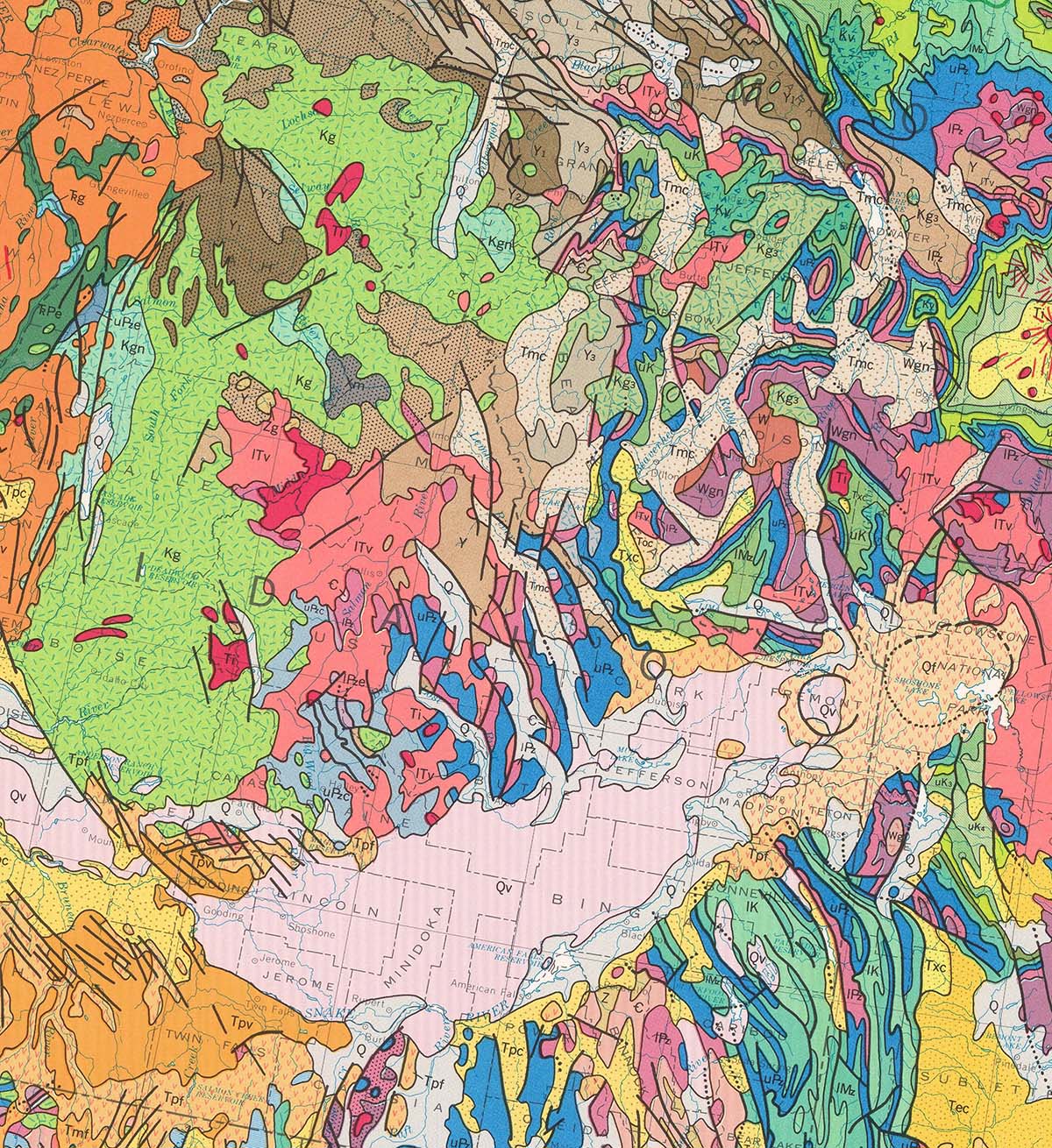 Map 1. Snake River Plain and Yellowstone. The Snake River Plain, beneath that long flat stretch of Interstate 84, is covered by Quaternary age basalt flows. The landscape is flat because the lavas are flat –and so they show up as a big swatch of pink. Compare it to the ribbon-like bands to the north and south, mostly steeply inclined, folded, and faulted sedimentary rock of the Fold-Thrust Belt. The white stripes between the ribbons mark valleys (they’re filled with alluvial deposits) so we can infer that the ribbons, which mark bedrock, are mountains–which they are.
Notice how the Snake River Plain cuts across the ribbons of the Fold-Thrust Belt. It’s much younger: the lavas all erupted over the top of the older, deformed rock. You can actually see that relation if you drive US20 along the north side of Craters of the Moon National Monument.
And just beyond the Snake River Plain to the northeast, you can see Yellowstone, marked by rhyolites that also cover the older, surrounding rocks. Yellowstone is on trend with the Snake River Plain because they are both products of the southwestern drift of the North American Plate over the Yellowstone Hot Spot. Lying beneath the Snake River Plain Basalts are former rhyolitic calderas like Yellowstone. You can see some of these rhyolites at Shoshone Falls in Twin Falls, Idaho.
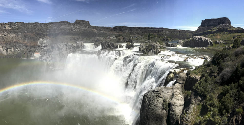
Shoshone Falls spills over light-colored rhyolites. Rocks on the skyline are Snake River Plain Basalt, Idaho
Then there’s the Idaho Batholith, shown as the green swatch, which formed because of subduction along the western margin of North America during the Cretaceous Period. It’s of about the same age and origin as the Sierra Nevada in California.
 Map 2. The Basin and Range Province. Described by the geologist Clarence Dutton in 1884 as “An army of caterpillars”, the Basin and Range consists of alternating basins, shown by the white color for alluvium, and ranges, shown by the colors, indicating various types of bedrock.
Geologically, the province is varied and complex, and I can’t begin to do it justice here except to say that much of the modern day landscape is a product of crustal extension –so many of the ranges are bound by normal faults, in a manner akin to the illustrations below. It’s quite a wonderful part of the world and includes Death Valley, my go-to place for all things geology.

Aerial view across the Basin and Range Province in Nevada.

Tilted fault blocks. The photo of Death Valley region as tilted fault blocks coincides with the inset on the cross-section.
And notice how the southeastern part of Map 2 includes the ribbon-like patterns of the Fold Thrust Belt –and southeast of there, the broad swales of the Colorado Plateau! (Map 3).
Map 3. Colorado Plateau. In preparation for a field trip to the Colorado Plateau, my grad school thesis advisor described the region as “an island of tranquility surrounded by tumultuous Cenozoic deformation.” I’ll never forget that –so accurate a description and such flowery language!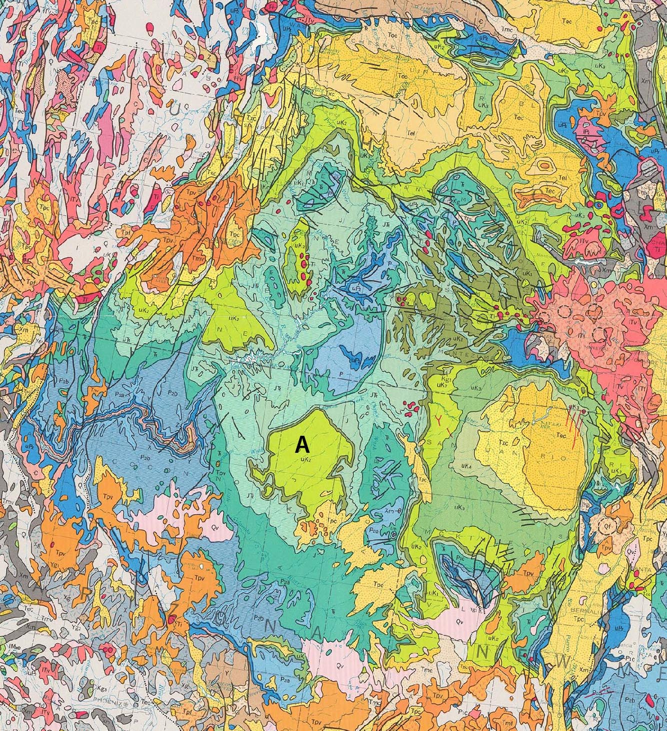

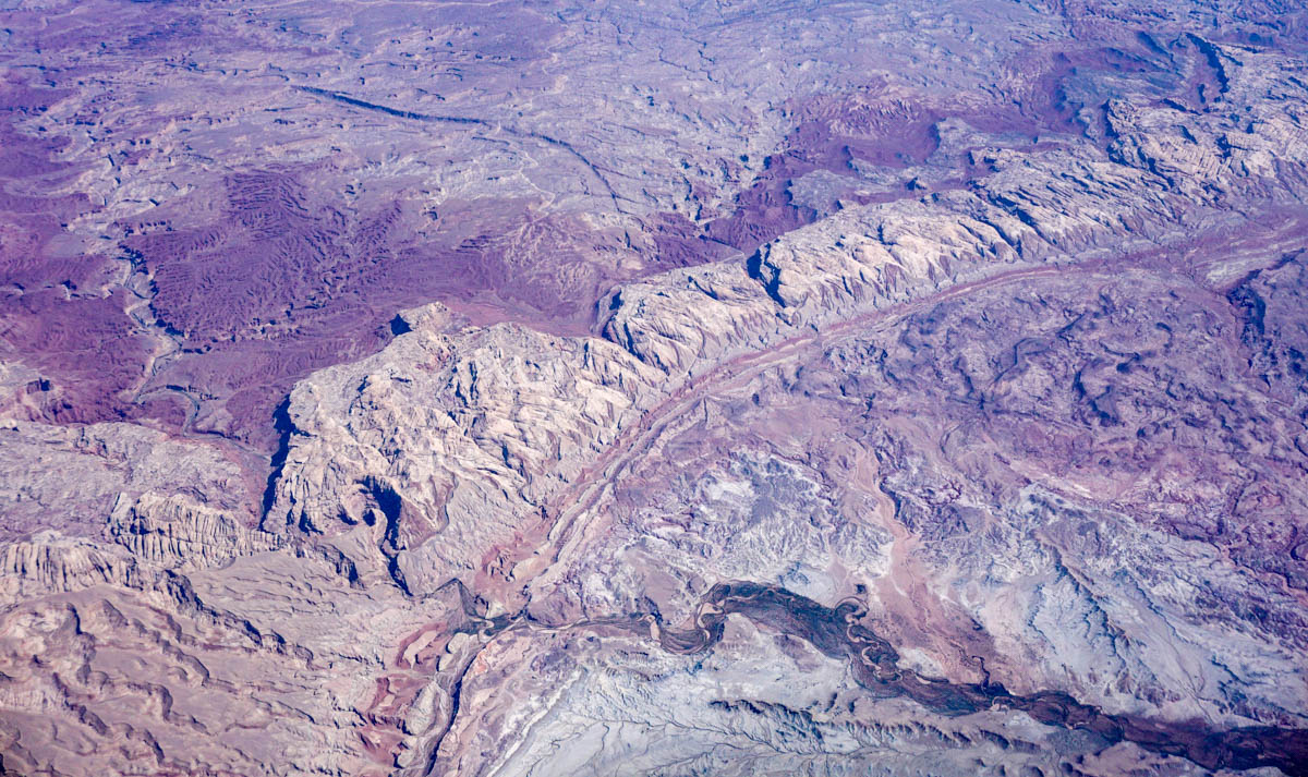
Aerial view of incised meanders of the Green River cutting through flat-lying rock, Utah.
From the map, you can see that the region is marked by wide color swatches edged by narrow ribbons. The swatches mark approximately flat-lying sedimentary rocks and many of the ribbon-like edges mark monoclines, where the rock flexes from flat-lying to steeply dipping to flat-lying again, like the photo below of the San Rafael Swell. The monoclines formed in the early Cenozoic because of faulting in the underlying basement rock.
Aerial view of the southern San Rafael Swell, Utah
In some places, such as Black Mesa (location “a”) in northern Arizona, you can see the ribbons surrounding the swatch. These areas typically mark individual plateaus, capped by flat-lying rocks with older rocks exposed on the slopes below. And in the Grand Canyon, the ribbon-like patterns similarly form by older rocks exposed downwards towards the river.
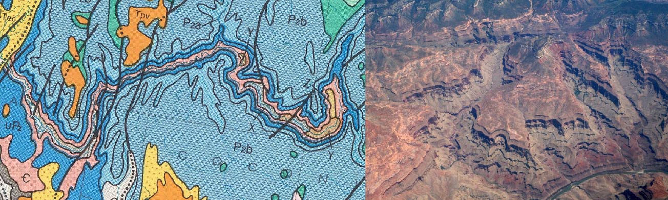
Geologic map and and photo of the Grand Canyon, AZ
And those little red dots? Those are bodies of intrusive igneous rock, including the La Sal, Abajo, and Henry mountains that intruded the Paleozoic and Mesozoic sedimentary rocks at various times during the Cenozoic.
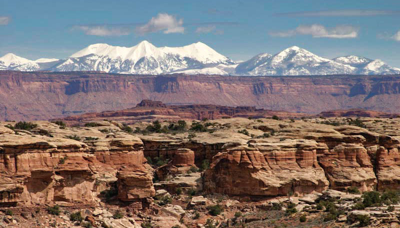
La Sal Mountains rise over flat-lying Paleozoic and Mesozoic rock of Canyonlands National Park, Utah
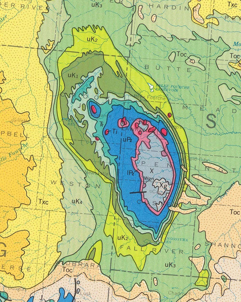 Map 4. The Black Hills rise dramatically from the western plains because they’re a structural dome, a fold in which the rocks dip outwards in all directions, away from the oldest rock in the core. You can see that the rocks get younger out from the core if you click on the image to see it at full size. The core consists of bluish-gray rocks labeled “X” –which indicates an age from 2.5-1.6 billion years and the surrounding rocks are labeled “lPz” then “uPz” then “Tr”, “J”, and “K” to indicate “lower Paleozoic”, “Upper Paleozoic”, “Triassic”, “Jurassic”, and “Cretaceous” respectively. Notice how the rocks dip the steepest on the east side of the dome.

Now if you look at the state of Michigan on the USA map, you can see that it’s the same thing but in reverse. It’s a structural basin, with the youngest rock in the core!
Map 5. Transect across the Appalachians. Starting near the Ohio-Pennsylvania border, you can see that rock is pretty flat-lying because it consists of lots of irregular swatches. The irregularity mostly comes from topographic changes that expose different rocks at different elevations, in a manner similar to some of the features in Map 3. But moving eastward, you hit the Valley and Ridge Province of the Appalachians: long ridges of folded Paleozoic sedimentary rock.

Channel deposit in the Triassic Newark Group, Connecticut.
And then you hit the teal-colored Newark Group, a series of Triassic sedimentary rocks deposited in basins as North America rifted away from Africa. It’s part of the Piedmont, a section of the Appalachians that’s of lower topographic relief than the Valley and Ridge Province, but much more variable in its bedrock geology. It even includes fragments of oceanic lithosphere and mantle, shown in the navy blue color, and Proterozoic metamorphic rock, labeled “Ygn”.
Finally, you reach the Cretaceous sedimentary rocks of the Coastal Plain (shown in green), deposited after the Appalachians had formed and largely eroded. These rocks, as well as the overlying Tertiary rocks are relatively undeformed. Notice how the basal contact of the green “lK” cuts off the contacts within the Piedmont!
 This inset of a close-up of the Valley and Ridge shows a classic example of the zig-zag pattern that results from plunging folds. You can determine the direction the folds plunge by looking at the ages of the rocks: anticlines contain the oldest rock in their cores whereas synclines contain the youngest rocks in their cores. Because anticlines plunge in the direction of their “noses” (where the outcrop pattern zigs or zags), we can infer that these folds are plunging to the northeast.
Map 6. Another view of the Appalachian Coastal Plain. Here’s a great example of a regional, angular unconformity, between the undeformed Cretaceous and younger rocks of the Coastal Plain and the highly deformed rocks of the Appalachians.
And of course, there’s so much more!
You can download a full-sized version of this map from the United States Geological Survey at https://pubs.er.usgs.gov/publication/70136641. It comes in 3 parts: West half, east half, legend.
In the meantime, here are some of my favorite other features:
The Columbia River Basalt Group (orange swatch) that erupted between 16-6 million years ago and covers some 70,000 square miles of Washington, Oregon, and western Idaho.

Lava flows of the Columbia River Basalt Group in eastern Oregon
The Lewis Thrust along the east edge Glacier National Park. The fault brings Proterozoic sedimentary rock of the “Belt Supergroup” over Cretaceous sandstone. It’s a very low angle fault so displays a very irregular trace as it winds in and out of the valleys, kind of like a contour line.

Lewis Thrust, which lies just above the tree line, places Proterozoic rock over Cretaceous rock.
The Ogallala Formation (yellow swatch), only about 6-2 million years old and up to 1000 feet in thickness, covers more than 170,000 square miles of the Great Plains –and provides drinking and irrigation water to the vast majority of people in the region.
Deposits of the Mississippi River (gray). From the Mississippi delta all the way to Cairo, Illinois, the river’s deposited Quaternary alluvium on top rocks as old as Eocene.

Aerial view of meander loops on Mississippi River, Louisiana
Woohoo!
Incidentally, all the photos shown here are available for free download from my geology photo website. It has a search function that accesses more than 3500 images I’ve taken over more than 35 years.

I am new to your site and just wanted to say how much I am enjoying it. I am not a geologist, but your photos and explanations are amazingly helpful. There is nothing like having actual photographs to understand the concepts.
What a generous and amazing site!!! Thank you!
LikeLike
Thank you for the nice comment!
LikeLiked by 1 person
Fantastic post. Thanks!
LikeLiked by 1 person
Thanks for this clear and beautifully illustrated exposition. A geological map of Britain and Northern Ireland is freely available at http://mapapps.bgs.ac.uk/geologyofbritain/home.html. This one can be expanded to street level, and clicking on a location will give you a description of the bedrock, and the surface geology
LikeLike
wow… thanks for the link! I’ve long wanted to get back to the area –I spent a summer in Oxford in 1989, but except for a 2 day layover in London once, haven’t been back since.
LikeLike
Terrific post! This is a great entry point for so many locations! Brava!
LikeLike
Thank you for the nice words!
LikeLike
Hi Marli, longtime reader, first time poster. Love your books/blog/pics! Here’s an zoomable/scrollable version of this map that’s a lot easier to navigate than the huge USGS PDF files: United States Geological Survey Geological Map of the United States. It doesn’t incorporate the legend, though, which is a shame, as those abbreviations are confusing until you’ve memorized them all. Took me quite a while to figure out what “ITa” means, and why there’s so much of it in Cowlitz Co. Lower Tertiary andesite, for those curious – the Western Cascades? But in Oregon it’s mixed up with “TOc” – Oligocene continental deposits. And there are a bunch of intrusive stocks, too. Weird. I thought the Western Cascades were just this wall of eroded igneous junk!
I have a whole bunch of the old editions of Roadside Geology books, which I picked up for cheap years ago, they’re great fun to thumb through; and it’s great people like yourself updated and revised them. Did you get the nod of approval from David Alt and Donald Hyndman?
LikeLiked by 1 person
Thanks for the nice note! And I’ll be sure to check out the link you sent. Yes– you really do need to have the legend nearby to consult –it helps with so many of the details!
Mountain Press reached out to me directly for RG Oregon –and the after that, asked me if I would do Washington. Alt and Hyndman were not involved in the recruitment –but I was happy to hear that David Alt gave my Oregon book a thumbs up before he died.
LikeLiked by 1 person
Pingback: A US Geology and Art Tour – Dr. Roseanne Chambers
Hello Marli, I just discovered your blog site from a link from another Geology blog which was posted on FB. I recognised your name from a book reference (Geology of DV or similar title) that someone in a FB group recommended to me. I am a Geologist from Switzerland, but veered to GIS, data management and now scripting in Python after I finished my studies, years ago. I was recently searching for an online overview of all Geology of the US and got that link to the USGS mapview which is quite amazing. I have been visiting the States a lot between 2011 and 2016. Many trips, some quite long (had to get a 6 months multi entry visa!), I realised that DV is endless, as well as almost all NP and National Monuments in CA, UT, AZ, and I have not touched much New Mexico neither NV!
Anyhow, thanks a lot for sharing your knowledge and insights, your blog is very nice to read, seems non Geologists appreciate it a lot too, which shows that your pedagogical skills are high level 🙂
I live now in Norway, which looks quite different than the beautiful deserts of South West USA. Take care, and looking forward to reading more from your blog, cheers, Anne 🙂
LikeLike
Hi Anne,
Thank you for the nice note! And yes, Death Valley is endless –so many places there I have yet to see. But Norway –I’ve never been there and I hear it’s wonderful! I do hope to visit sometime and see the fjords and mountains.
–Marli
LikeLike
Hi greaat reading your blog
LikeLike
Thank you!
LikeLike
Thank you so much for this wonderful exposition and text! I was amazed by the map and children in my “Geoclub” at school fell immediately in love with your stories and pictures (I translated a few of your comments on map and photos in czech). I am geologist, but I work as a teacher on high school in Czech republic. We are now dealing with geologic maps and your page is very helpful as an introduction! Thank you!
LikeLike
Thank you for the nice words! I’m so happy you and your students enjoy my site. Please let me know if you need any photos!
LikeLike
Thank you for the inspiring compiled geological work. You have made me have a long geological trip in areas that I will never visit physically with your photos. I feel satisfied with the general view that you have outlain. Fantastic job!
LikeLike