Oregon’s geologic history. A new cross-section and timeline –and some great places to see it.
Oregon sits at the very western edge of the North American Plate, an “active” plate margin in the truest sense of the term. There’s active uplift on the coast, active volcanic activity in the Cascade Range, and active crustal extension to the east—not to mention the active subduction just offshore that’s driving most of it. And the products of all that activity are today’s amazing beaches, forests, sand dunes, playa lakes, plateaus, mountain peaks, rivers –the list goes on.
Collectively, those landscapes paint a picture of Oregon and its geology today. But Oregon’s geologic history stretches back some 300 million years to its oldest rocks of Devonian age and will continue into the future until who knows when. We live in a snapshot of an unfolding geologic history –and while we can’t see the landscapes of the future, we have the rock record to show us some of the landscapes of the past.

The schematic cross-section above outlines Oregon’s geology, with each different color signifying a different grouping of rock, and therefore, a different part of its geologic history. The heavy red dashed line marks the boundary between Oregon’s “basement rock”—a term that refers to the deepest level crustal rock in a given area—and its cover. Oregon’s basement rock consists of disparate crustal fragments called “terranes” that were accreted to the edge of North America since about 200 million years ago or igneous bodies called “stitching plutons” (in pink) that intruded the terranes. The cover consists of sedimentary and igneous rocks that formed after accretion and over the top of the terranes.
Fun fact: Oregon has the shortest geologic history of any state in the conterminous US! That’s because its geologic history only goes back as far as the oldest rock of its oldest accreted terrane, which is some Devonian (419-359 million years) limestone in the Blue Mountains. All the other states have basement that includes rock of Precambrian North America. In many states, this older rock isn’t exposed, but we’ve seen it in well cuttings or on seismic lines. In Oregon, it’s simply not there! –the basement has all been added onto the edge of the ancient continent.
Oregon might have the shortest geologic history, but it’s certainly one of the most eventful. Accretion of each terrane likely spawned a mountain-building event, and the Blue Mountains, Klamaths, and Franciscan Assemblage each consist of multiple terranes. And if you look at the cover rock, you can see just how variable it is. Rocks of the John Day Basin shown in green, for example, consist of a sequence of volcanic and sedimentary rocks that reflect changing landscapes and climates in central Oregon from about 48 million years to about 8 million years ago. So the cross-section is highly simplified and schematic: the actual story expands infinitely as you learn more about it.

Using the cross-section, you can come up with a geologic timeline like the one above. The large letters on both the timeline and cross-section refer to the 7 locations described here while the many small numbers on the cross-section and time line refer to each of the 60 sites in my new book: “Oregon Rocks! A guide to 60 amazing geologic localities”. It just went to the printer and should be available sometime in mid-April. I’m beyond excited. It was a really fun project for the past three years, I visited a lot of places I’d never been before, and I learned a lot. And despite its cheesy title, I think it’s a great book and I’m really proud of it. I also had another wonderful experience working with the publisher, Mountain Press.
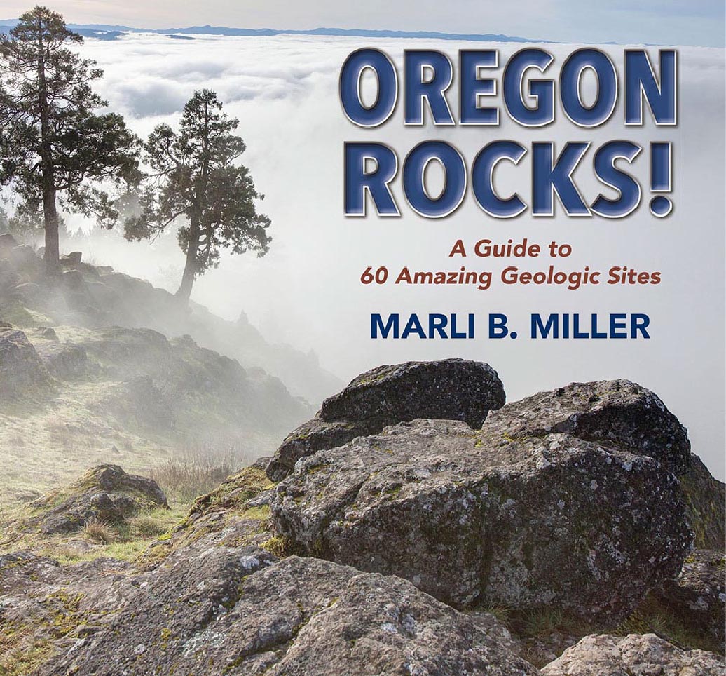
Here’s a copy of the book’s front cover!
So here are some sites that collectively, show much of Oregon’s geologic history. They’re in chronological order, beginning with A. terrane accretion and intrusion of stitching plutons; then B, post accretion sedimentary rock; C, the John Day Basin; D, Eruption of the Columbia River Basalt Group; E, High Cascades Volcanism; F, Basin and Range crustal extension; and finally G: modern-day coastal uplift. And the photos? All out-takes from my book. I simply had too many to use! So here are some that didn’t quite make it –and you can click on them to see them enlarged.
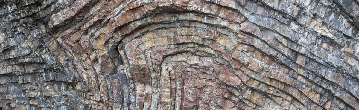
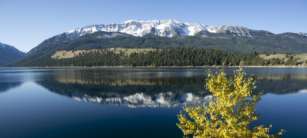
A. Terrane accretion and intrusion of stitching plutons: The View from Joseph
(site #54 in Oregon Rocks)
The Wallowa Mountains rise like skyscrapers along a fault zone just outside the town of Joseph –so from just about anywhere in town, you can see accreted rock of the Wallowa Terrane, as well as granitic rock of the Wallowa Batholith (light blue and pink on the cross-section). The granite intruded the Wallowa Terrane as a series of smaller plutons between 140 and 122 million years ago, probably at a depth of about 5km.

From Joseph, you can also see bits of Columbia River Basalt perched high on the mountains. The basalts originated from fissures in the local area and once covered the entire region. With uplift of the range, however, the lavas mostly eroded. And if you go hiking in the Wallowas, you can see all the rocks up close, including those fissures, which are now preserved as basaltic dikes. Here’s an earlier blog post—with more detail– about this view.
B. Post-Accretion sedimentary rock: Cretaceous Conglomerate at Goose Rock, John Day Fossil Beds (site #49 in Oregon Rocks)
The sediment that gets deposited over the top of a terrane after it’s been accreted helps us determine just when the accretion took place. And because accretion of different terranes occurred at different times, their overlapping sedimentary rocks are of different ages. These conglomerates, beautifully exposed in the Sheep Rock Unit of John Day Fossil Beds National Monument, were deposited in streams during the Cretaceous Period about 115 million years ago, telling us that the underlying Baker Terrane was accreted no later than that. If you go westward to the coast, you can see the much younger (~45 million years) Tyee Formation, which was deposited on the accreted Siletzia Terrane (sites 9, 10 in the book).

C. Rocks of the John Day Basin: Sheep Rock unit of John Day Fossil Beds.
(site #49 in Oregon Rocks)
Sheep Rock is the biggest –and arguably most instructive—part of the three units of the John Day Fossil Beds National Monument. Not only does it contain the Goose Rock Conglomerate of location B, but it also hosts the Thomas Condon Paleontology Center, and shows off all rock units of the rocks of the John Day Basin above the Clarno Formation. You can see beautiful exposures of volcanic mudflows of the Clarno Formation in a series of pinnacles at the Clarno unit of the national monument (site #48).

The John Day Basin rocks are important for a variety of reasons, none the least being they host a world-class treasure trove of mammal and plant fossils from the Eocene through the Miocene. They also preserve a clear record of climate change, from tropical to subtropical climates in the Clarno to temperate forests and grasslands in the John Day Formation, back to subtropical conditions in the middle Miocene during eruption of the Picture Gorge Basalt and lower part of the Mascall Formation, and then back to cooler and drier climates for the upper part of the Mascall and the Rattlesnake Formations. And the rocks are so pretty! They consist mostly of air fall tuffs that lingered long enough on the surface to turn into soils –and their colors make for a general –though not exact– proxy for the climate. The dark red soils reflect deep weathering in tropical climates, and lighter browns and tans formed in cooler climates. The green color of much of the Turtle Cove Member of the John Day Formation comes from the mineral celadonite, which formed from chemical alteration of the original rock– much of which formed from ash erupted from the giant Crooked River Caldera (site #33).
D. Eruption of the Columbia River Basalt: Silver Falls State Park.
(site #23 in Oregon Rocks)
Just east of Salem, Oregon, Silver Falls State Park hosts some 15 waterfalls that flow over the Grand Ronde and overlying Wanapum Basalts –members of the Columbia River Basalt Group. Here, you can actually walk behind many of the waterfalls and contemplate this amazing basalt, which erupted in northeastern Oregon and flowed some 200 miles to get here –and continued for another 100 miles to Oregon’s coastline!

The Columbia River Basalt Group so dominates the geology of northern Oregon and southern Washington that I’ve already blogged about it here –but suffice it to say that it erupted between about 17 and 6 million years ago and covers more than 70,000 square miles with a volume of more than 50,000 cubic miles. Some 94% of the lavas erupted by 14.5 million years ago—which means that some 46,000 cubic miles erupted in a period of less than 2.5 million years. Imagine!

Still, there were quiet periods, lasting tens of thousands of years or longer –and if you go there, you’ll see stream-deposited sedimentary rocks between the Grande Ronde and Wanapum Basalts. The sedimentary rocks erode much more easily than the basalt and so make the large alcoves behind North and South falls, which drop 136 feet and 177 feet respectively. And the hiking trails, which are pretty awesome in themselves, actually pass through these alcoves behind a curtain of falling water.
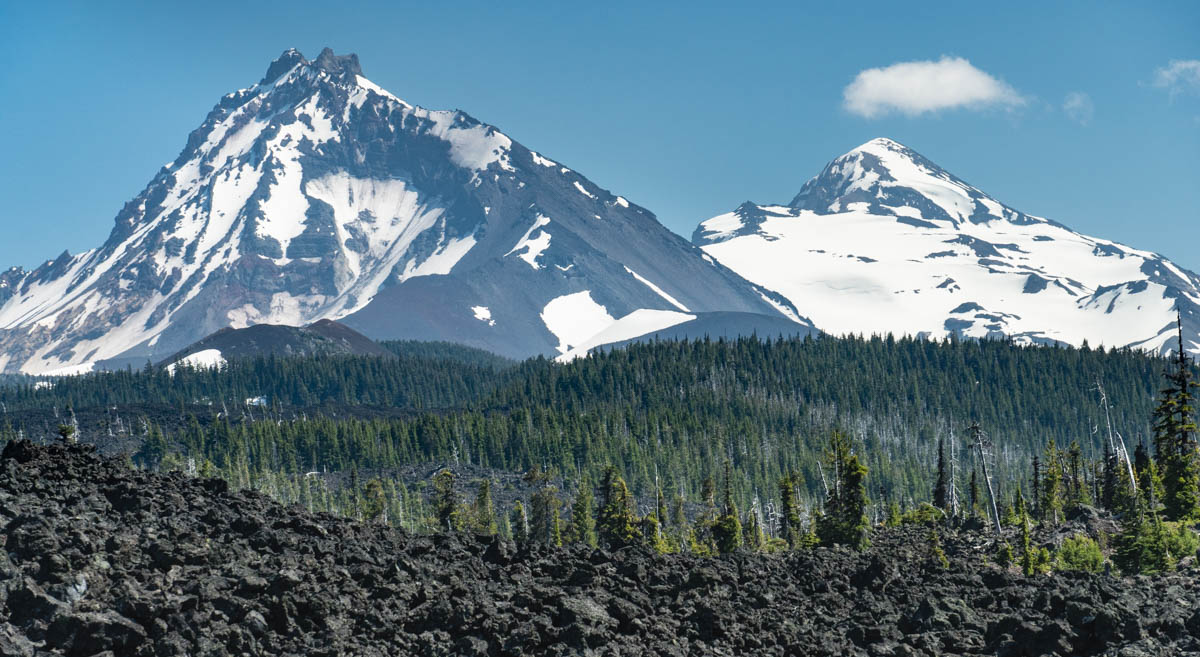
E. High Cascades Volcanism: McKenzie Pass
(site #26 in Oregon Rocks)
If there is just one thing that Oregon’s geology is known for, it would have to be its range of potentially active volcanoes, the High Cascades. A direct product of subduction, these volcanoes make a line that continues south into northern California and north as far as southern B.C., Canada –but most of the volcanoes lie in Oregon.
And the range is so variable—with all types of volcanoes that have erupted all types of lavas and tephra over the past 6-8 million years. And before the High Cascades, the western Cascades (just to the west) were actively erupting back as far as 40 million years ago—even providing some of the ash in the John Day Formation. Today’s active volcanoes are all much younger than that, creating a landscape that’s mostly on the order of 10s of thousands of years old. Some of the volcanoes, like Mts Hood or Mazama/Crater Lake (sites 22, 28) have histories that go back about a half million years –but the landscape is strikingly fresh.

McKenzie Pass gives a wonderful sense for the High Cascades. You can walk a trail through basaltic lavas that erupted only two thousand years ago and take in spectacular views of nearby mountains, representing a variety of volcano types. These mountains include Belknap Crater, a basaltic shield, Mt. Washington, an eroded shield, Mt. Jefferson, an eroded andesite stratovolcano, Black Butte, an incredibly symmetrical but small stratovolcano of basaltic andesite –and just to the south, you can see Middle and North Sisters, made of basalt and basaltic andesite respectively. Phew!
F. Basin and Range Crustal Extension: Steens Mountain
(site #57 in Oregon Rocks)

When the snow’s gone, you can drive much of the way up Steens Mountain near the southeastern corner of the state—and from there, it’s a short hike to the summit. At an elevation of 9734’, it’s the highest spot for more than a hundred miles –and the view is fantastic. Looking eastward, you look down the steep escarpment to the Alvord Desert, more than a vertical mile below; westward, you can look down long glacially carved canyons that descend at a much gentler grade. Like other mountains of the Basin and Range Province, Steens formed—and is still forming– as a tilted fault block, with a normal fault along one side that causes the mountain to rise steeply along the fault and tilt gently back in the opposite direction. Just like the cross section below.

And the rocks! They consist mostly of the Steens Basalt –which is the oldest part of the Columbia River Basalt Group. There’s plenty of opportunity to see (and pet!) these rocks as you drive up the gravel road (High clearance) –and from the summit, you can look over hundreds of the Steens lava flows and see that they’re cut by dikes –the frozen conduits of later erupting lavas.
G. Modern Day Coastal Uplift: Sunset Bay and Shore Acres State Parks
(site #13 in Oregon Rocks)
To see the effects of ongoing coastal uplift in Oregon, one of the best places is undoubtedly Sunset Bay and Shore Acres State Parks, just west of Coos Bay. At low tide, Sunset Bay displays an incredible wave-cut platform, a flat surface that formed by wave erosion of the local bedrock. Besides the wonderful tide-pooling, the surface creates a geologic marker; if it were uplifted, we would see it as just that: a flat surface on top the uplifted bedrock.
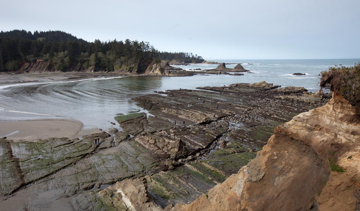
And that’s just what we see! On either side of the bay, the cliffs are capped by a marine terrace, a surface that, just like the one hosting today’s tidepools, formed at sea level. Only now, it sits some 20-30 feet above the waves. And if you go to Shore Acres a mile to the south, you can walk around on this terrace and see the incredible waves.

And why are the waves so big at Shore Acres? I’m not entirely sure, but I think two things are at play. First and probably foremost, there is no wave-cut platform in front of Shore Acres like there is elsewhere along that part of the coast, so the waves collide with the cliffs with nothing to slow them down. Also, a cursory look at the sea floor bathymetry shows that the 120’ depth contour is just over 1.5 miles away from Shore Acres, whereas to the north and south, it’s closer to 2 miles away –or even greater. All that extra water has to go somewhere when it hits bottom –which is upward.

One of my favorite things about geology is how we can piece together a coherent picture of a region’s geologic history from a bunch of different places–places we might otherwise think are completely unrelated. And once you have an outline of the story, you can start filling in all sorts of amazing details the more you learn. Think how diverse and wonderful our landscape is today. Landscapes of the past were diverse and wonderful too –and the more we study the Earth, the more we can experience them.
For more geology photographs –of Oregon or elsewhere–please visit my site geologypics.com.

This is so good! Much appreciated!
Sent from my iPhone
>
LikeLike
Pingback: Exploring Western US Geology – Dr. Roseanne Chambers
If you ever decide to come to California and do for it what you are doing for Oregon, I would love it lol
Until then, I am totally enjoying reading about Oregon and your wonderfully detailed description 😀
LikeLike
Thank you! I would love to do a project like that –but there already is a book called “California Rocks!” by the same publisher. 🙂
LikeLike
Hi Marli…I got your Roadside Geology of Oregon a few years ago but didn’t really crack it open until I started watching Nick Zentner’s videos, including one in which you were featured that got me back into a semi-serious geologic mode. I like the way you captured a lot of the current thinking about big-scale development of the geology of the PNW. Looking forward to Oregon Rocks. This stuff is tough to get my head around sometimes so the more “takes” on it, the better I do. Trivial detail in the blog above: you inadvertently wrote that Silver Falls is west of Salem when we both know it is east! Thanks for all the great work!
LikeLiked by 1 person
Thanks for the nice words –and for pointing out that silly mistake! I’ll fix it right away!
LikeLike
Love the website and Roadside Geology book! I am going to be doing a presentation on fossils of Oregon this winter, and I’m wondering if I could use your cross-section and timeline of Oregon in my slides (with credit to you of course!)?
Cheers,
Brian
LikeLike