“Oregon Rocks!” My new book about Oregon’s Wonderful Geology
I’m very happy to announce that my new book, Oregon Rocks! A guide to 60 Amazing Geologic Sites, is out there and available. Although the title always makes me cringe a little, I’m excited and proud of this project, which took me three years to complete and took me all over my beautiful state. At the risk of being overly exuberant, here are some excerpts!
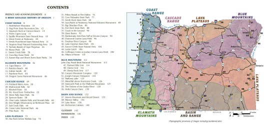
If you click on the image below, you can actually read the table of contents (left) and study the site map. Both these illustrations group the sites in one of Oregon’s six physiographic provinces: The Coast Range, Klamath Mountains, Cascade Range, Lava Plateaus, Blue Mountains, and Basin and Range.
The site numbers are especially important –not only because they key to the map location and page numbers in the book –they also refer to the timeline and schematic cross-section across the state. I’m especially proud of this part because it lets you place each site into the context of how the entire region evolved. Click on the timeline and maps below to see what I mean!

As an example –say you hike up Spencer Butte, just south of Eugene. It’s a great hike, by the way –and graciously posed for the cover photo. You can see from the geologic map (lower right) that it’s part of the western Cascades –and you can find the same site on the timeline in the same color –and on the cross-section. From the cross-section, you can see more context: the western Cascades are cut by intrusive bodies (which include Spencer Butte) and predate the High Cascades and are part of the cover sequence overlying the accreted terranes.
Please check out my earlier post about this cross-section and Oregon’s geologic history if you’re interested!
And here’s some of the interior! Most sites consist of two facing pages, but some are just a single page, and others are 3, even 4 pages long. The book measures 9″ by 8.3″ and totals 154 pages in length (160 if you count the front matter) all in color. It has more than 180 of my photos and more than 70 maps and diagrams. Chelsea Feeney employed her map wizardry to make the maps and diagrams look really beautiful.
Many of the photos are available on my geology photo website for free download –and I’m working to add more if you want or need any for your own purposes –and by all means, if you’re teaching a class or something like that and are looking for specific images, please contact me!
Many of the photos are available on my geology photo website for free download –and I’m working to add more if you want or need any for your own purposes. And by all means, if you’re teaching a class or something like that and are looking for specific images, please contact me!

And if you’re interested in purchasing the book, you can get it from Amazon or direct from Mountain Press –and Mountain Press has tons of other great geology books too!
Thanks for reading!


Just when I thought I had all the best Oregon geology books, you go and publish an even better one! I could never NOT buy a Marli Miller geology book. Going to order two now, one for me and one for my rockhound son who owns a rock-themed coffee shop on SE Foster in Portland. (You met him – and me – once when you came to speak at McMenamins Cinema in NW Portland.)
LikeLiked by 1 person
(I just posted this on the GSOC Facebook page.)
LikeLike
Thanks Wes!
LikeLike
Wow congratulations! I will make sure to have it next time I go to Oregon. I assume the title is from being part of the … Rocks series, so guessing you had no choice …Melodie Frances Sent from my Verizon, Samsung Galaxy smartphone
LikeLiked by 1 person
Congratulations Marli! I’ll be adding it to my collection. Cora Helm Helena MT
LikeLiked by 1 person
Can’t wait to get my hands on it! Congrats!
LikeLike
Looking forward to this book and your description of Shore Acres State Park and all the other 59 locations!
LikeLike
This is a very good book. I have had it for about a week and keep picking it up and reading a bit more. But is there a reference website for all the geological terms being used? That would be useful.
LikeLike
Hi Paul, Thanks for the nice comment –as far as the geologic terms, there’s the glossary at the end of the book –beyond that, I’m sorry, there’s not a reference website. However, my guess is that you could google just about any of those terms for a quick definition.
LikeLike
Thanks Marli.
LikeLike
Love the book! Makes me want to go to Oregon (I’m in BC ;). I wanted to ask which software did you use for the timeline, looks so neat!
LikeLike
Thanks for the note –and I’m glad you like the book! I used Adobe Illustrator for the timeline –but the publisher improved on my original version –and I’m pretty sure they used Illustrator as well.
LikeLike