Skill and Spirit: Teaching field geology on public lands

Something different here: an essay I wrote about teaching field geology on public lands– published under the same title in the March, 2021 issue of Desert Report with a few extra photos added (please click on the photos to see them larger). I guess I’m hopeful –even optimistic– that I’ll be able to teach field camp again this summer!
******************
Six pairs of eyes stared blankly at me. Cows. Amazing how big those creatures are, especially when you’re sitting on the ground so I was grateful they hadn’t already tried to share my tiny bit of shade. I stood up, shouldered my pack, and walked into the bright sun.

I’m in southwestern Montana, teaching a field geology class. It’s public land, a place I bring my students year after year without fear of locked gates or fences. Besides the great geology, we see awesome views in all directions, innumerable cacti, wildflowers, and sagebrush, occasional wildlife, and of course, cattle. But we come for the rocks: layer after layer, deposited as seafloor sediment, coastal dune, or river gravel over a period spanning some 300 million years. We’re in what’s called the Rocky Mountain Fold-Thrust Belt, where the layers show twists and turns you can’t imagine, and fault zones that caused mountains to rise long before the present landscape even began to form.

And because the area’s managed by the Bureau of Land Management, we can go pretty much anywhere and everywhere over this 3 or 4 square mile area, just like the cows. Each student creates a detailed geologic map. They identify the rocks, draw lines on their maps to show the boundaries between different rock units, and use their maps to interpret the geologic history. It’s difficult work and highly rewarding ‒ and most students complete the course with a new-found sense of confidence and competence.

I spot some students on a nearby ridge and veer off the gravel road to meet them. The sagebrush near the road is high, but as the slope steepens, it gives way to grass and ledges. On cresting the ridge, I call out:
“How’s it going?”
“Okay” one of the students replies. We look at each other stupidly. I have no idea who it is.
“Hope you’re having a good day!” I say cheerfully and walk on.
These students aren’t mine. They’re from one of the many other universities that come here to teach field geology skills. With so many students tramping over this landscape every summer, following existing paths to key outcrops or creating their own, breaking pieces off the bedrock so they can inspect fresh surfaces, I sometimes worry that we might love this place to death.

I feel a slight cooling breeze and sit down. In front of me, the rocks form a rounded arch shape ‒ a product of crustal compression that built mountains here some 80 million years ago. The frustration of chasing down the wrong students morphs into gratitude. I think of the many students who’ve told me, years later, how much they learned here and how much it shaped their careers. Many describe how blending physical exertion with their academic backgrounds led to a sense of discovery they’d never before experienced.
I watch a pickup truck approach the cows down on the road. It slows briefly to pass by and then continues up the gentle grade. Multiple use ‒ that’s the BLM mantra. Besides grazing and wandering geology students, this place is open to energy development, timber harvesting, and all sorts of recreation. By comparison, our impact is small ‒ and the geology here will outlive all of us, no matter how many cattle trails we follow, or create, or how many outcrops we hammer. I’m grateful for our freedom to wander, pursuing education anywhere and everywhere here, and to arrive anytime without having to fill out any kind of paperwork.
****************************
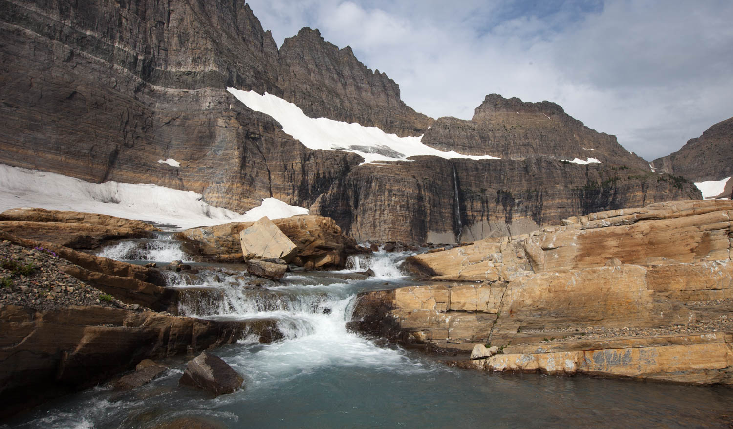
Ten days later, I’m sitting on a block of limestone, listening to water cascade over some ledges before coalescing into a narrow stream. Above me, soaring cliffs of Helena Dolomite form the headwall to the once mighty Grinnell Glacier. Some of the glacier persists high up in this cirque, but the retreat has been so rapid and recent that the glacial scratches across the bedrock are still fresh. Two of my students sit silently, gazing upwards to the headwall. Another studies a rock with a hand lens. Two others slowly make their way towards my perch.
Glacier National Park hosts a vast wilderness of landforms designated by glacial terminology: peaks called horns, ridges called arêtes, cliffs called headwalls, bowl-shaped valley heads called cirques, rock-bound lakes called tarns, deep U-shaped valleys called U-shaped valleys ‒ all carved by glaciers into this amazing bedrock. I ponder what this place must have looked like 15,000 years ago when glaciers were at their maximum. The peaks and some ridges would be recognizable but the valleys between them would be filled with ice that extended in long strands to the edge of the Great Plains.

One of my students practically shrieks with excitement. I’ve been waiting for this: they found the stromatolites, fossilized algae ‒ Earth’s oldest easily visible life form. Resembling an onion in cross-section, these thin concentric layers of rock formed when dome-shaped bodies of algae in shallow clear water trapped sediment as they grew. The ones here, which reach a meter or more in diameter, are the largest and most dramatic I’ve seen.
I watch the other students hurry over as the contemplative mood lights into a spontaneous revival. One student starts laughing. Another exclaims, “Look at this one!” another says, “Oh God!” another: “And the glacial striations go right across them!” Another turns to me quizzically: “How old are these rocks?”
I smile. “I just read that they were all deposited between 1.4 and 1.47 billion years old ‒ so somewhere in there.”
Another question: “And these glacial striations, maybe 10 or 15,000?”

I keep smiling. This spot is one of my all-time favorite places. We hiked the five miles up here for sunrise and now, mid-morning, still have the place to ourselves. The landscape is so fresh and raw ‒ so untouched ‒ that we feel a primeval kinship with this rock and ice.
I finally answer. “Or younger. This place was under ice just thirty years ago. There’s still some glacier left, just across the lake. So much change, huh?”
Many of my students have visited national parks before, but this is the first time they’ve come as geologists. They now see things through the lens of geologic time and process ‒ and for the first time, they are applying their knowledge to a landscape that not only surrounds them, but is beautiful and pristine. They learned important skills earlier in the course on BLM land and here they combine those skills with their human spirits.
We cross the stream and start picking our way up the ledges on the other side, finding more stromatolites as we go. I hear my students talking about landscape and time. Like me, they can relate to today’s landscape, and can imagine the scene during the glacial maximum some 15,000 years ago, but the shallow inland sea in which these rocks formed seems beyond comprehension. Its age, about 1.4 billion years, makes it all the more inconceivable. And what does the word “about” mean in this context anyway? If the rocks formed 1.41 instead of 1.40 billion years ago, they would be a full ten million years older. As geologists, we bandy these ages around with comfort, but when we really think about it, we can’t comprehend 10 million years, let alone a billion.

I stop and consider a series of stromatolites in front of me. They’re exposed on both the front and upper sides of the ledge, giving three-dimensional views of their mounded shapes. Weathering and erosion rounded off many of the broken edges, accentuating the stromatolite’s appearance. For a second, I think I can see them breathe.
Our little group falls silent as we watch a rain squall farther down the valley. What a vast open-air cathedral we’re in! Public lands, be they national parks or forests or open BLM land, house these wonderful places and welcome everyone who will make the journey.
To see more geological photos from from SW Montana or Glacier NP, please see my geology photo website, where you can use keywords to search among >4000 images and download them for personal or instructional uses for free.
