geologictimepics

Geology and Geologic Time through Photographs

Archive for the category “young earth creationism”

Scientists, Science, Icicles, and Faith

In January, I started teaching the Introductory Geology course “Environmental Geology and Landform Development” –with two lecture sections of about 200 students each. And this course, populated largely by folks who are fulfilling a science requirement and  otherwise try to avoid science like it was the plague, needed some general statement about science. After all, it’s science that may someday save them from the plague!

So science… what is it? Seems like scientists themselves have a zillion different definitions, so I started with “Scientist. –What’s a scientist?” If you google “scientist” and then look at the images, you see this. As this image is a screenshot of photos that aren’t mine, I intentionally blurred it, but you should get the idea of what’s there.

lec1-allrb

Really??? these are the most popular images of scientists and in every picture–save the tiny one in the lower right– is some person in a WHITE LAB COAT and a microscope or a beaker. Ironically, it shows about 50% of the scientists as women. Go figure there too.

Looks like we’ve been fed a misrepresentation of what scientists are. We actually do a wide variety of things. In geology, we do a wide wide range of things. We spend time in the field (see picture below), we write, we draw maps and cross-sections, we look down microscopes (maybe in jeans and t-shirts), we write computer models, we do experiments, and we sometimes wear white lab coats.

130324-17c

Geologist inspecting a fault zone between the dark-colored Beck Spring Dolomite and the overlying light-brown Noonday Dolomite. Death Valley, California.

All the time, we’re trying to understand something about our world. Our universe. We’re collecting information (data). We’re testing ideas. We’re adding detail to somebody else’s ideas. We’re building a framework of knowledge that’s grounded in our observations and testable ideas. Replace the word “ideas” with “hypotheses” in this paragraph –and you get science.

Ideally, most scientists approach their work using the “scientific method” –which is a highfalutin way of saying they see something they don’t understand (an observation), which causes them to ask a question (like how did this happen?); they come up with ideas (hypotheses) that may explain it, and then they test those hypotheses.

ice-stufflr

Icicles?

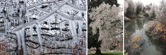
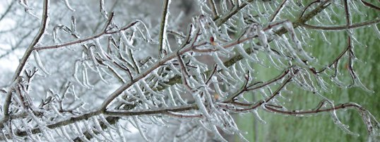
Which is what we did in class with icicles! The month before–in mid-December–Eugene had this incredible ice storm, which covered everything in ice to make it look like a scene from the movie Frozen. It was beautiful and destructive. And we can all pretty much guess how icicles form: water starts to drip off the branch but freezes before it falls off. Icicles grow straight downward off the branch because water, like everything else, falls vertically with gravity.

As it turned out, some of the icicles seemed to grow straight out from the branches. Look at the photo below! How could this be? We know icicles should grow straight downwards! So as a group, we came up with some hypotheses, shown below next to the picture. I was the proud sponsor of hypothesis #4 and #5.

lec1-c

Alternate hypotheses to explain near horizontal growth of icicles

As a group (all 200 of us), we could rule out hypothesis #3, that the picture was rotated. I shot the image and promised I didn’t rotate it! We could also rule out hypothesis #4, that the ice somehow grew horizontally towards the branch, because that idea conflicted with all previous observations we’d made on icicles, that they grow away from the branch as ice progressively freezes.

That left hypotheses #1, #2, #5. We figured ways we could test #1, #2. If it were the wind, for example, we’d expect all the icicles to go in one direction in a given place, regardless of the limb angle. If it were #2, we might expect to see some icicles show a curve to indicate progressive tilting of the branch–which you can actually see in the photo above!

Hypothesis #5, that “Some magical force caused it to grow sideways”isn’t testable. It’s NOT TESTABLE. We can’t come up with ways to support it or rule it out. You can believe it if you want to, but it’s not science.

That’s the point. To be scientific, a hypothesis must be testable. Most of us hold various non-scientific beliefs in our hearts that we know to be true –for us. I think that’s a good thing. For many of us, those beliefs lend us qualities like strength or courage or compassion when we need them the most. They’re still not scientific.

And that’s what really gripes me about the “scientific creationists” –as well as today’s Republican Party. The “scientific creationists” say they use science to demonstrate the existence of God, or that Earth is young –when believing either requires a suspension of science and an act of Faith. By claiming they’re being scientific, the “scientific creationists” hamstring their own belief system. They take the wonder out of religion and render it baseless and sterile.

And the Republicans? They’re now all about “alternative facts”. Maybe it’s unfair to group “all Republicans” together –but I see very few standing up to this reckless leader we have. Maybe they just lack integrity.

161215-7lrcrot

this photo was rotated

Conglomerate!

A trip to Death Valley over Thanksgiving two weeks ago reignited all sorts of things in my brain, one of which being my love of conglomerate. Honestly, conglomerate HAS to be the coolest rock!

151128-3

Tilted conglomerate in Furnace Creek Wash, Death Valley.

Just look at this stuff! Just like any good clastic sedimentary rock, it consists of particles of older rock–but with conglomerate, you can easily see those particles. Each of those particles opens a different door to experiencing deep geologic time.

As an example, look at the conglomerate below, from the Kootenai Formation of SW Montana. It contains many different cobbles of light gray and dark gray quartzite and pebbles of black chert. The quartzite came the Quadrant Formation and chert from the Phosphoria Formation. So just at first glance, you can see that this conglomerate in the Kootenai contains actual pieces of two other older rock units.

3528-38lr

Conglomerate of the Kootenai Formation, SW Montana.

But consider this: The Quadrant formed as coastal sand dunes during the Pennsylvanian Period, between about 320-300 million years ago and the Phosphoria chert accumulated in a deep marine environment during the Permian, from about 300-250 million years ago. The Kootenai formed as river deposits during the early part of the Cretaceous Period, about 120 million years ago. All those are now together as one.

Similar to the modern river below (except for the glaciers), the Kootenai rivers transported gravel away from highlands –the highlands being made of much older rock that was uplifted and exposed to erosion. That older rock speaks to long gone periods of Earth history while the gravel speaks to the day it’s deposited.

120709-123

Athabasca River in Jasper National Park, Alberta

But this is where my head starts to spin: the modern gravel is made of rounded fragments of old rock –so when you look at a conglomerate, you glimpse at least two time periods at once: you see the conglomerate, which reflects a river or alluvial fan –or any environment near a bedrock source– and you also see the particles, which formed in even older environments.

And it gets worse –or better. What happens when you see a conglomerate eroding? The conglomerate is breaking up into modern sediment, which consists of pieces of older sediment –that at one time was modern sediment that used to be older sediment?  Look at the pebbles below. I keep them in a rusty metal camping cup on a table in my office.

151209-4

“Recycled” pebbles of the Kootenai Formation.

These stream pebbles eroded out of the Kootenai conglomerate. So… they’re simultaneously modern stream pebbles and ancient ones –AND… they originated as the Quadrant and Phosphoria Formations. Four periods of time, spanning 300 million years, all come together at once.

And if that’s not enough, those conglomerates in Death Valley? They  contain particles of… conglomerate! Look! The arrow in the left photo points to the boulder of conglomerate on the right. If you click on the photos, you can see them enlarged.

All those particles, which are now eroding and becoming modern sediment, were yesterday’s sediment. And the conglomerate boulder? It too is becoming “modern sediment” and it too was “yesterday’s sediment” when it was deposited on an alluvial fan with the rest of the material. However, it goes a step further: its pebbles and cobbles were both “modern” and “yesterday’s” sediment at a still older time. And before that? Those pebbles and cobbles eroded from even older rock units, some of which date from the Cambrian, about 500 million years ago.

For fun, here’s a photo of another conglomerate boulder.

Conglomerate clast in conglomerate

Conglomerate boulder in conglomerate of the Furnace Creek Formation, Death Valley, CA.


I can’t help but wonder how Young Earth Creationists would deal with these rocks. Given their story of the Grand Canyon, in which the Paleozoic section was deposited during early stages of “The Flood” and the canyon was carved during the later stages (they really do say that too!), they’d probably roll out that same blanket answer: The Flood. End of discussion. No questioning, no wondering.

In my opinion, one of the beautiful things about geology is that we’re always questioning and wondering.


for more geology photos, please visit my website.


Death Valley National Park– Geology Overload!

Death Valley… I can’t wait! Tomorrow this time, I’ll be walking on the salt pan with my structural geology students, gawking at the incredible mountain front –and soon after that, we’ll be immersed in fault zones, fractures, and fabrics!

Death Valley salt pan at sunrise.

Death Valley salt pan at sunrise.

Death Valley presents incredible opportunities for all sorts of geology, especially geologic time; you can look just about anywhere to see and feel it.  Take the salt pan.  It really is salt –you can sprinkle it on your sandwich if you want.  It’s there because the valley floor periodically floods with rainwater.  As the rainwater evaporates, dissolved salt in the water precipitates.  And between 186,000-120,000 years ago, Death Valley was filled by a 600′ deep lake, which evaporated, leaving behind more salt. Before that, more shallow flooding and more lakes.

Aerial view of faulted front of the Black Mountains.

Aerial view of faulted front of the Black Mountains.

But the basin is more than 4 miles deep in some places! It’s not all salt, because there are a lot of gravel and sand deposits, but a lot of it is salt.  That depth speaks to geologically fast accumulation rates, because it all had to accumulate since Death Valley formed –probably in the last 2 or 3 million years.  But still, 2 or 3 million years is way past our realm of experience.

Hiker in the Funeral Mountains of Death Valley.

Hiker in the Funeral Mountains of Death Valley.

To really go back in geologic time though, you need to look at the mountains. Most of the mountains contain Upper Precambrian through Paleozoic sedimentary rock, most of which accumulated in shallow marine environments.  There’s a thickness of more than 30,000 feet of sedimentary rock exposed in Death Valley! Deposited layer after layer, you can only imagine how long that took.

We can measure the thickness of the rock because it’s no longer in its original horizontal position.  The ones in the photo above were tilted by faulting –which occurred during the period of crustal extension that formed Death Valley today.  The rocks in the photo below were folded –by a period of crustal shortening that took place long before the modern extension.  The folding occurred during the Mesozoic Era –more than 65 million years ago.

Aerial view of Titus Canyon Anticline.

Aerial view of Titus Canyon Anticline.

Above the Upper Precambrian to Paleozoic rock are thousands of feet of volcanic and sedimentary rock, tilted and faulted, but not folded. They reveal many of the details of the crustal extension that eventually formed today’s landscape.  For example, the photo below shows Ryan Mesa in upper Furnace Creek Wash.  In this place, the main period of extensional faulting predates the formation of modern Death Valley.  Look at the photo to see that faulting must have stopped before eruption of the dark-colored basalt flows.  Notice that there has to be a fault underneath the talus cones that separates the Artist Dr. Formation on the left from the Furnace Creek Formation on the right.  Because the fault does not cut the basalt though, it has to be older.  Those basalts are 4 million years old, older than modern Death Valley.  –And that’s the old mining camp of Ryan perched on the talus.

Angular unconformity at Ryan Mesa: 4 Ma basalt flows overlying faulted Artist Drive (left) and Furnace Creek (right) formations.

Angular unconformity at Ryan Mesa: 4 Ma basalt flows overlying faulted Artist Drive (left) and Furnace Creek (right) formations.

And beneath it all? Still older rock!  There’s some 5,000 feet of even older Precambrian sedimentary rock, called the “Pahrump Group” beneath the 30,000 feet of Upper Precambrian and Paleozoic rock–and below that, Precambrian metamorphic rock.  It’s called the “basement complex” because it’s the lowest stuff.  Here’s a photo.

pegmatite dike and sill intruding mylonitic gneiss

pegmatite dike and sill intruding gneiss

The pegmatite (the light-colored intrusive rock) is actually quite young–I think our U-Pb age was 55 Ma –but the gneiss is much older, with a U-Pb age of 1.7 billion years.  Billion!  Forget about the U-Pb age though.  These rocks form miles beneath Earth’s surface –and here they are, at the surface for us to see. Without knowing their age, you’re looking at deep geologic time because of the long period of uplift and erosion required to bring them to the surface.  And it happened before all those other events that described earlier.

THIS is why, when visiting Death Valley, you need to explore the canyons and mountains –not to mention the incredible views, silence, stillness…


Some links:
Geologic map of Death Valley for free download
Slideshow of Death Valley geology photos

–or better yet, type “Death Valley” into the geology photo search function on my website!

Rockin’ countertops–geologic time in our kitchens and bathrooms!

I stopped by a “granite” supplier yesterday –the kind of place that sells “granite” and “marble” slabs for countertops.  Besides the fact that almost none of the slabs were actually granite or marble, they were spectacular rocks that showed wonderful wonderful detail. I nearly gushed at the idea of taking a geology field trip there.  It’s local, and you seldom find exposures like this anywhere else!

slabs of polished rock at a "granite" warehouse --not sure if any of this is actually granite, but it all reflects geologic time.

slabs of polished rock at a “granite” warehouse –most of it’s not actually granite, but it all reflects geologic time.

Generally speaking, “granite” in countertop language means “igneous” or “metamorphic” –crystalline rocks that form miles beneath Earth’s surface and so require great lengths of time to reach the surface where they can be quarried.  When I first started this blog, geologic time with respect to igneous and metamorphic rocks were some of the first things I wrote about –it’s such pervasive and important stuff.

So the main point is that your friend’s kitchen with “granite” countertops surrounds you with geologic time every time you walk in there!

But check out that green polka-dotted rock on the right side of the photo.  Full of rounded cobbles –it’s a conglomerate, originating by sedimentary processes on Earth’s surface. Does it indicate great lengths of geologic time? A Young Earth Creationist might say it were a deposit of “the Flood” and end-of-story.

Here’s a closer look:

Polished conglomerate --individual cobbles are metamorphic rocks. The green color comes from the mineral chlorite.

Polished conglomerate –individual cobbles are metamorphic rocks. The green color of the background material comes from the mineral chlorite. That’s a penny (on the left) for scale.

The conglomerate is made of beautifully rounded cobbles and small boulders that are almost entirely metamorphic in origin.  Most of them are gneisses, which form at especially high grades of metamorphism, typical of depths greater than 8 or 10 miles!  After a (long) period of uplift and erosion, the rock was exposed to erosion, gradually breaking into fragments, which eventually became these rounded cobbles, and ended up in the bottom of a big stream channel or on a gravel bar somewhere.

But that’s not the end of the story, because this deposit of rounded cobbles itself became metamorphosed –so it had to get buried again. We know that because the rock is pervaded by the mineral chlorite, which gives the rock its green color.  Chlorite requires metamorphism to form.  Granted, the rock isn’t highly metamorphosed –there’s no metamorphic layering and chlorite forms at low metamorphic temperatures– but it’s metamorphic nonetheless, typical of depths of a few miles beneath the surface.

And if you look even closer, you can see some of the effects of the reburial pressures: the edges of some of the cobbles poke into some of the other ones. This impingement is a result of the stress concentrations that naturally occur along points of contact.  The high stress causes the less soluble rocks to slowly dissolve into the other, more soluble rock.

cobbles, impinging into each other. Stars on right photo show locations.

cobbles, impinging into each other. Stars on right photo show locations.

I’m already jealous of the person who’s going to buy this slab of rock. It tells a story that begins with 1) metamorphic rock forming deep in the crust, then 2) a long period of uplift and erosion to expose the rocks, then 3) erosion, rounding, and deposition of the metamorphic cobbles, 4) reburial to the somewhat shallow depths of a mile or two–maybe more, 5) more uplift and erosion to expose the meta-sedimentary deposit, 6) Erosion by human beings.

And me? Personally, I’d like to make a shower stall or a bathtub out of this rock –can you imagine???


Some links you might like:
a blog I like that’s about science and creationism
another blog about an ancient Earth and deep time
my original song “Don’t take it for Granite“. (adds some levity?)
Geology photos for free download.


“Crazy Modern Period” -a vanishingly thin sliver of Earth History

I’m in Florida, visiting my mother. There’s a beach, waves, shorebirds… And it’s warm! Late last week, my youngest daughter and I boarded a plane in Portland, Oregon, flew to Chicago –and then on to Fort Myers, Florida –across the continent for a distance of nearly 3000 miles. Being the holidays, the airports were packed, with people going in all directions, all over the planet. And like most people, we arrived at our destination the same day we departed.

Above the clouds --somewhere over eastern Oregon.

Above the clouds –somewhere over eastern Oregon.

Of course, just about everybody agrees that us human-types do pretty amazing things, like fly across the continent in a day and communicate instantly with family, friends, and colleagues on the other side of the planet. Oh for goodness sake… human beings have traveled to the moon and sent spacecraft to Mars!

In the context of geologic time, however, humanity and its accomplishments are positively mind-boggling. Homo sapiens dates back some 100,000 years, a miniscule period of time given that Earth is 4.55 billion years old. But it wasn’t until 1933, less than 100 years ago, that humans entered the “crazy-modern period” –when we flew the first airline flight across the US with no overnight stops. At that point, all parts of our planet became readily accessible to the public.

Divide 100 years by 4.55 billion? Our “crazy-modern period” is one 45.5 millionth of Earth history. What a unique moment in Earth history we’ve created! No other species has come close to anything like this –ever— in 4.55 billion years.

Sanibel Island and the Florida Gulf Coast --while descending into Fort Myers

Sanibel Island and the Florida Gulf Coast –while descending into Fort Myers

I won’t try to speculate how long our resources and (relatively) clean environment will last, but if we don’t figure out a way to live sustainably, these amazing times will soon disappear no matter how smart we are. Our sliver of Earth history will remain vanishingly small. Earth will heal, of course –but humans don’t have the same luxury of geologic time.

Regardless of whether or not we survive our successes, all of us share this unprecedented time. Here’s to another solstice passing –and to another calendar year. _MG_3784

Just scratching the surface. A geologic cross-section of Oregon speaks to unimaginable events.

The cross-section below runs from the Cascadia subduction zone across Oregon and into eastern Idaho.  It outlines Oregon’s geologic history, beginning with accretion of terranes, intrusion of granitic “stitching plutons”, and deposition of first North American-derived sedimentary rocks, and ending with High Cascades Volcanic activity and glaciation.

Schematic geologic cross-section across Oregon, from the Cascadia Subduction zone into western Idaho.

Schematic geologic cross-section across Oregon, from the Cascadia Subduction zone into western Idaho.

The cross-section barely scratches the surface of things. Moreover, it boils everything down to a list, which is kind of sterile. But the cross-section also provides a platform for your imagination because each one of these events really happened and reflects an entirely different set of landscapes than what we see today.

Think of the CRBG about 15 million years ago. The basalt flows completely covered the landscape of northern Oregon and southern Washington. Or the Clarno volcanoes –only a part of the green layer called “Clarno/John Day”. They were stratovolcanoes in central Oregon –when the climate was tropical! Or try to wrap your mind around the accreted terranes, some of which, like the Wallowa Terrane, contain fossils from the western Pacific.

To emphasize this point, here’s Crater Lake. Crater Lake formed because Mt. Mazama, one of the Cascades’ stratovolcanoes, erupted about 7700 years ago in an eruption so large and violent that it collapsed in on itself to form a caldera. It’s now a national park, with a whole landscape of its own. And if you visit Crater Lake, you’ll see evidence that Mt. Mazama had its own history –which dates back more than 400,000 years. But Crater Lake and Mt. Mazama make up just a tiny part of the Cascades, which are represented on this diagram by just this tiny area that’s shaped like a mountain.

Crater Lake occupies the caldera of Mt. Mazama, which erupted catastrophically some 7700 years ago.

Crater Lake occupies the caldera of Mt. Mazama, which erupted catastrophically some 7700 years ago.

So the cross-section is kind of sterile and just scratches the surface. But what makes geology so incredible is that we’re always learning new things and digging deeper –and we know we’re just scratching the surface –that there will always —always— be something  to learn.


click here and type “Oregon” into the search for photos of Oregon Geology.
click here for information about the new Roadside Geology of Oregon book.

Cloudy afternoon waving at the Stawamus Chief–lovely spot and deep time

My friend Jessica and I skipped out from the Geological Society of America meeting in Vancouver last weekend to go visit the Stawamus Chief –a gigantic granite monolith near the town of Squamish.  What a lovely place –and what a great respite from the craziness of a big meeting in a big city!

I don’t want to repeat myself too much, because I wrote about this in an earlier post–but just the fact that granite is exposed at the surface requires deep time –inconceivably great lengths of time.  That’s because granite forms from a molten state by slow cooling and crystallizing far beneath Earth’s surface –10 km or more usually –and THAT means the rock had to get uplifted and exposed at Earth’s surface through processes that we humans perceive as time-consuming–on the order of millions of years.  Additionally, all the rock that used to be above the granite had to get eroded away in the process.

Stawamish Chief rises some 2000 feet above us --a trail leads to the top.

And Shannon Falls is right there too–Amazing!  It sprays about 1000′ down a series of cliffs–and allows a good, up-close look at the granite.  It’s actually granodiorite –which is a lot like granite except that it contains a lot more plagioclase, as opposed to alkali, feldspar.

Shannon Falls, near the bottom of its 1000' drop.

Shannon Falls, near the bottom of its 1000′ drop.

So… the granite speaks to great amounts of time… and the waterfall–it speaks to the changing landscape.  It falls down scoured and smoothed cliffs because the whole area has been shaped by glacial erosion.  Not long ago, this area was under ice!  (Longer though, than the beginning of planet Earth according to the Young Earthers).  You can see some wonderful glacial polish and striations on fluted granite along the highway between the Chief and the town of Squamish.

Glacially carved granite--right next to a large pull-out on the highway.

Glacially carved granite–right next to a large pull-out on the highway.


click here for some more photos of intrusive igneous rocks.

Crater Lake caldera, Oregon –some things happen quickly!

Crater Lake never ceases to amaze me.  It’s huge –some 6 miles (10 km) across, deep –some 1700 feet deep in parts –the deepest lake in the United States and 7th deepest on the planet– incredibly clear, and really really blue.  And for volcano buffs, one of the best places ever!

Crater Lake as seen from The Watchman.  Wizard Island, which formed after the caldera collapse, occupies the center of the photo.

Crater Lake as seen from The Watchman. Wizard Island, which formed after the caldera collapse, occupies the center of the photo.

Crater Lake is a caldera, formed when ancient Mt. Mazama erupted so catastrophically that it emptied its magma chamber sufficiently for the overlying part of the mountain to collapse downward into the empty space.  That was about 7700 years ago.  Soon afterwards, Wizard Island formed, along with some other volcanic features that are now hidden beneath the lake–and then over the years, the lake filled to its present depth.  It’s unlikely to rise any higher because there is a permeable zone of rock at lake level that acts as a drain.

Here’s one of the coolest things about the cataclysmic eruption: Not only was it really big, but it happened really fast.  We know it was big because we can see pumice, exploded out of the volcano, blanketing the landscape for 100s of square miles to the north of the volcano –and we can see the caldera.  We can tell it happened quickly because the base of the pumice is welded onto a rhyolite flow that erupted at the beginning stages of the collapse; the rhyolite was still HOT when the pumice landed on it!  You can see the welded pumice on top the Cleetwood Flow along the road at Cleetwood Cove.

pumice welded onto top of Cleetwood rhyolite flow at Cleetwood Cove.  Note how the base of the pumice is red from oxidation --and forms a ledge because it's so hard.

pumice welded onto top of Cleetwood rhyolite flow at Cleetwood Cove. Note how the base of the pumice is red from oxidation –and forms a ledge because it’s so hard.  Pumice blankets the landscape all around Crater Lake.

Crater Lake though, is so much more than a caldera –it’s the exposed inside of a big stratovolcano!  Where else can you see, exposed in beautiful natural cross-sections, lava flow after lava flow, each of which erupted long before the caldera collapse and built the original volcano? Within the caldera itself, these flows go back 400,000 years–the oldest ones being those that make up Phantom Ship –the cool little island (some 50′ tall) in Crater Lake’s southeast corner.

Phantom Ship, in Crater Lake's southeast corner, is made of the caldera's oldest known rock, at 400,000 years old.

Phantom Ship, in Crater Lake’s southeast corner, is made of the caldera’s oldest known rock, at 400,000 years old.

I can’t resist.  The caldera formed about 7700 years ago, incredibly recent in Earth history–incredibly recent in just the history of Mt. Mazama!  To a young earth creationist though, that’s 1700 years before Earth formed.  Now THAT’S amazing!


Click here if you want to see a Geologic map of Crater Lake.
Or… for more pictures of Crater Lake, type its name into the Geology Search Engine.  Or… check out the new Roadside Geology of Oregon book!

Lakes drying up in southeastern Oregon –geologically, very quickly

Lake Abert’s one of the coolest lakes in Oregon –in my opinion.  It’s got birds along its shoreline because it hosts a huge population of brine shrimp (which smell, by the way).  It has the brine shrimp because it doesn’t have any fish –and it doesn’t have fish because it’s an alkali lake in a closed basin, full of salt. The water that goes into this lake stays there, until it evaporates.  When it evaporates, it leaves behind more salt.

Birds along small creek that empties into Lake Abert, Oregon.

Birds along small creek that empties into Lake Abert, Oregon.

Over the past few years, the lake seems to be drying up faster than usual–which makes all the sense in the world because we’ve had less rainfall than usual over the past few years.  There’s still water, but it’s noticeably farther out into the “lake” than before.  That’s certainly fast.  We, as humans, can watch this lake dry up over just a few years.

salt deposits at Lake Abert, Oregon

salt deposits at Lake Abert, Oregon, looking northward.  Abert Rim, along the right side of the photo, is uplifted along a normal fault.

But think of what the lake was 20,000 years ago, at the height of the last glaciation!  The physiographic map below shows Lake Abert (along US 395) as part of the much larger Lake Chewaucan, which included the even larger Summer Lake basin to the west.  There’s all sorts of evidence for this earlier lake: old shorelines, deposits at elevations well above the modern lake, gravel bars.  And Lake Chewaucan was only one of many such Pleistocene, or “pluvial” lakes that occupied closed basins in the Oregon and Nevada Basin and Range.

Distribution of Pleistocene lakes in the southern Oregon Basin and Range.

Distribution of Pleistocene lakes in the southern Oregon Basin and Range.

Of course these ages do a “time-number” on me.  20,000 years is a short time, geologically.  So just yesterday, this region had many of these large large lakes –and in just a short time, they’ve dwindled to isolated remnants.  But in just the last 5 years, those remnants have dwindled even more.  It’s dramatic.  It’s frightening.

Odd too –those Young Earth Creation types think that planet Earth is younger than Lake Chewaucan!  And really?  Lake Chewaucan couldn’t have formed unless there was a basin there –and do you see the cliffs on the right (east) side of the lake?  That’s Abert Rim, uplifted by a big normal fault –which is what formed the basin.  So, the 2000′ of  uplift on this fault must be older than the lake, which is older than planet Earth!  Cool!


For more photos of Lake Abert, type “Lake Abert” into the geology search engine.
For information about the completely new (available in November, 2014) Roadside Geology of Oregon book.

Post Navigation