geologictimepics

Geology and Geologic Time through Photographs

Archive for the tag “granite”

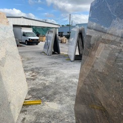
Countertop Geology: Desperate for rocks? Visit a “granite” countertop store!

Where can you see some rocks? It’s winter and everything’s covered in snow –or you’re visiting family in some place where there’s virtually no bedrock exposed anywhere –or you’re simply stranded far from any good rocks in the center of a big city.IP18-0957c

Take yourself on a field trip to a granite countertop store! You might not see very much real granite, but you will see some other types: folded gneiss, pegmatite, amphibolite, quartzite, maybe even some granite… and a lot of amazing metamorphic and igneous features and faults –and they’re all polished and none are covered by vegetation.

I needed a rock fix the other day while visiting my mother in SW Florida –so I drove to a granite countertop store. And wow— I saw all sorts of great stuff, a lot of which related to faulting and fracturing, and a lot of it could go right into a geology textbook. In Florida!

IP18-0947e

Red garnet along with quartz and feldspar in gneiss -a metamorphic rock.

Read more…

Washington’s waterfalls–behind each one is a rock!

Of all the many reasons why waterfalls are great, here’s another: they expose bedrock! And that bedrock tells a story extending back in time long long before the waterfall. This posting describes 9 waterfalls that together paint a partial picture of Washington’s geologic history. The photos and diagrams will all appear in my forthcoming book Roadside Geology of Washington (Mountain Press) that I wrote with Darrel Cowan of the University of Washington.

151107-27flr

Rainbow falls along WA 6 in the Coast Range


And waterfalls in heavily forested areas are especially great because they may give the only view of bedrock for miles around! Take Rainbow Falls, for example–the small waterfall on the left. It’s in Washington’s Coast Range along State Highway 6–a place where a roadside geologist could otherwise fall into total despair for lack of good rock exposure. But this beautiful waterfall exposes a lava flow of the Grande Ronde Basalt, which belongs to the Columbia River Basalt Group. Significant? Yes!

This lava erupted in southeastern Washington and northeastern Oregon between about 16 and 15.6 million years ago and completely flooded the landscape of northern Oregon and southern Washington. We know how extensive these flows are because we can see them–and they cover the whole region. The photo below shows them at Palouse Falls in the eastern part of Washington. Take a look at my earlier blog post about the Columbia River Basalt Group? (includes 15 photos and a map).

Read more…

Rockin’ countertops–geologic time in our kitchens and bathrooms!

I stopped by a “granite” supplier yesterday –the kind of place that sells “granite” and “marble” slabs for countertops.  Besides the fact that almost none of the slabs were actually granite or marble, they were spectacular rocks that showed wonderful wonderful detail. I nearly gushed at the idea of taking a geology field trip there.  It’s local, and you seldom find exposures like this anywhere else!

slabs of polished rock at a "granite" warehouse --not sure if any of this is actually granite, but it all reflects geologic time.

slabs of polished rock at a “granite” warehouse –most of it’s not actually granite, but it all reflects geologic time.

Generally speaking, “granite” in countertop language means “igneous” or “metamorphic” –crystalline rocks that form miles beneath Earth’s surface and so require great lengths of time to reach the surface where they can be quarried.  When I first started this blog, geologic time with respect to igneous and metamorphic rocks were some of the first things I wrote about –it’s such pervasive and important stuff.

So the main point is that your friend’s kitchen with “granite” countertops surrounds you with geologic time every time you walk in there!

But check out that green polka-dotted rock on the right side of the photo.  Full of rounded cobbles –it’s a conglomerate, originating by sedimentary processes on Earth’s surface. Does it indicate great lengths of geologic time? A Young Earth Creationist might say it were a deposit of “the Flood” and end-of-story.

Here’s a closer look:

Polished conglomerate --individual cobbles are metamorphic rocks. The green color comes from the mineral chlorite.

Polished conglomerate –individual cobbles are metamorphic rocks. The green color of the background material comes from the mineral chlorite. That’s a penny (on the left) for scale.

The conglomerate is made of beautifully rounded cobbles and small boulders that are almost entirely metamorphic in origin.  Most of them are gneisses, which form at especially high grades of metamorphism, typical of depths greater than 8 or 10 miles!  After a (long) period of uplift and erosion, the rock was exposed to erosion, gradually breaking into fragments, which eventually became these rounded cobbles, and ended up in the bottom of a big stream channel or on a gravel bar somewhere.

But that’s not the end of the story, because this deposit of rounded cobbles itself became metamorphosed –so it had to get buried again. We know that because the rock is pervaded by the mineral chlorite, which gives the rock its green color.  Chlorite requires metamorphism to form.  Granted, the rock isn’t highly metamorphosed –there’s no metamorphic layering and chlorite forms at low metamorphic temperatures– but it’s metamorphic nonetheless, typical of depths of a few miles beneath the surface.

And if you look even closer, you can see some of the effects of the reburial pressures: the edges of some of the cobbles poke into some of the other ones. This impingement is a result of the stress concentrations that naturally occur along points of contact.  The high stress causes the less soluble rocks to slowly dissolve into the other, more soluble rock.

cobbles, impinging into each other. Stars on right photo show locations.

cobbles, impinging into each other. Stars on right photo show locations.

I’m already jealous of the person who’s going to buy this slab of rock. It tells a story that begins with 1) metamorphic rock forming deep in the crust, then 2) a long period of uplift and erosion to expose the rocks, then 3) erosion, rounding, and deposition of the metamorphic cobbles, 4) reburial to the somewhat shallow depths of a mile or two–maybe more, 5) more uplift and erosion to expose the meta-sedimentary deposit, 6) Erosion by human beings.

And me? Personally, I’d like to make a shower stall or a bathtub out of this rock –can you imagine???


Some links you might like:
a blog I like that’s about science and creationism
another blog about an ancient Earth and deep time
my original song “Don’t take it for Granite“. (adds some levity?)
Geology photos for free download.


Geologic field trip from Yellowstone Lake to Portland, Oregon at 30,000 feet

What a start to the new year!  January 1, I flew home to Oregon with a north-facing window seat on a spectacularly clear day.  So much incredible landscape!  So much incredible geology!  Here are nine photos I shot out the plane window, keyed to the geologic map below.
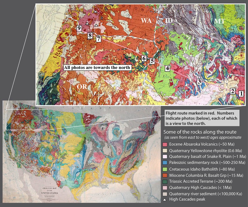
Yel-PDX + US map

Photo 1.  Absaroka Range, northern Wyoming and southern Montana.  You can see that these mountains consist of layered rocks (see bottom of photo especially)–but they’re not sedimentary.  They are basaltic to dacitic lava flows and pyroclastic rocks of the Absaroka Volcanic Field,  erupted from about 53-43 million years ago.  Much of the present topography is the result of glacial erosion during the Pleistocene.
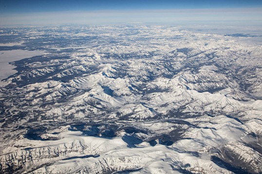
Absaroka Range, east edge of Yellowstone Lake on left.

Absaroka Range, east edge of Yellowstone Lake on left.

Photo 2.  Yellowstone Lake.  As you can see on the map, Yellowstone Lake fills only a fraction of the caldera created by Yellowstone’s Lava Creek Eruption, 600,000 years ago.  Since then, rhyolite lavas, shown in pink, filled in the caldera.  Notice the oval-shaped bay at the end of the lake’s western arm.  It’s called West Thumb, and is a younger caldera that erupted about 150,000 years ago.  It’s a caldera within a caldera!  It’s pretty big too– almost identical in size to Crater Lake in Oregon –but compared to the main caldera, it’s tiny.
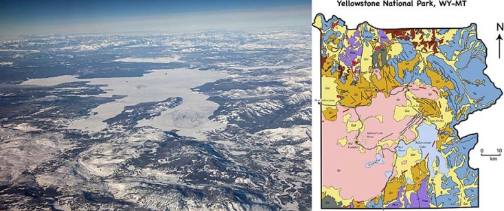
Photo and geologic map of Yellowstone National Park

Photo and geologic map of Yellowstone National Park. The dashed red line marks the caldera edge.

Photo 3. Recent faulting of the Basin and Range Province. In this photo, the Pahsimeroi River flows northwestward to its confluence with the Salmon River, near the left side of the photo –and the Salmon continues flowing northward for about 100 miles before it turns westward and eventually joins the Snake River.
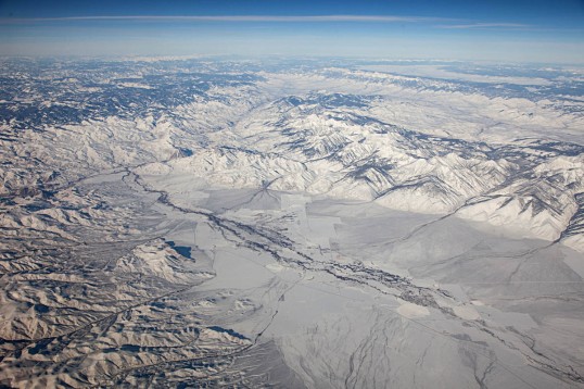
Recent faulting along western edge of Lemhi Range, Idaho.

Recent faulting along eastern edge of Pahsimeroi Valley, Idaho–and western front of Lemhi Range.

But what I think is so cool about this photo is that it so clearly shows the abrupt western edge of the Lemhi Range, which runs diagonally from the right (east) side of the photo to just above the center.  The range literally rises right out of the ground.  That abruptness is caused by faulting that takes place recently and frequently enough that erosion doesn’t keep up with it.  The fault is a normal fault, caused by crustal extension.  Notice the linear nature of the ranges to the northeast (upper right) –More normal faulting!  This is a northern expression of the Basin and Range Province.  Woohoo!

Photo 4. Mountains of the Idaho Batholith.  Granitic rock of the Idaho Batholith underlies a huge area of Idaho, some 14,000 square miles of it. On the geologic map, it’s the big green area.  The rock intruded as a series of plutons during the Late Cretaceous, from about 100 – 65 million years ago.  Similar in age and composition to the Sierra Nevada Batholith, the Idaho Batholith was fed by magma created during subduction along the west coast of North America.

Mountains of the Idaho Batholith

Mountains of the Idaho Batholith

Photo 5. Hell’s Canyon.  Not only does the north-flowing Snake River in Hell’s Canyon form the boundary between Idaho and Oregon (Yay, we made it to Oregon!), and not only is it the deepest canyon in the conterminous United States, but it’s also incredibly important from a geologic-history-of-western-North-America point-of-view.

Notice the flat areas above the canyon–they’re especially visible on the west (left) side, but you can also see them on the east.  Those places are flat because they’re made of flat-lying basalt of the Columbia River Basalt Group. These basalts erupted mostly between 17-14.5 million years ago, but kept erupting off and on until about 6 million years ago –and they cover ALL of northern Oregon and ALL of southeastern Washington State.  In fact, they flowed all the way to the Pacific Ocean.
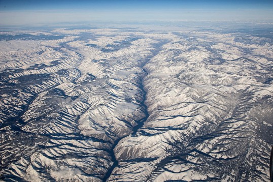
Hell's Canyon and the Snake River.

Hell’s Canyon and the Snake River. The Imnaha River forms the next deep canyon to the left (west).

Those basalt flows overlie rock of the Wallowa accreted terrane: mostly volcanic and sedimentary rock that formed in an island arc setting, far offshore from North America.  It was added (accreted) to the North American continent during the Mesozoic –probably some 150 million years ago.

Photo 6. Wallowa Mountains, Oregon. Just west of Hell’s Canyon are the Wallowa Mountains, Oregon’s premier alpine country outside of the Cascades.  Like Hell’s Canyon, the Wallowas contain the accreted Wallowa terrane overlain by Columbia River Basalt –but the Wallowas also host the Wallowa Batholith, a Jurassic-Cretaceous granitic “stitching pluton”.  It’s called a stitching pluton because it intrudes across accreted terranes and “stitched” them together.

Glacial valleys and frontal fault zone on the north side of the Wallowa Mountains, Oregon.

Glacial valleys and frontal fault zone on the north side of the Wallowa Mountains, Oregon.

You can see a bunch of other things in this photo though.  First off, the mountains end suddenly in a line: a recently active fault zone that has uplifted them more than 5000′ relative to the valley floor. Also, you can see how glaciers carved the landscape.  Notice the deep U-shaped valleys, cirques, and knife-edged ridges called aretes.  And see the lake in the upper right corner of the photo?  It’s Wallowa Lake, dammed by a glacial moraine!

(at this point, the folks in the seats next to me wanted to throw me out of the airplane)

Photo 7. View of Washington High Cascades over The Dalles.  That’s Mt. St. Helens on the left (west), Mt. Adams in the middle, and Mt. Rainier in the far distant right.  Mt. Rainier is 90 miles away!
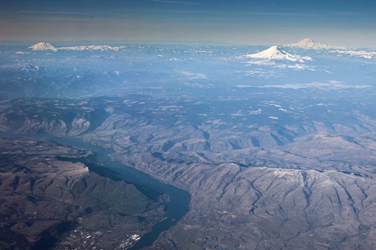
Looking north over the Dalles to Mts. St Helens, Rainier, and Adams.

Looking north over the Dalles to Mts. St Helens, Rainier, and Adams.

These volcanoes are dormant –which means that they’re …sleeping?  And they can awaken at any time.  I remember a college friend of mine wanted to climb Mt. St. Helens in 1979.  It was dormant then, and nobody worried about it.  Then in May, 1980 it erupted violently, blowing off its top 2000′.  Both St. Helens and Mt. Rainier have erupted many times in the past several thousand years; Mt. Adams though, erupted only twice in that period.

Photo 8.  Columbia Gorge, the Washington High Cascades, and the Bonneville Landslide.  From left (west) to right, the volcanoes are Mt. St. Helens, Mt. Rainier, and Mt. Adams.  You can see the Bonneville Landslide along the river on the right side of the photo, directly below the left base of Mt. Adams.  It detached from the cliffs directly behind it about 1450 A.D. and slid right into the river –and it pushed the river about a mile to the south! Just downriver from the landslide, you can see the Bonneville Dam zig-zagging across the river.

View northward over the Columbia River Gorge to the Washington High Cascades.

View northward over the Columbia River Gorge to the Washington High Cascades.

The ridges at the bottom of the photo lead up to Mt. Hood, another dormant stratovolcano and Oregon’s highest peak.  Apparently, the view out the south side of the plane was even more ridiculously cool.

Photo 9. Columbia River, just below Portland.  Right near Portland, the Columbia River turns northward for about 40 miles before it heads west again out towards the Pacific–and it drops only 10 feet in elevation for the whole distance.  The northward deflection of the river is probably the result of uplift of the Portland Hills, which likely began as long as 16 million years ago (they also deflect 16 million year old lava flows of the Columbia River Basalt). That town along the river in the background is St. Helens, Oregon.
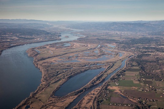
View northward, down the Columbia River.

View northward, down the Columbia River, Washington on the right, Oregon on the left.


See more geologic photos of Oregon by typing “Oregon” into the geology search engine on my website –or type “Oregon, aerial” if you want to see aerial shots!  And if you’re suddenly really excited about Oregon geology, please check out the new edition of Roadside Geology of Oregon!

Cloudy afternoon waving at the Stawamus Chief–lovely spot and deep time

My friend Jessica and I skipped out from the Geological Society of America meeting in Vancouver last weekend to go visit the Stawamus Chief –a gigantic granite monolith near the town of Squamish.  What a lovely place –and what a great respite from the craziness of a big meeting in a big city!

I don’t want to repeat myself too much, because I wrote about this in an earlier post–but just the fact that granite is exposed at the surface requires deep time –inconceivably great lengths of time.  That’s because granite forms from a molten state by slow cooling and crystallizing far beneath Earth’s surface –10 km or more usually –and THAT means the rock had to get uplifted and exposed at Earth’s surface through processes that we humans perceive as time-consuming–on the order of millions of years.  Additionally, all the rock that used to be above the granite had to get eroded away in the process.

Stawamish Chief rises some 2000 feet above us --a trail leads to the top.

And Shannon Falls is right there too–Amazing!  It sprays about 1000′ down a series of cliffs–and allows a good, up-close look at the granite.  It’s actually granodiorite –which is a lot like granite except that it contains a lot more plagioclase, as opposed to alkali, feldspar.

Shannon Falls, near the bottom of its 1000' drop.

Shannon Falls, near the bottom of its 1000′ drop.

So… the granite speaks to great amounts of time… and the waterfall–it speaks to the changing landscape.  It falls down scoured and smoothed cliffs because the whole area has been shaped by glacial erosion.  Not long ago, this area was under ice!  (Longer though, than the beginning of planet Earth according to the Young Earthers).  You can see some wonderful glacial polish and striations on fluted granite along the highway between the Chief and the town of Squamish.

Glacially carved granite--right next to a large pull-out on the highway.

Glacially carved granite–right next to a large pull-out on the highway.


click here for some more photos of intrusive igneous rocks.

Geologic Time in a mountainside –the Wallowa Mountains from Joseph, Oregon

Joseph, Oregon is a wonderful place for geology.  The town sits right at the foot of the Wallowa Mountains in the northeastern corner of Oregon.  The mountains rise some 4-5000′ abruptly from the valley floor along a recently active normal fault.

The Wallowa Mountains rise along a fault zone just south of the town of Joseph.

The Wallowa Mountains rise along a fault zone just south of the town of Joseph.

In the mountains, you can see some bedrock relations that speak to great lengths of geologic time.  An erosional remnant of the Columbia River Basalt Group caps Sawtooth Peak in the photos below; it sits directly on granite of the Wallowa Batholith –and just a little bit south, on the next peak, the granite intrudes Martin Bridge Limestone!  So, from oldest to youngest, the rock units are the Martin Bridge Limestone, the Wallowa granite, the Columbia River Basalt.

Sawtooth Peak (right) capped by Columbia River Basalt.  Beneath it is granite of the Wallow Batholith --and off to the left, are the bedded rocks of the Martin Bridge Limestone.

Sawtooth Peak (right) capped by Columbia River Basalt. Beneath it is granite of the Wallowa Batholith –and off to the left, are the bedded rocks of the Martin Bridge Limestone.  See below for labels.

Rock units and contacts described in the text

Rock units and contacts described in the text

Never mind that we know the Martin Bridge Limestone is Triassic –so more than 200 million years old –and that the Wallowa Batholith formed at different times between 140 to about 120 million years ago –and that the basalt is about 16 million years old.  You can throw out radiometric dating, but even so, you’re looking at a great span of geologic time.  The limestone first had to be deposited, layer after layer –and then buried –and then intruded at a depth of 5-8 km by the granite –which THEN had to get uplifted to Earth’s surface so the basalt could flow over it.  After THAT, it all had to get uplifted to its present elevation along the normal fault just south of town and much of the basalt had to erode away.

Honestly, we have influential people in this country who spout off things like the Earth is only 6000 years old.  They also deny the overwhelming evidence for climate change.  I guess I should stop writing now before I get too worked up!


More photos of the Wallowas at Geologic Photography.

Glacially carved granite in Rocky Mountain National Park, Colorado

This landscape is so smooth and rounded that you can easily imagine the ice that must have covered it some 20,000 years ago.  And the ice must have been deep!  Look halfway up the mountain in the foreground on the left; it shows a distinct change of rock weathering akin to a bathtub ring–and the ring persists around much of the photo.  It likely marks the upper surface of the ice at maximum glaciation.

140809-94
Upper Glacier Gorge, a glacial cirque in Rocky Mountain National Park, Colorado.  View of the Spearhead (left) and McHenry’s Peak (just behind)

Like most landscapes, this one’s pretty young–and those glacial effects are even younger.  When compared to the age of the rock, it seems almost insignificant.  The granite bedrock, which is granite, is 1.4 billion years old!  Elsewhere in Rocky Mountain National Park, the granite intrudes even older metamorphic rock –1.7 billion years old.  Just .3 billion years older.  I think we forget that “just .3 billion years” is 300 million years –about the same length of time as the entire Paleozoic!  And the Pleistocene Epoch, during which the glaciers grew?  It started some 2 million and ended about 10,000 years ago

Granite sill intruding gneiss, Colorado.
1.4 billion year old granite intruding 1.7 billion year old gneiss in Rocky Mtn National Park.


images can be downloaded for free at marlimillerphoto.com

San Andreas Fault

Here’s a view of the San Andreas fault and Pt. Reyes in northern California, looking northward.  The fault runs right up the narrow Tomales Bay–and in just a few miles, runs along the edge of San Francisco.

The San Andreas fault is amazingly well-studied –it’s probably the most-studied fault zone in the world.  After all, it is capable of generating huge earthquakes in heavily populated areas, so the more we know about it the better.

San Andreas fault and Tomales Bay

Aerial view of San Andreas fault and Pt. Reyes --just north of San Francisco. View is to the north. The fault runs down Tomales Bay, the narrow arm of the ocean that runs diagonally across the photo.

One thing we know about the San Andreas is that it generally moves in a side-by-side way (strike-slip) so that rock on the east side moves south relative to that on the west side.  And over time, the fault has moved the eastern rock more than 300km relative to the western rock.

Now, 300 km –that speaks to millions of years of geologic time.  We can measure the rate at which the Pacific Plate moves relative to the North American Plate –about 4.5 cm/year.  The San Andreas takes up most of that –but not all.  But if we assume it takes it all, we’re looking at a total of 300km at 4.5cm/year –so at least 6.6 million years.

Of course… if you think planet Earth is only 10,000 years old, that means the fault’s moved some 300 meters (3 football fields) every 10 years.  And considering that the displacement was about 6 meters during the M 8.3 1906 San Francisco Earthquake…that’s a lot of earthquakes in just a short period of time!

Or another way of putting it, if planet Earth were 10,000 years old AND the San Andreas fault formed at the very beginning, 10,000 years ago… then there must have been 50 of those San-Francisco-sized Earthquakes every ten years –or… 5 of those every year.  Yikes!

But of course… we know that the San Andreas isn’t as old as the planet.  It cuts that granite at Pt. Reyes… which is related to the Sierra Nevada granite –which is really pretty young –but older than 10,000 years by about 100 million.

click here if you want to see more photos of the San Andreas fault –with a map!

Cretaceous batholiths and roof pendants

The photos from the last posting were from the Sierra Nevada Batholith –called a “batholith” because it consists of many many smaller intrusive bodies that collectively define a much larger intrusive complex that doesn’t even have a well-defined root.  As it turns out, the Sierra Nevada are one of several really large batholiths that intruded the crust of the Pacific Margin during the Cretaceous Period, about 80-100 million years ago.

Granitic Batholiths of Cretaceous age in western North America.

And along the east side of the Sierra Nevada, we can see the original rock into which the granite of the Sierra Nevada intruded.  This original rock consists of older sedimentary and volcanic rock–that dates from the Cambrian Period through the Jurassic– much of which was metamorphosed by the heat from the intruding granite.  The photo below shows the Cretaceous granite below (light colored rock) and the dark-colored sedimentary (now metamorphic) rock above.  These older rocks that are intruded by the granite are called “roof pendants” because they show the roof of the batholith.

Cretaceous granite intruding Cambrian metasedimentary rock, Sierra Nevada Range.

And as far as geologic time goes, this photo shows us that the granite, discussed in previous posts, is younger than the sedimentary rock that overlies it.

And click here to see a photo of glaciated granite in Yosemite National Park.


Igneous Rocks

Here are some samples of different igneous rocks.  The upper photo shows intrusive igneous rocks and the lower photo shows volcanic (extrusive igneous) rocks.

From left to right, these rocks are arranged in order of decreasing silica content: granite, diorite, and gabbro. Click here for more photos of igneous rocks and features.

I can’t claim that these are the most artistic photos, but they do show a couple things about igneous rocks.  First off, to be igneous, a rock needs to have cooled and crystallized from a molten state.   Intrusive rocks, shown in the photo above, are the type of igneous rock that cools and crystallizes within the crust; volcanic rocks, shown in the photo below, cool and crystallize on the Earth’s surface.  Because they form by cooling and crystallizing, crystals in both types  generally have a random orientation and an interlocking texture.  You can see that in the photo above, because intrusive rocks tend to be coarse grained.  It’s much harder to see that feature in volcanic rocks because they tend to be fine grained.

Intrusive igneous rocks are coarse-grained, and volcanic rocks are fine-grained because it takes time to grow crystals –and intrusive rocks take longer to cool and crystallize because they’re insulated by the surrounding rock.

These photos also demonstrate how igneous rocks generally become lighter in color as their silica content increases and their iron content decreases.  By definition, granite (left photo) has more silica than diorite, which has more silica than gabbro.  Iron tends to follow silica in an inversely proportional sort of way –so the gabbro has the most iron.  Same thing with the volcanic rocks.

When it comes to great lengths of geologic time, the intrusive rocks are the most instructive.  They form within the Earth– at depths of several kilometers to several tens of kilometers –but here are some hand samples at the surface?

So the big question is, how long does it take for a rock at a depth of say, 10 km, to make it to the surface of the Earth?  It depends on the rate of uplift and erosion –but really fast uplift rates are on the order of 1 meter/thousand years.  That makes for 10 million years at minimum just to get these little hand samples to the surface!

From left to right, these rocks are arranged in order of decreasing silica content: rhyolite, andesite, basalt. Click here for more photos of volcanic rocks and features.

Post Navigation