I’ve long been drawn to Death Valley. As a geologist, I can’t think of a better place to witness the incredible geologic history that shaped western North America –and as a photographer, I can’t think of a better place to capture images of what’s a mind-boggling array of geologic features.
To that end, I recently completed a book called Death Valley Rocks! A guide to geologic sites in America’s hottest national park. It’s being published by Mountain Press and should be out in early July. The book covers 40 geologically amazing sites in the national park as well as the adjacent Amargosa Valley and will be full of color photos and maps –and (of course) many of my photos didn’t make the cut. Here are twelve of those outtakes, selected to present a general picture of Death Valley’s geology. You can click on any image to see it at a larger size.
The first photos reflect Death Valley’s modern setting, an actively evolving basin in the southwestern part of the Basin and Range Province. The valley is the terminus of the Amargosa River, shown as the heavy dashed blue line resembling a giant fishhook in the map. The river starts just north of Beatty, Nevada, and flows southward about a 100 miles through the towns of Shoshone and Tecopa before turning northward to empty into Death Valley. Without an outlet, all the water that reaches the floor of Death Valley stays there until it evaporates. As it evaporates, the water precipitates salt, producing a magnificent salt pan that is broken by myriad polygonal shrinkage cracks.
I’m hiking up a closed road in Death Valley National Park to see a pile of gravel. I guess that’s one way to look at it. What some folks might view as a waste of precious time in this magnificent place I see as a vehicle for time travel.
Gravel ridge along the Beatty cut-off road in Death Valley was deposited as a spit near the shoreline of Glacial Lake Manly. The highway cuts right through the center of the spit.Two smaller spits are visible on the far right side of the image. (photo 240106-97)
Just 4 months ago in August, Hurricane Hilary dropped some 2.2 inches of rain on Death Valley—more than what typically falls here over the course of a year. With virtually no soil to absorb it, the water ran off immediately. It gathered in rivulets, confluenced into small channels, then larger channels, and finally streams that flash-flooded down canyons and alluvial fans. The flooding closed every road in the national park. It’s now early January, 2024 and this road up one of the fans isn’t supposed to open to cars for another two weeks.
In just under two miles, I reach my destination, a low ridge extending eastward from the base of a hill. It was deposited by waves near the shoreline of a giant lake called Glacial Lake Manly, sometime between186,000-120,000 years ago. The ridge grew by fits and starts out from the hill as a spit, with waves obliquely slapping its front and moving the gravel out to its tip. You can see wave-rounded cobbles in the roadcut forming curved layers that slope towards the valley. They’re also scattered about on the top of the spit where I sit down and take in the view.
The highway cuts right through the spit. Death Valley, once filled to a spot above and behind the spit, is in the background.(Photo 191101-75)
In front of me, the highway descends its gentle gradient to where I parked the car, nearly 200’ below sea level. From there, the floor of Death Valley is practically flat, continuing well past Badwater Basin some 25 miles to the south. When this gravel spit formed, Lake Manly, more than 50 miles in length and some 6-8 miles wide, filled the entire scene. At its high stand, I’d be below water because the lake’s highest shoreline reached another mile up the road. The gravel spit formed as the lake receded. Two smaller ridges lie just below where I sit and another very small one lies just above, marking different stages in its retreat.
Just like anybody, I wrestle with the ever-changing and fluid concept of time. Stopped highway traffic that delays my arrival by 15 minutes can seem interminable and I bemoan how quickly a year passes. I’ve heard countless people comment at how Badwater Basin is still flooded by water from Hurricane Hilary but when it all finally evaporates, we’ll probably describe the shallow lake as short-lived. This remnant of a giant lake that existed over 100,000 years ago takes my confusion to a new level. Was that a long time ago?
It seems so, but then I think of the mountains that enclosed the lake. They started rising some 3-3.5 million years ago—more than 20 times the age of the lake. I’ve always considered the mountains to be young, even going so far as to tell park visitors that Death Valley’s present landscape was “only about 3 million years old”. Compared to their rocks, many of which are older than 500 million years, that’s true. Some of the rocks are well over a billion years old.
Those rocks tell stories –about how they formed and about what’s happened to them since. I pick a cobble up off the spit. It’s a beautiful maroon color and made of tiny grains of quartz all mushed together. I suspect it came from the Zabriskie Quartzite, a distinctive rock unit that forms prominent cliffs throughout the region. Its sand was deposited mostly in a shallow ocean and various coastal environments during the Cambrian Period, which lasted from 539-485 million years ago.
Overturned Anticline in Titus Canyon–the Zabriskie Quartzite forms the prominent red cliffs in the right-center of the photo. To the left (west) is overturned Cararra and Bonanza King Formations. At the canyon mouth, the rocks are nearly horizontal, yet upside down. (Photo SrD-10)
I’ve studied geology my entire adult life and I still find it incredible that I can hold, in my own hands, a piece of the Cambrian sea floor. Each of the millions of tiny sand grains that make up this rock originated from some still-older rock and were transported by streams to the Cambrian shoreline. There, they were probably kicked around by coastal waves until getting buried by layers of more sediment, followed by more sediment for who knows how long –until circulating groundwater cemented the compacted grains together as layers of rock. In the Death Valley region, there are more than 10,000 feet of sedimentary rock on top the Zabriskie Quartzite and at least another 10,000 feet of sedimentary rock below. Each bedding plane in that sequence of rock was once the Earth’s surface.
And so much has happened to them since! Besides today’s mountain-building, driven because the earth’s crust in the region is extending, they’ve all experienced an earlier period of mountain-building by crustal compression. At the mouth of Titus Canyon just 20 miles northwest of here, those events folded the rock to where the sequence is completely upside down. Elsewhere, the rocks were intruded by granitic magma, while others were carried to depths of 15 miles or more and partially melted. And now, as today’s mountains erode, they shed rocks of all ages and types and sizes into their canyons, which get washed out onto the alluvial fans during floods.
From my perch on the gravel spit, I’m just a few feet above the alluvial fan. It’s unmoving and silent. The road will reopen soon, and tourists will once again drive past this spot without a second thought. But the myriad channels and wild assortment of rocks of the fan speak to a process that never stops. It will flood again. I see the whole fan in motion, with gravel streaming over the road, tearing up the asphalt, eventually burying or eroding the gravel spit. Today, this year, my existence—they all seem to diminish into the infinitesimal. I close my eyes and start walking downhill, deeper into the lake.
This essay came about from researching my forthcoming book: Death Valley Rocks! Forty amazing geologic sites in America’s hottest National Park, to be published by Mountain Press. (Sept, 2024)
Each photo (and >5000 more) is available for free download from my photography site, geologypics.com –just type the description or stock number into the search.
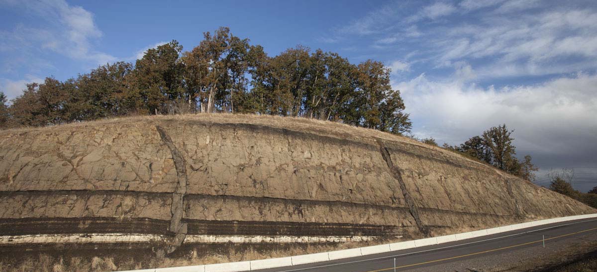
You don’t see many rocks where I live in western Oregon. Lush forests or savannah-like areas dotted with Oak, yes, but the bedrock mostly lies beneath the vegetation and a thick mantle of soil. Just south of town though, the highway cuts through a hillside to expose rock that reminds us of our geologic setting –and taken in context, points to Earth’s incomprehensibly long history.
I’m standing in a soft rain at the foot of the roadcut, looking upwards at some 50 feet of strata. The rocks are sedimentary, having been deposited in lakes and rivers, but there’s also a thin layer of light-gray ash near the top of the cut and a much thicker one near the bottom –and slashing vertically through everything are two narrow gray, almost black, bodies of igneous rock. Called dikes, they worked their way upwards as molten rock along cracks in the older sedimentary rock before cooling and crystallizing where they are now.
Highway Roadcut near Eugene, Oregon
Evidence of ancient volcanic activity abounds: ash, dikes, even the sedimentary rocks are made mostly of volcanic particles. And on clear days, I can walk to the south side of the roadcut and look eastward to forested ridges of the Western Cascades that give way in some 50 miles to the snow-capped peaks of the High Cascades. They’re all volcanic. The High Cascades volcanoes are young and active whereas those of the western Cascades are long extinct and deeply eroded. Combined, the two parts of this range formed over a period of about 40 million years and produced miles and miles of lavas, ash and debris flows, and volcanic-rich sedimentary rocks.
Trying to imagine this 40 million-year history is like watching the stars, filling me with wonder and leaving me humbled, subdued, and exhilarated, all at the same time. And by geologic standards, 40 million years isn’t extremely long. Death Valley, California, one of my favorite haunts, showcases some 30,000’ of sedimentary rock that was deposited over a period of 400 million years, between about 700 and 300 million years ago –and beneath them lies rock that records conditions on Earth’s surface over a billion years ago. Anyone can see these rocks, touch them, and imagine the incomprehensible.
Paleozoic strata in Death Valley
When I was in college, I encountered a textbook passage that helped me visualize geologic time. The author, Don Eicher of the University of Colorado, imagined Earth’s entire 4.54 billion year history compressed into a single year. He pointed out that, in this calendar, Earth’s first organisms would’ve lived sometime in late March, the first creatures that produced shelly fossils appeared November 17, and the first land plants around November 23. He included many noteworthy events, but they didn’t include the Cascade Range. By my calculations, the 40 million years of Cascade volcanic activity existed for about the last three days of this calendar year. The first humans? They appeared about 35 minutes before midnight.
It boggles the mind to think about how much humans have done in those 35 minutes, so much so that we’re considering naming a geologic period of time after ourselves: the Anthropocene. It’s likely that we’d designate it an “epoch” so it would naturally come after our present epoch, the Holocene, which followed the Pleistocene (Ice Age), which followed the Pliocene, and so on. Of course, any formal designation would require people to agree on exactly when it began and for that there is little consensus because humans caused major changes on Earth at different places during different times. The one time most researchers agree affected everywhere at once was the widespread atomic weapons testing in the late 1940s and 1950s, which spread radionuclides across the planet and are now an identifiable part of the sedimentary record.
Folded mylonitic gneiss, Death Valley, California
Without question, humans are an indomitable geologic force, especially since the early 1950’s. It’s no wonder many researchers call that time “The Great Acceleration”, when our technology and energy use increased exponentially. And less than 40 years later during the 1990s, we recognized that our activities move more material each year than any other natural force such as rivers or landslides or glaciers. Since then, our “bioturbation” has only increased. We have colonized every habitable nook and cranny on this planet and are precipitating environmental catastrophes we’re only beginning to comprehend.
But to call this human time period a geologic epoch seems to imply a certain longevity to both the period and to its trademark origin: Homo sapiens –and since 1950, the earth has aged barely a half second in its year-long calendar. I wonder how much longer we can last. To me, the concept of the Anthropocene as an epoch seems contingent on us surviving our environmental crises and continuing for thousands of years. After all, the Holocene Epoch, which it would replace, lasted for 10,000 years, and all the epochs before lasted millions. Instead of a new epoch, we may instead be in a transitional period from the Holocene to something that postdates Homo sapiens. If that’s the case, then we’re witnessing more of dramatic event: mass extinctions and environmental changes that will herald an altogether different ecosystem.
I reach down at my feet and untangle a wet plastic bag from some rocks that have fallen from the roadcut. So different, yet both pieces of sediment just the same. Both may find their way into the rock record. I wonder how our part of the record will appear long after our time has passed. I imagine we’ll be a readily identifiable layer, thick in some places and thin in others, and everywhere representing the same moment in time. It won’t be an epoch, but a fleeting second or two in Earth’s year of ages.
inside the crater of Mt. St. Helens (click on images to see them at full size)
Terminus of Crater Glacier, Mt. St. Helens, Washington
There’s a glacier in the crater of Mt. St. Helens—and unlike most other glaciers, it’s growing. Shaded by soaring crater walls and continually replenished by snow avalanches and rockfalls, it oozes forward more than 100 feet per year. At the sound of a loud crack, I look up at its steep front to see a bunch of rocks breaking free of the ice and tumbling downwards to rejoin their compatriots at the bottom. Soon, the ice will advance over them and they’ll be a part of the glacier again.
I’ve long been attracted to these landscapes, practically devoid of organic life but alive just the same. They evoke a sense of timelessness, a connection to Earth’s past, long before mammals and reptiles, let alone humans, colonized its surface. Besides this glacier, near-continuous rock fall and rising dust plumes, there’s a 1000’ tall lava dome that still puts out steam. Younger than many teenagers, the dome formed as sticky silica-rich lava extruded from a vent in the crater floor. It rose to within 800 feet of the highest part of the rim over a period of 5 years, from 2004-2008. It now towers over an older dome, which grew from 1980 until 1986, scarcely middle-aged by human standards.
Crater domes and fumarole emissions. The dark ledge across the bottom of the photo marks the terminus of Crater Glacier.
My group is taking its lunch break. One person’s off shooting photos, a few are talking quietly, another’s inspecting some of the pumice and broken rocks that blanket this part of the crater. Our guides are conferring over our route. I feel lucky to be here, having been invited a few months ago to accompany the group to talk about the geology. The Mt. St. Helens Institute, the non-profit that organized the trip, does so under a special use permit from the Gifford Pinchot National Forest.
Looking northward to Spirit Lake and Johnston Ridge, I see a landscape of somber browns, yellows, and grays, decorated with greens. Most of those colors come from rock, either ancient bedrock or eruptive products from the big eruption in 1980. The greens though come from vegetation that is rapidly covering the lower elevations. On the way here, we walked over ashy fields spotted with prairie lupine, paintbrush and a host of other wildflowers I couldn’t identify, small stands of juvenile Douglas Fir and through the occasional jungle of alder.
View northward from the crater entrance to Spirit Lake and the eastern edge of Johnston Ridge.
Almost nothing in my view was spared the effects of the 1980 eruption. At 8:32am, May 18, a magnitude 5.1 earthquake caused the bulging north side of the mountain to fail as a gigantic avalanche, releasing pressure on the magma within the volcano, which naturally expanded northwards at supersonic speeds. Entire forests blew over in the scalding hot gas. 10 miles from the crater and forty years later, you can still see many of these trees lying down in formation, just like toothpicks. The failed north side of the mountain, all .67 cubic miles of it, ranks as the world’s largest debris avalanche in recorded history. I can see its path, marked by giant piles of rock called hummocks. Even here in the crater are deposits of the debris avalanche, forming towers of conical pointed hills more than 100 feet high.
Hikers and landslide hummocks in the crater of Mt. St. Helens, Washington.
I stoop down to look at a small plant. It’s all by itself, growing between loose, rounded pieces of pumice and undoubtedly rooted in more of the same. An early colonizer. If the crater floor were to remain undisturbed, more vegetation would creep in and eventually, this place would become lightly forested like other places nearby at this elevation. Of course, that’s unlikely here, with an advancing glacier and all the rocks falling from the rim.
Or more eruptions! Mt. St. Helens is, without question, the most active volcano in the Cascade Range, with more than a dozen smaller eruptions since the big one on May 18. And long before 1980 there were hundreds. The US Geological Survey closely monitors Mt. St. Helens’s ongoing activity as well as its geologic past to understand the volcano’s behavior through time. They define its history in terms of four distinct eruptive “Stages” that stretch back some 275,000 years. The most recent of these, the Spirit Lake Stage, started about 3900 years ago and is further divided into six eruptive “Periods”, each marked by multiple eruptions and separated by times of dormancy. One of these eruptions, between 3500-3300 years ago during the Smith Creek Period, dwarfed the 1980 eruption. And in the early 1480s, two eruptions of comparable size to the one in 1980 occurred just two years apart.
Shading the sun from my eyes, I look southward to the volcano’s rim, and I can see a whitish layer produced by these two eruptions. It’s called the “W Tephra”. More than 250 feet of rock now sits above it –all formed after 1480. And there used to be 1300 feet of rock above that, until it was blasted off in 1980—which means that in 500 years, Mt. St. Helens grew more than a quarter mile in height. Just before its cataclysmic eruption, its summit stood 9,677 feet above sea level.
Dacite domes and Crater Glacier in crater of Mt. St. Helens, Washington. The W Tephra forms the light-colored band at the end of the arrow.
It’s the myriad smaller eruptions that cause a volcano to grow, and in the case of Mt. St. Helens, they mostly produce lava domes instead of lava flows. As a college student, I had the hardest time visualizing a lava dome because the photographs I saw just looked like gigantic piles of broken rock. But that’s basically what they are, gigantic, dome-shaped, piles of rock. Imagine lava that is so viscous it can hardly flow, oozing out of a volcanic vent, and pushing aside or piling on top of earlier extruded lava, and cooling and breaking up in the process. By its very nature, silica-rich lava like the dacite of Mt. St. Helens is highly viscous. Silica molecules bond with each other to form interconnected networks, so the more silica in a lava, the more viscous it tends to be. Lower silica lavas like andesites contain fewer of those networks so they’re more likely to produce lava flows. Basaltic lavas contain even less silica and flow even easier.
Feeling a gentle breeze, I close my eyes and imagine this place sometime in the future. Two hundred years? Five hundred years? I picture the crater walls, slightly lower now, having steadily eroded through time, their debris gradually filling the crater. A couple large landslides have removed large fractions of one of the walls and piled their debris up against today’s modern domes. During this time, the mountain was largely dormant, but now a pulse of basaltic magma is working its way towards the surface, intruding the gray dacite domes along fracture surfaces as black basaltic dikes. Some of these dikes break through the top of the domes and spill out as basaltic lava flows, which flow a short way down and out of the crater. Mt. St. Helens awakens again, but this time, the lava is basalt so it awakens quietly.
I remind myself that this volcano hasn’t produced much basalt during its 275,000-year history. It doesn’t tend to “awaken quietly”, but more like some grumpy person who you’ve roused with a splash of ice water. Besides the numerous domes, its products typically depict violence: deposits of fallen ash or pumice, or pyroclastic flows, which consist of fast-moving ash, pumice and rock fragments mixed with hot gases. The only basalt lavas from Mt. St. Helens erupted during the end of the Castle Creek Period, which stretched from about 2500 to 1900 years ago. Ape Cave, the lava tube on the volcano’s south side, formed in these lavas, as did the steep rocky slopes we climbed on our hike into the crater. And there, low on the east crater wall, I can see the drama: black Castle Creek dikes slicing through light-colored rock of an older dacite dome. They’re overlain by dark-colored Castle Creek lava flows likely fed by the dikes below, just like my daydream.
Basaltic dikes of the Castle Creek Period cut an older dacite dome. Pyroclastic flow deposits form the layered materials near the bottom of the photo in shadow.
As we start our descent, I reflect on the ongoing Modern eruptive period. Before the first earthquakes on March 16, nearly everyone in the Pacific Northwest viewed Mt. St. Helens as a perfectly symmetrical and docile ice cream cone of a mountain. My college friend Michael longed to return home to Portland for long enough to climb it, partly because it offered such a wonderful glissade after summiting. Then less than two weeks after those first earthquakes, the first steam eruptions began. Then more earthquakes. Bulging of the northern edifice. Steam. Earthquakes. May 18.
We’ve learned so much since then! We’ve watched the Modern Period unfold with our own eyes as well as with a vast array of ever-evolving instruments. We can see the rich details of the volcano’s behavior to the point that researchers divide the last 40 years into two subperiods, defined by the formation of each lava dome. We’ve watched Crater Glacier evolve from a snowfield to a full-on glacier that itself has experienced major changes in its shape and behavior. We’ve watched the crater rim erode. We’ve watched vegetation recolonize a landscape that was suddenly rendered devoid of nearly all organic life.
Loowit Falls and debris avalanche deposits.
Our group stops for a quick break at Forsyth Spring to absorb the flourishing willows, alders, and sounds of running water. I contemplate the earlier phases of Mt. St. Helens, reaching back to its origin as a series of lava domes 275,000 years ago. Those phases must have been as interesting and diverse as today, but we can experience them only through whatever preserved evidence we can find in the volcano’s deposits. We can’t taste the water or feel the freshness of new growth. Still, we can imagine it.
For this reason, I don’t think of today’s Mt. St. Helens as being “reborn” as it’s so often described. Sure, the vegetation is returning, but I can’t help but see it as incidental to the overall story of a volcano that’s always in transition. The 1980 eruption wasn’t an end point or a beginning –just an event that happened during a long eventful history. We’re experiencing just another moment, another transition, in this volcano’s cycle of life.
Something different here: an essay I wrote about teaching field geology on public lands– published under the same title in the March, 2021 issue of Desert Report with a few extra photos added (please click on the photos to see them larger). I guess I’m hopeful –even optimistic– that I’ll be able to teach field camp again this summer! ******************
Six pairs of eyes stared blankly at me. Cows. Amazing how big those creatures are, especially when you’re sitting on the ground so I was grateful they hadn’t already tried to share my tiny bit of shade. I stood up, shouldered my pack, and walked into the bright sun.
Folded Triassic rocks of the Dinwoody Formation
I’m in southwestern Montana, teaching a field geology class. It’s public land, a place I bring my students year after year without fear of locked gates or fences. Besides the great geology, we see awesome views in all directions, innumerable cacti, wildflowers, and sagebrush, occasional wildlife, and of course, cattle. But we come for the rocks: layer after layer, deposited as seafloor sediment, coastal dune, or river gravel over a period spanning some 300 million years. We’re in what’s called the Rocky Mountain Fold-Thrust Belt, where the layers show twists and turns you can’t imagine, and fault zones that caused mountains to rise long before the present landscape even began to form.
And because the area’s managed by the Bureau of Land Management, we can go pretty much anywhere and everywhere over this 3 or 4 square mile area, just like the cows. Each student creates a detailed geologic map. They identify the rocks, draw lines on their maps to show the boundaries between different rock units, and use their maps to interpret the geologic history. It’s difficult work and highly rewarding ‒ and most students complete the course with a new-found sense of confidence and competence.
Students and thrust faults in Triassic LImestone and shale
I spot some students on a nearby ridge and veer off the gravel road to meet them. The sagebrush near the road is high, but as the slope steepens, it gives way to grass and ledges. On cresting the ridge, I call out:
“How’s it going?”
“Okay” one of the students replies. We look at each other stupidly. I have no idea who it is.
“Hope you’re having a good day!” I say cheerfully and walk on.
These students aren’t mine. They’re from one of the many other universities that come here to teach field geology skills. With so many students tramping over this landscape every summer, following existing paths to key outcrops or creating their own, breaking pieces off the bedrock so they can inspect fresh surfaces, I sometimes worry that we might love this place to death.
I feel a slight cooling breeze and sit down. In front of me, the rocks form a rounded arch shape ‒ a product of crustal compression that built mountains here some 80 million years ago. The frustration of chasing down the wrong students morphs into gratitude. I think of the many students who’ve told me, years later, how much they learned here and how much it shaped their careers. Many describe how blending physical exertion with their academic backgrounds led to a sense of discovery they’d never before experienced.
I watch a pickup truck approach the cows down on the road. It slows briefly to pass by and then continues up the gentle grade. Multiple use ‒ that’s the BLM mantra. Besides grazing and wandering geology students, this place is open to energy development, timber harvesting, and all sorts of recreation. By comparison, our impact is small ‒ and the geology here will outlive all of us, no matter how many cattle trails we follow, or create, or how many outcrops we hammer. I’m grateful for our freedom to wander, pursuing education anywhere and everywhere here, and to arrive anytime without having to fill out any kind of paperwork.
****************************
Ten days later, I’m sitting on a block of limestone, listening to water cascade over some ledges before coalescing into a narrow stream. Above me, soaring cliffs of Helena Dolomite form the headwall to the once mighty Grinnell Glacier. Some of the glacier persists high up in this cirque, but the retreat has been so rapid and recent that the glacial scratches across the bedrock are still fresh. Two of my students sit silently, gazing upwards to the headwall. Another studies a rock with a hand lens. Two others slowly make their way towards my perch.
Glacier National Park hosts a vast wilderness of landforms designated by glacial terminology: peaks called horns, ridges called arêtes, cliffs called headwalls, bowl-shaped valley heads called cirques, rock-bound lakes called tarns, deep U-shaped valleys called U-shaped valleys ‒ all carved by glaciers into this amazing bedrock. I ponder what this place must have looked like 15,000 years ago when glaciers were at their maximum. The peaks and some ridges would be recognizable but the valleys between them would be filled with ice that extended in long strands to the edge of the Great Plains.
One of my students practically shrieks with excitement. I’ve been waiting for this: they found the stromatolites, fossilized algae ‒ Earth’s oldest easily visible life form. Resembling an onion in cross-section, these thin concentric layers of rock formed when dome-shaped bodies of algae in shallow clear water trapped sediment as they grew. The ones here, which reach a meter or more in diameter, are the largest and most dramatic I’ve seen.
I watch the other students hurry over as the contemplative mood lights into a spontaneous revival. One student starts laughing. Another exclaims, “Look at this one!” another says, “Oh God!” another: “And the glacial striations go right across them!” Another turns to me quizzically: “How old are these rocks?”
I smile. “I just read that they were all deposited between 1.4 and 1.47 billion years old ‒ so somewhere in there.”
Another question: “And these glacial striations, maybe 10 or 15,000?”
I keep smiling. This spot is one of my all-time favorite places. We hiked the five miles up here for sunrise and now, mid-morning, still have the place to ourselves. The landscape is so fresh and raw ‒ so untouched ‒ that we feel a primeval kinship with this rock and ice.
I finally answer. “Or younger. This place was under ice just thirty years ago. There’s still some glacier left, just across the lake. So much change, huh?”
Many of my students have visited national parks before, but this is the first time they’ve come as geologists. They now see things through the lens of geologic time and process ‒ and for the first time, they are applying their knowledge to a landscape that not only surrounds them, but is beautiful and pristine. They learned important skills earlier in the course on BLM land and here they combine those skills with their human spirits.
We cross the stream and start picking our way up the ledges on the other side, finding more stromatolites as we go. I hear my students talking about landscape and time. Like me, they can relate to today’s landscape, and can imagine the scene during the glacial maximum some 15,000 years ago, but the shallow inland sea in which these rocks formed seems beyond comprehension. Its age, about 1.4 billion years, makes it all the more inconceivable. And what does the word “about” mean in this context anyway? If the rocks formed 1.41 instead of 1.40 billion years ago, they would be a full ten million years older. As geologists, we bandy these ages around with comfort, but when we really think about it, we can’t comprehend 10 million years, let alone a billion.
Upper Grinnell Lake and Helena Dolomite
I stop and consider a series of stromatolites in front of me. They’re exposed on both the front and upper sides of the ledge, giving three-dimensional views of their mounded shapes. Weathering and erosion rounded off many of the broken edges, accentuating the stromatolite’s appearance. For a second, I think I can see them breathe.
Our little group falls silent as we watch a rain squall farther down the valley. What a vast open-air cathedral we’re in! Public lands, be they national parks or forests or open BLM land, house these wonderful places and welcome everyone who will make the journey.
To see more geological photos from from SW Montana or Glacier NP, please see my geology photo website, where you can use keywords to search among >4000 images and download them for personal or instructional uses for free.
All told, we humans have discovered more than 5000 mineral types. I challenged myself to list the five most important minerals when it comes to the formation of rocks and their subsequent weathering and erosion into landscape.
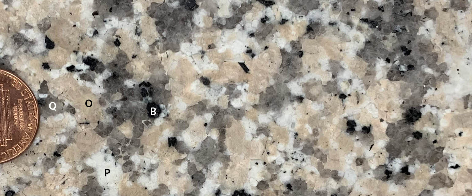
Rock, which makes up our planet, consists of different minerals. This granite is made of, Q=quartz, O=orthoclase feldspar, P=plagioclase feldspar, B=biotite mica (IP18-1012ce)
It’s an impossible task –and subjective, of course –and I fudged a bit by grouping some minerals together. But here they are: the silicate minerals quartz, mica, feldspar, and mafic minerals, and the carbonate mineral, calcite. I invite you to take me to task in the comments section. Even so, these five minerals are easy to identify and are critical to any discussion about rocks –which makes them important to understanding weathering and erosion. And, I’m adding them to my already packed curriculum for my introductory class on surface processes next term, so five seems to be a good upper limit on the numbers.
Oh! Click on any image to see it enlarged on a separate page.
The five awesomest minerals
Weathering, by the way, is the in-place physical and/or chemical breakdown of rock; erosion is its removal –so they go hand-in-hand. A lot goes into how susceptible a rock is to these processes—not just the mineral content—and when it comes to chemical breakdown, the main factors always involve water. If a rock is accessible to water, it will break down more quickly; if it’s not accessible to water, it will be more resistant.
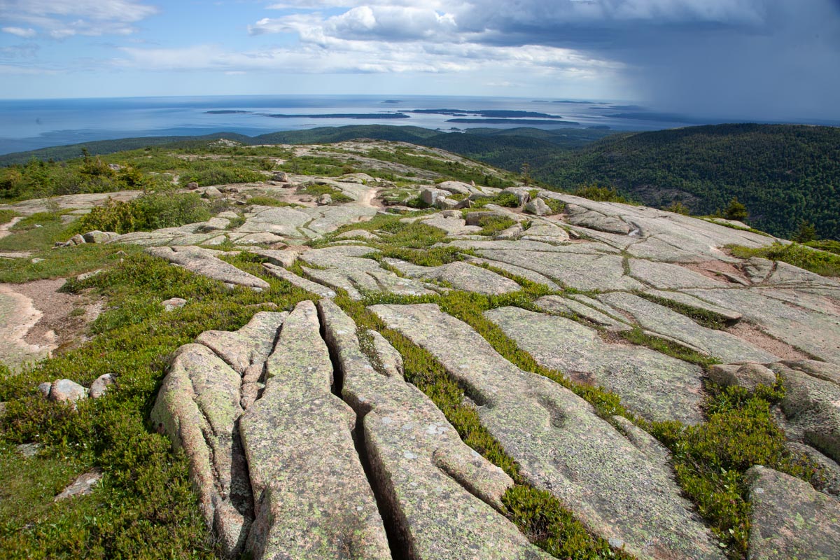
Fractures in granite collect water and host vegetation, focusing weathering along the fracture. Acadia National Park, Maine. (100608-59)
Because some rocks will weather and erode more quickly than others, landscapes form with cliffs and valleys and steep slopes, gentle slopes –all sorts of variation you can imagine—depending in part on the bedrock. We call the phenomenon “differential erosion”. You can find more detail on the processes in one of my earlier posts, called “Shaping of Landscape“.
Differential weathering and erosion: Mexican Hat, Utah (9OtR-049)
Ok… the minerals:
Quartz –most people have come to know quartz because of its pretty crystals –especially the purple variety called amethyst—but they might not realize that it’s a hugely important component of many igneous, metamorphic, and sedimentary rocks, and it forms the cement of many sedimentary rocks. When it comes to weathering, quartz is practically inert chemically, so a strongly quartz-cemented sandstone will be more resistant to weathering and erosion than most other sedimentary rocks. The sandstone will stand out in relief, likely as cliffs or even overhangs. By contrast, weakly cemented, often finer-grained rocks tend to form slopes or even valleys.
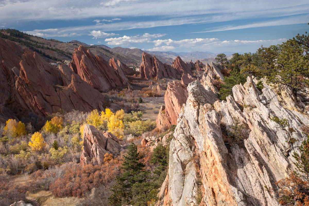
Differential erosion along the Front Range of Colorado: resistant, inclined sandstone beds form ridges while intervening shale forms a valley. (131025-52)
If you look closely at a sandstone like the one below, chance are you’ll see mostly quartz grains. Quartz grains might break up into little pieces as they’re being transported by rivers, for example, but they won’t turn into clay like most other minerals. The result? Sediment gets increasingly rich in quartz the farther it’s transported from its source –and so if it travels a great distance, quartz is just about the only thing left!
Close-up views of quartz sandstone and cement. Photo on right is enlarged approx 3x. (click on it to see it even larger) Nearly all those little sand-sized particles are quartz! (201120-10i)
And if you’re one of those people who really love this mineral, check out this post by Roseanne Chambers, which is all about quartz!
Micas are those shiny sheet-like minerals we see catching the light in a whole host of rocks. The best known micas are muscovite (white mica) and biotite (black mica). In metamorphism, they grow larger with increases in temperature, providing a handy way to distinguish between slate, phyllite, and schist — a nice thing to know in a geology class. The diagram below illustrates the process.
With increasing temperature, the clay within shale will recrystallize to microscopic mica to make slate a hard, metamorphic rock with a dull luster. Even hotter and the micas grow larger to produce phyllite, which has a reflective sheen, and then become easily visible in schist. Hotter still and coarse minerals segregate into layers to make gneiss. (201119-12e)
When it comes to weathering and erosion, those little mica sheets allow infiltration of water. Metamorphic rocks overall are pretty resistant because of their crystallinity –but slates or schist, for example, degrade much more quickly than gneisses because of their prevalence of mica minerals, which together create a fine-scale layering in the rock. Gneisses are coarse-grained, and their layering tends to be thicker and less permeable.
Collectively, feldspars are the most common minerals of the Earth’s crust –and there are numerous varieties, the most common being orthoclase and plagioclase, which often occur together. For the purposes of landscapes, I grouped them together as one: they’re all kind of chunky looking and are generally light-colored. Feldspars are the main components of igneous rocks, making up 60-70% (or even more) of most granitic rocks, which tend to form distinctive landscapes marked by cliffs and large rounded boulders.
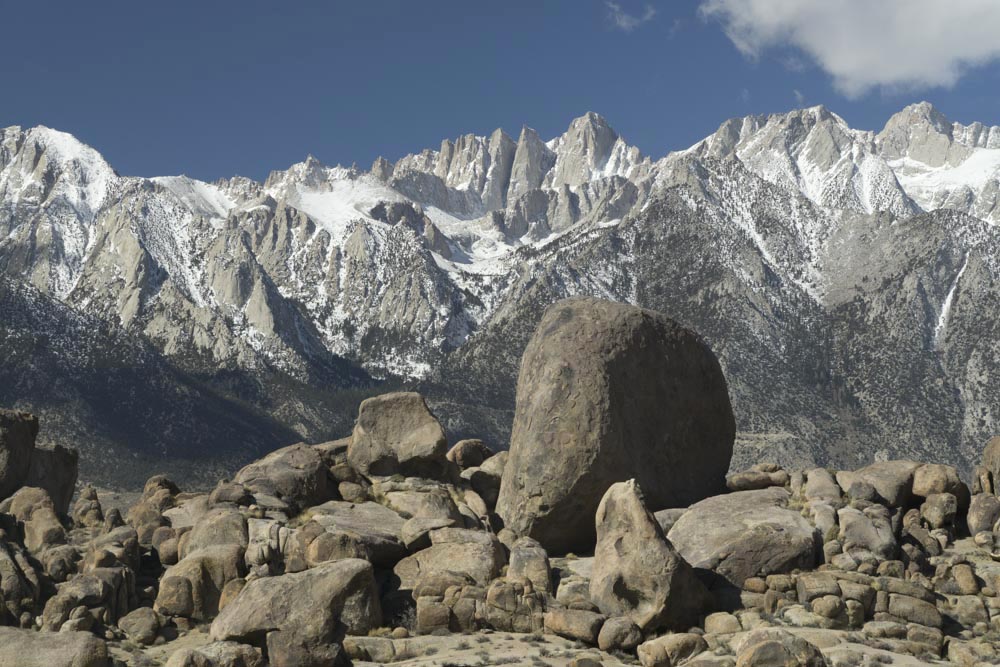
Spheroidal weathering in Cretaceous granitic rock, SE California. Mt. Whitney and the Sierra Nevada in background. (180314-91)
The “mafic minerals” are named so because they’re generally rich in iron and magnesium and poor in silica when compared to a lot of other common minerals –and they’re typically dark green to black in color, so “mafic rocks” like basaltic lavas also tend to be darker colored. The main mafic minerals are olivine, pyroxene, and amphibole. Olivine, as it turns out, is our planet’s most common mineral! It’s the main stuff of the mantle, which depending on where you are, lies some 10-40km below the surface.
Hikers on basalt flow on Mauna Loa Volcano in Hawaii; cinder cone (also basalt, but weathered red from oxidized iron) in background. Inset shows large olivine crystals in basalt surrounded by mostly pyroxene and calcium-rich plagioclase feldspar. (170917s-14) and 200517-4) Please click the link for a post on this amazing volcano!
The physical properties of these mafic minerals explain all sorts of things like why oceanic plates subduct beneath continental ones (being made of mafic minerals, they’re denser so they sink) to the shapes of volcanoes (mafic lavas, being less viscous than silicic ones, tend to form broad, low-relief shield volcanoes). For surface weathering and erosion, the mafic minerals tend to break down into clay more quickly than most other silicate minerals –which means that all else being equal, rocks with more mafic minerals will weather and erode faster than rocks with the other silicate minerals described here.
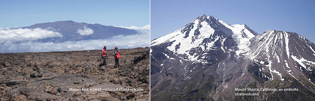
Mauna Kea Shield Volcano, Hawaii (left), made from basalt, which is more fluid (less viscous) than more silicic lavas like andesite, which make steeper cones such as Mt. Shasta in California. (170918s-83 and 140617-114)
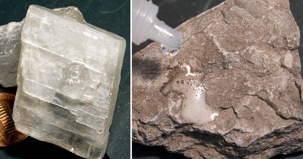
Finally, calcite, the sole non-silicate on this list, is hugely important because it’s what makes up the very common sedimentary rock limestone. Limestones occupy a separate class of sedimentary rock than sandstones: they’re “biogenic”, having formed through the precipitation of calcite through biological processes, as opposed to “clastic”, which are just broken particles. As a result, they’re important to understanding sedimentary rocks, and because of the biology connection, Earth history and evolution. For landscapes, limestones are also really important because the calcite will dissolve in slightly acidic water to form caves and sinkholes–there’s a whole class of landscape called “Karst”, which results from the dissolution of limestone.
The “fizz test”: calcite crystal (left) and limestone (right) both react with a weak solution of hydrochloric acid to give off carbon dioxide gas –because they’re both made of the same material (201122-11 and 201111-17)
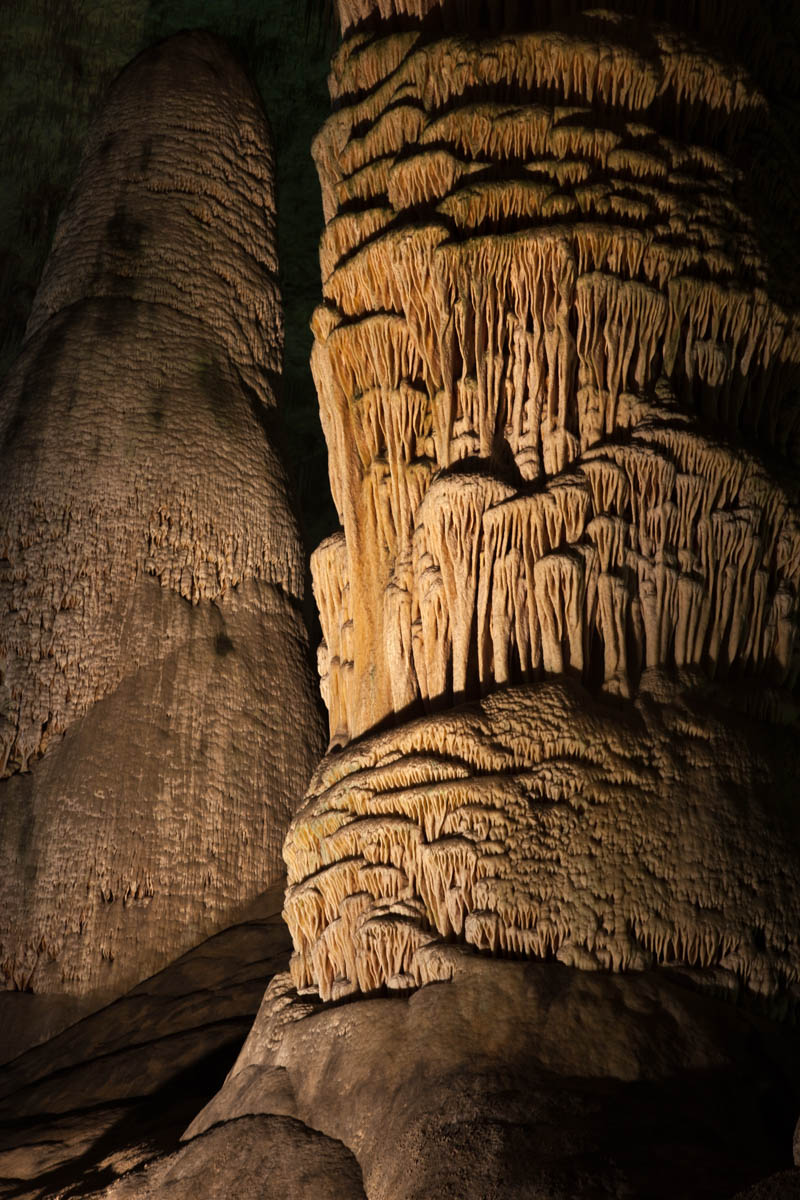
And re-precipitation of calcite within caves forms the beautiful speleothems we so love –stalactites, stalagmites, flowstone… the list goes on. That rock, called travertine, occupies a third class of sedimentary rock called “chemical sedimentary rocks”.
Stalagmite, Carlsbad Caverns NP, New Mexico. (100131-63)
Phew! My apologies to those mineralogy people who might read this and think, “but she missed that important idea! And that one too! And what about that mineral?” Maybe that’s the point though –this is just a start. There is so much these five minerals can teach us –and there are so many other wonderful minerals I didn’t even mention. So here’s to reading more info that somebody might’ve put into the comments section. Here also to all the geology majors out there who take upper level geology courses that delve into all the amazing detail and make connections that I wasn’t able to in this little space!
Olivine. I already know that I didn’t do olivine justice. (201119-20)
And if you want to download any of these photos for your own –just type in the photo id into the search function of my geology photo website.
Also, I posted a primer on rock types –if you’re interested, please have a look –and thanks for reading!
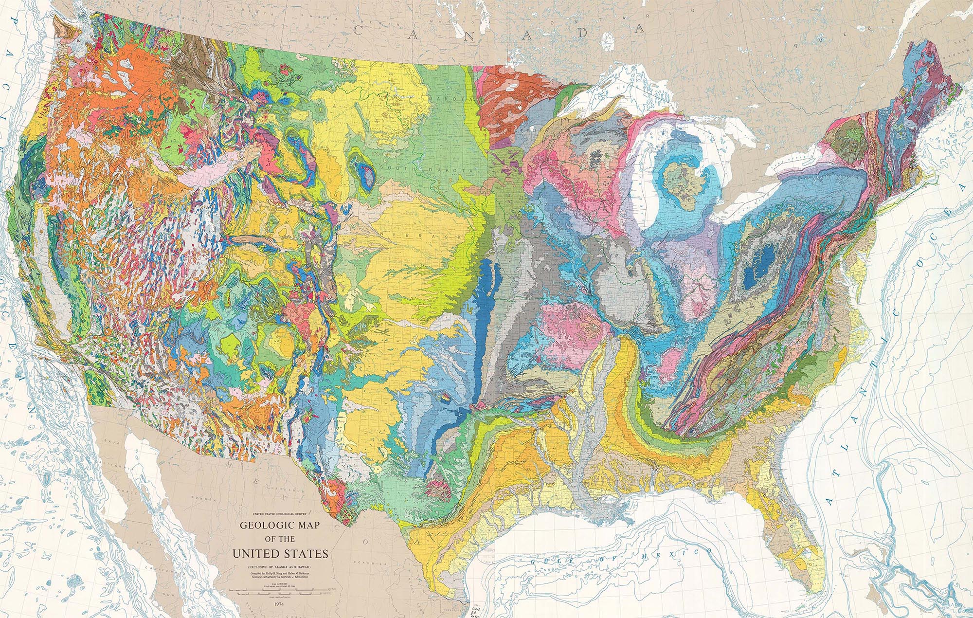
Published in 1974 by the US Geological Survey, the geologic map of the United States beautifully lays out our country’s geology. If you’re stuck at home these days –as most of us are—you can gaze at this masterpiece and go anywhere!
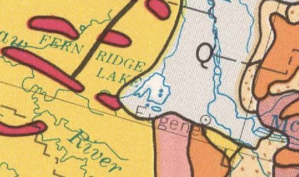
Southern Willamette Valley. Eugene’s in the center of the map
At their simplest, geologic maps read like road maps: they tell you what rock unit or recent deposit forms the ground at a given place. So right here where I am in Eugene, Oregon, I can see that I live on “Q” –which stretches north up the Willamette Valley. “Q” stands for Quaternary-age material (2.5 million years to present), which is typically alluvial material –or sediment deposited by rivers and streams. Just to the south of me lie a variety of older volcanic and sedimentary rocks. You can look them up in the map’s legend using their symbols. Here’s Rule #0: white areas, being mostly alluvium, mark low areas; colorful areas indicate bedrock, so are typically higher in elevation.
The beauty of this map is that you can see the whole country at once, and using just a few rules, can immediately glean the underlying structure of a region.For any of the maps, photos, and diagrams here, you can see a larger size if you click on the image.
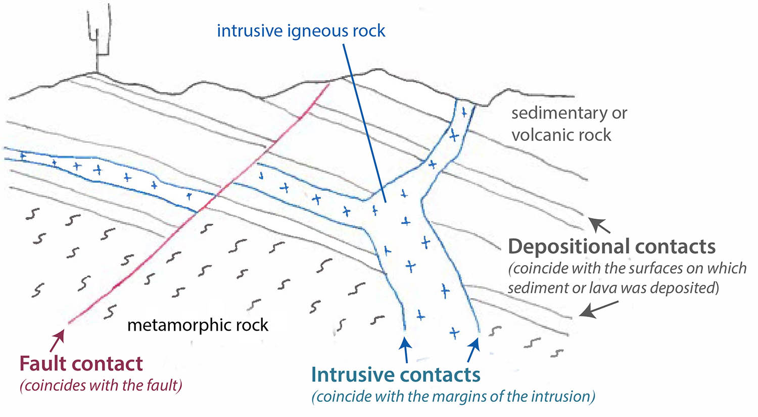
Rule 1: Rock bodies without internal contacts appear as color swatches (or “blobs”) as seen on the block diagram below. These rocks include intrusive igneous, undifferentiated metamorphic, and flat-lying sedimentary rock. (If you’re not sure what geologic contacts are, please see my recent post on the nature of geologic contacts.) Read more…
Geologic contacts are the surfaces where two different rocks touch each other –where they make contact. And there are only three types: depositional, intrusive, or fault. Contacts are one of the basic concerns in field geology and in creating geologic maps –and geologic maps are critical to comprehending the geology of a given area. For those of you out there who already know this stuff, I’ll do my best to spice it up with some nice photos. For those of you who don’t? This post is for you!
Depositional contacts are those where a sedimentary or volcanic rock was deposited on an older rock (of any type). Intrusive contacts are those where igneous rocks intrude older rock (of any type). Fault contacts are… faults! –surfaces where two rocks of any type have moved into their current positions next to each other along a fault.
In a cross-sectional sketch they may look like this:
And here are some photos. Click on the image to see it at full size.
So how do you tell them apart in the field? If the actual contact surface isn’t exposed –which is usually the case– you have to use some indirect observations. Here are some general rules that can help. Of course, each “rule” has exceptions, described later. Read more…
I always try for window seats when flying and I always try to shoot photos out the window –with varying results! So often, the window’s badly scratched, there are clouds, it’s hazy, the sun angle’s wrong –there are myriad factors that can make good photography almost impossible from a commercial jet. Last year though, I had a few amazing flights with clear skies and a great window seat –and I’ve now loaded nearly 100 images onto my website for free download. Here are 10 of my favorites, in no particular order. You can click on them to see them at a larger size. They’re even bigger on my website.
Mt. Shasta at sunset. Volumetrically, the biggest of the Cascade Volcanoes, Mt. Shasta last erupted between 2-300 years ago –and it’s spawned over 70 mudflows in the past 1000 years. From the photo, you can see how the volcano’s actually a combination of at least 3 volcanoes, including Shastina, which erupted about 11,000 years ago.
Aerial view of Mt. Shasta, a Cascades stratovolcano in northern California.
If you want to see more aerials of Mt. Shasta (shot during the day) –and from a small plane, go to the search page on my website and type in “Shasta”.
Meteor Crater, Arizona. Wow –I’ve ALWAYS wanted to get a photo of Meteor Crater from the air –and suddenly, on a flight from Phoenix to Denver, there it was!
Aerial view of Meteor Crater, Arizona
Meteor Crater, also called Barringer Crater, formed by the impact of a meteorite some 50,000 years ago. It measures 3900 feet in diameter and about 560 feet deep. The meteorite, called the Canyon Diablo Meteorite, was about 50 meters across.
Dakota Hogback and Colorado Front Range, near Morrison, Colorado. Same flight as Meteor Crater –and another photo I’d longed to take. It really isn’t the prettiest photo, BUT, it shows the Cretaceous Dakota Hogback angling from the bottom left of the photo northwards along the range and Red Rocks Amphitheater in the center –then everything behind Red Rocks, including the peaks of Rocky Mountain National Park in the background, consist of Proterozoic basement rock.
Aerial view of hogback of Cretaceous Dakota Formation and Colorado Front Range.
Distributary channels on delta, Texas Gulf Coast. I just thought this one was really pretty. Geologically, it shows how rivers divide into many distributary channels when they encounter the super low gradients of deltas. And whoever thought that flying into Houston could be so exciting!
Distributary channels on delta, Texas Gulf Coast
Meander bends on the Mississippi River. My mother lives in Florida, so I always fly over the Mississippi River when I go visit –but I was never able to take a decent photo until my return trip last October, when the air was clear, and our flight path passed just north of New Orleans. Those sweeping arms of each meander are about 5 miles long!
Meander bends on the Mississippi River floodplain, Louisiana
Salt Evaporators, San Francisco Bay. Flying into San Francisco is always great because you get to see the incredible evaporation ponds near the south end of the bay. I always love the colors, caused by differing concentrations of algae –which respond to differences in salinity. And for some reason, salt deposits always spark my imagination. Salt covers the floor of Death Valley, a place where I do most of my research, and Permian salt deposits play a big role in the geology of much of southeastern Utah, another place I know and love.
Salt evaporators, San Francisco Bay, California
Bonneville Salt Flats and Newfoundland Mountains, Utah. And then there are the Bonneville Salt Flats! They’re so vast –how I’d love the time to explore them. They formed by evaporation of Pleistocene Lake Bonneville, the ancestor of today’s Great Salt Lake. When the climate was wetter during the Ice Age, Lake Bonneville was practically an inland sea –and this photo shows just a small part of it.
Aerial view of Bonneville Salt Flats and Newfoundland Mountains
Stranded meander loop on the Colorado River. I like this photo because it speaks to the evolution of this stretch of the Colorado River. Just left of center, you can see an old meander loop –and it’s at a much higher elevation than today’s channel. At one time, the Colorado River flowed around that loop, but after breaching the divide and stranding it as an oxbow, it proceeded to cut its channel deeper and left the oxbow at a higher elevation.
Stranded meander loop (oxbow) on the Colorado River, eastern Utah
San Andreas fault zone and San Francisco. See those skinny lakes running diagonally through the center of the photo? They’re the Upper and Lower Crystal Springs Reservoirs –and they’re right on the San Andreas Fault. And you can see just how close San Francisco is to the fault. As the boundary between the Pacific and North American Plates, its total displacement is about 200 miles. See this previous post for more photos of the San Andreas fault.
San Andreas fault zone and San Francisco
And my favorite: Aerial view of the Green River flowing through the Split Mountain Anticline –at Dinosaur National Monument, Utah-Colorado. Another photo I’ve so longed to shoot –but didn’t have the opportunity until last year.
The Green River cuts right across the anticline rather than flowing around it. It’s either an antecedent river, which cut down across the fold as it grew –or a superposed one, having established its channel in younger, more homogeneous rock before cutting down into the harder, folded rock. You can also see how the anticline plunges westward (left) because that’s the direction of its “nose” –or the direction the fold limbs come together. The quarry, for Dinosaur National Monument, which you can visit and see dinosaur bones in the original Jurassic bedrock, is in the hills at the far lower left corner of the photo.
Split Mountain anticline and Green River, Utah-Colorado
So these are my ten favorites from 2019. Thanks for looking! There are 88 more on my website, at slightly higher resolutions and for free download. They include aerials of the Sierra Nevada and Owens Valley, the Colorado Rockies, including the San Juan Volcanic Field, incised rivers on the Colorado Plateau, and even the Book Cliffs in eastern Colorado. Just go to my geology photo website, and in the search function type “aerial, 2019” –and 98 photos will pop up. Boom!
Smith Rock, the Crooked River, and modern Cascade volcanoes from Misery Ridge.
The view from outside the small visitor center at Smith Rock State Park offers a landscape of contrasts. The parking lot, and nearby camping and picnic areas, are flat, underlain by the edge of a basaltic lava flow that drops off in a series of steps to a narrow canyon, some 120 feet (37 m) below. The Crooked River, which rises about 100 miles (162 km) away in the High Lava Plains, fills much of the canyon bottom. Across the canyon, tan cliffs and spires of tuff, another volcanic rock, soar overhead. Smith Rock itself forms a peninsula of this rock, enclosed by a hairpin bend of the Crooked River. The tuff erupted 29.5 million years ago in the largest volcanic eruption to occur entirely within Oregon. Read more…