geologictimepics

Geology and Geologic Time through Photographs

Archive for the tag “rocks”

Five Awesome Minerals –for rocks and landscapes

All told, we humans have discovered more than 5000 mineral types. I challenged myself to list the five most important minerals when it comes to the formation of rocks and their subsequent weathering and erosion into landscape.

Rock, which makes up our planet, consists of different minerals. This granite is made of, Q=quartz, O=orthoclase feldspar, P=plagioclase feldspar, B=biotite mica (IP18-1012ce)

It’s an impossible task –and subjective, of course –and I fudged a bit by grouping some minerals together. But here they are: the silicate minerals quartz, mica, feldspar, and mafic minerals, and the carbonate mineral, calcite. I invite you to take me to task in the comments section. Even so, these five minerals are easy to identify and are critical to any discussion about rocks –which makes them important to understanding weathering and erosion. And, I’m adding them to my already packed curriculum for my introductory class on surface processes next term, so five seems to be a good upper limit on the numbers.

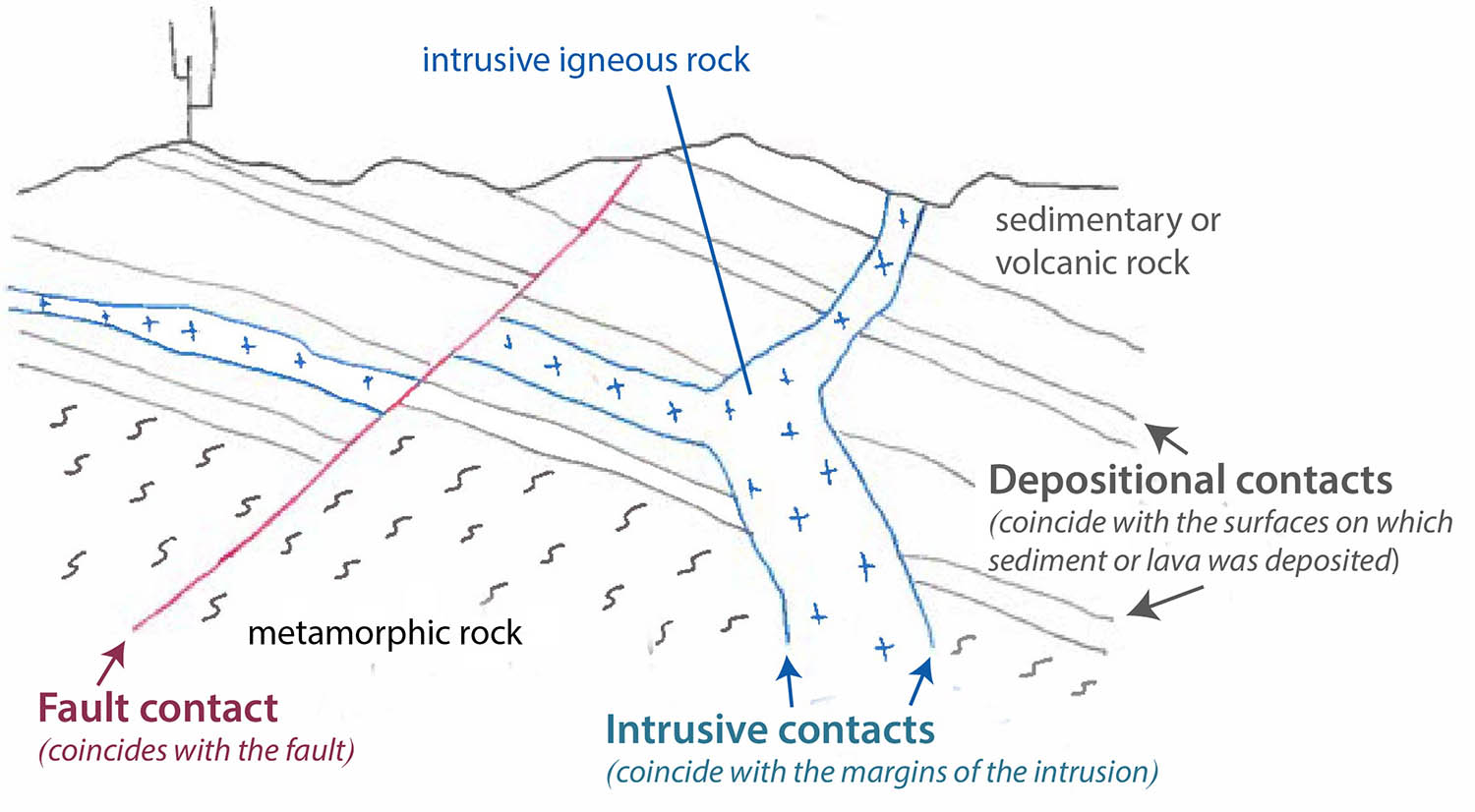
Oh! Click on any image to see it enlarged on a separate page.

The five awesomest minerals

Weathering, by the way, is the in-place physical and/or chemical breakdown of rock; erosion is its removal –so they go hand-in-hand. A lot goes into how susceptible a rock is to these processes—not just the mineral content—and when it comes to chemical breakdown, the main factors always involve water. If a rock is accessible to water, it will break down more quickly; if it’s not accessible to water, it will be more resistant.

Fractures in granite collect water and host vegetation, focusing weathering along the fracture. Acadia National Park, Maine. (100608-59)

Because some rocks will weather and erode more quickly than others, landscapes form with cliffs and valleys and steep slopes, gentle slopes –all sorts of variation you can imagine—depending in part on the bedrock. We call the phenomenon “differential erosion”. You can find more detail on the processes in one of my earlier posts, called “Shaping of Landscape“.

Differential weathering and erosion: Mexican Hat, Utah (9OtR-049)

Ok… the minerals:

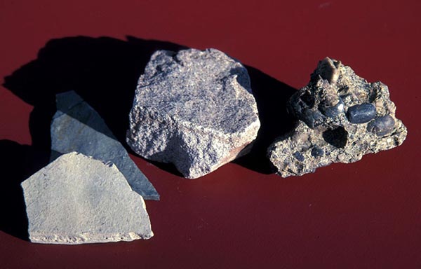
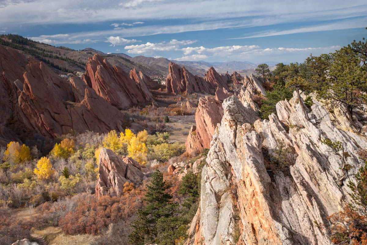
Quartz  –most people have come to know quartz because of its pretty crystals –especially the purple variety called amethyst—but they might not realize that it’s a hugely important component of many igneous, metamorphic, and sedimentary rocks, and it forms the cement of many sedimentary rocks.  When it comes to weathering, quartz is practically inert chemically, so a strongly quartz-cemented sandstone will be more resistant to weathering and erosion than most other sedimentary rocks. The sandstone will stand out in relief, likely as cliffs or even overhangs. By contrast, weakly cemented, often finer-grained rocks tend to form slopes or even valleys.

Differential erosion along the Front Range of Colorado: resistant, inclined sandstone beds form ridges while intervening shale forms a valley. (131025-52)

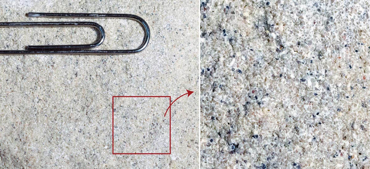
If you look closely at a sandstone like the one below, chance are you’ll see mostly quartz grains. Quartz grains might break up into little pieces as they’re being transported by rivers, for example, but they won’t turn into clay like most other minerals. The result? Sediment gets increasingly rich in quartz the farther it’s transported from its source –and so if it travels a great distance, quartz is just about the only thing left!

Close-up views of quartz sandstone and cement. Photo on right is enlarged approx 3x. (click on it to see it even larger) Nearly all those little sand-sized particles are quartz! (201120-10i)

And if you’re one of those people who really love this mineral, check out this post by Roseanne Chambers, which is all about quartz!

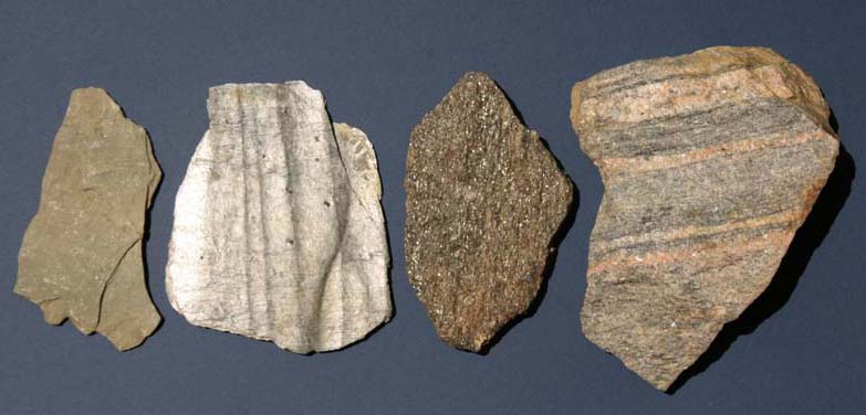
Micas are those shiny sheet-like minerals we see catching the light in a whole host of rocks. The best known micas are muscovite (white mica) and biotite (black mica). In metamorphism, they grow larger with increases in temperature, providing a handy way to distinguish between slate, phyllite, and schist — a nice thing to know in a geology class. The diagram below illustrates the process.

With increasing temperature, the clay within shale will recrystallize to microscopic mica to make slate a hard, metamorphic rock with a dull luster. Even hotter and the micas grow larger to produce phyllite, which has a reflective sheen, and then become easily visible in schist. Hotter still and coarse minerals segregate into layers to make gneiss. (201119-12e)

When it comes to weathering and erosion, those little mica sheets allow infiltration of water. Metamorphic rocks overall are pretty resistant because of their crystallinity –but slates or schist, for example, degrade much more quickly than gneisses because of their prevalence of mica minerals, which together create a fine-scale layering in the rock. Gneisses are coarse-grained, and their layering tends to be thicker and less permeable.

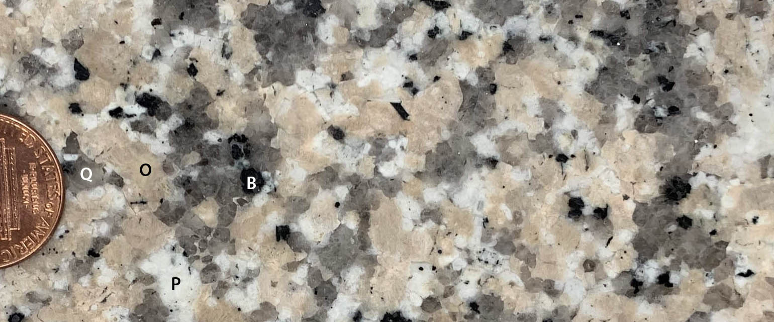
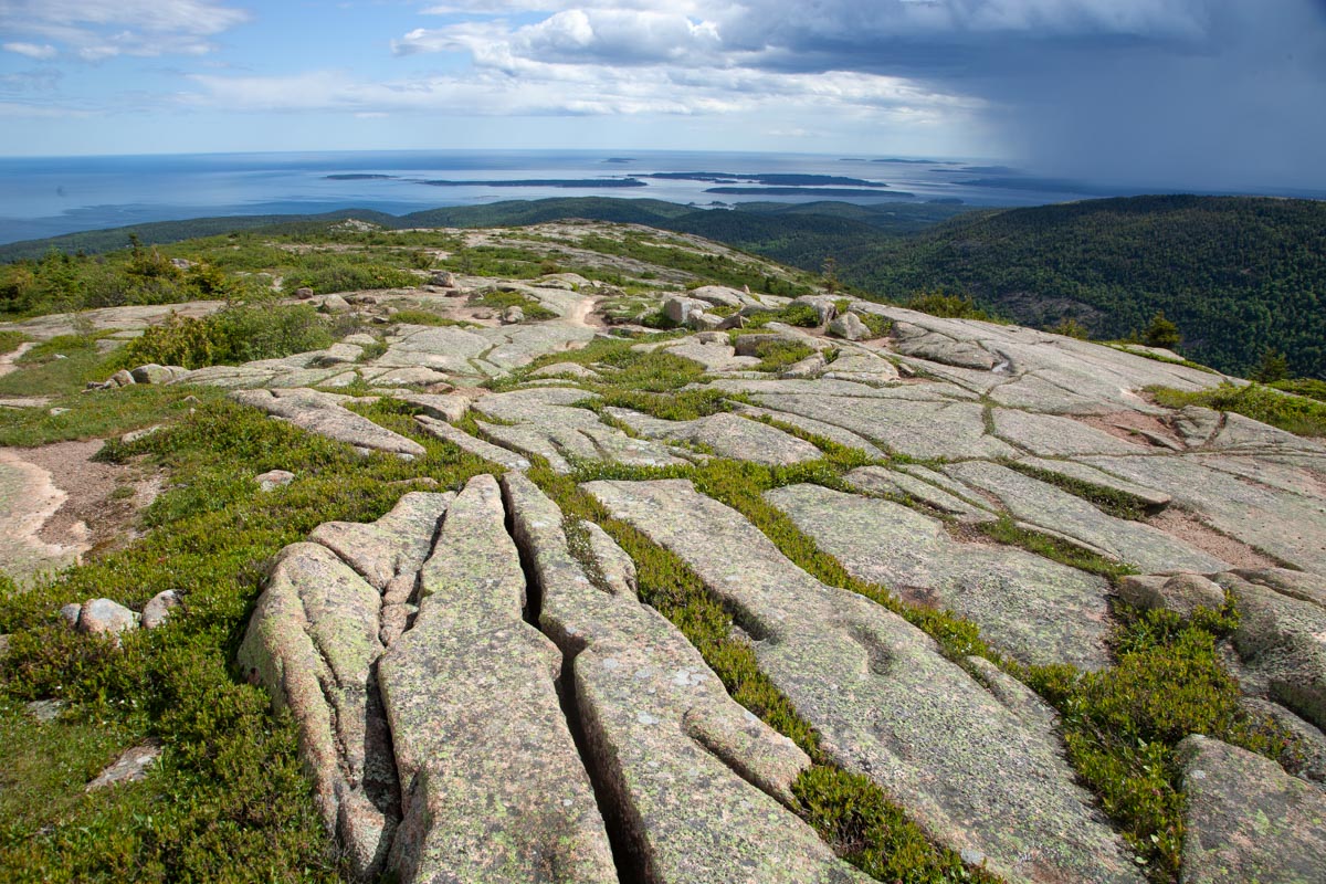
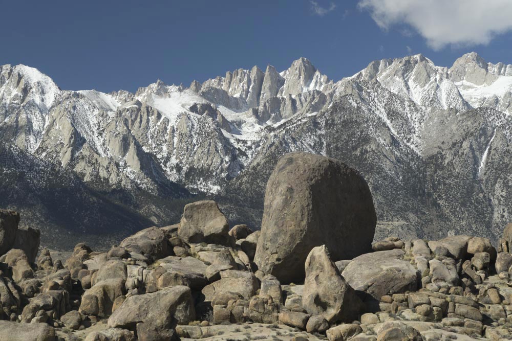
Collectively, feldspars are the most common minerals of the Earth’s crust –and there are numerous varieties, the most common being orthoclase and plagioclase, which often occur together. For the purposes of landscapes, I grouped them together as one: they’re all kind of chunky looking and are generally light-colored. Feldspars are the main components of igneous rocks, making up 60-70% (or even more) of most granitic rocks, which tend to form distinctive landscapes marked by cliffs and large rounded boulders.

Spheroidal weathering in Cretaceous granitic rock, SE California. Mt. Whitney and the Sierra Nevada in background. (180314-91)

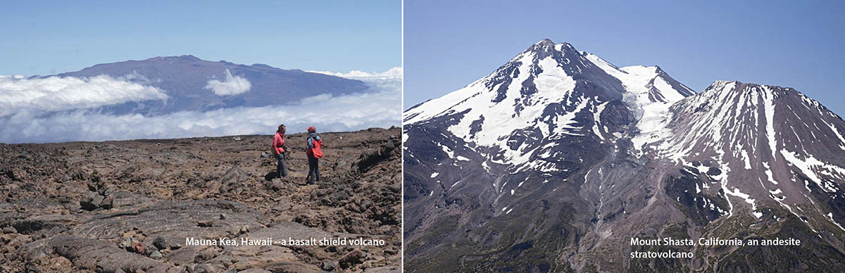
The “mafic minerals” are named so because they’re generally rich in iron and magnesium and poor in silica when compared to a lot of other common minerals –and they’re typically dark green to black in color, so “mafic rocks” like basaltic lavas also tend to be darker colored. The main mafic minerals are olivine, pyroxene, and amphibole. Olivine, as it turns out, is our planet’s most common mineral! It’s the main stuff of the mantle, which depending on where you are, lies some 10-40km below the surface.

Hikers on basalt flow on Mauna Loa Volcano in Hawaii; cinder cone (also basalt, but weathered red from oxidized iron) in background. Inset shows large olivine crystals in basalt surrounded by mostly pyroxene and calcium-rich plagioclase feldspar. (170917s-14) and 200517-4) Please click the link for a post on this amazing volcano!

The physical properties of these mafic minerals explain all sorts of things like why oceanic plates subduct beneath continental ones (being made of mafic minerals, they’re denser so they sink) to the shapes of volcanoes (mafic lavas, being less viscous than silicic ones, tend to form broad, low-relief shield volcanoes). For surface weathering and erosion, the mafic minerals tend to break down into clay more quickly than most other silicate minerals –which means that all else being equal, rocks with more mafic minerals will weather and erode faster than rocks with the other silicate minerals described here.

Mauna Kea Shield Volcano, Hawaii (left), made from basalt, which is more fluid (less viscous) than more silicic lavas like andesite, which make steeper cones such as Mt. Shasta in California. (170918s-83 and 140617-114)

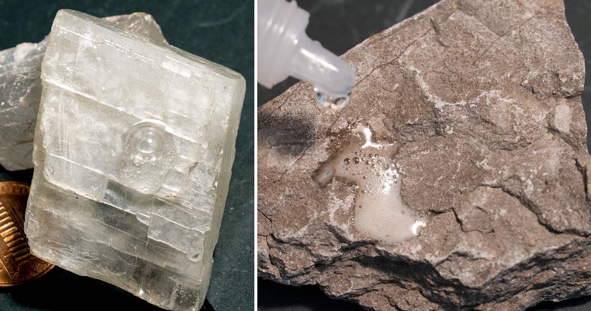
Finally, calcite, the sole non-silicate on this list, is hugely important because it’s what makes up the very common sedimentary rock limestone. Limestones occupy a separate class of sedimentary rock than sandstones: they’re “biogenic”, having formed through the precipitation of calcite through biological processes, as opposed to “clastic”, which are just broken particles. As a result, they’re important to understanding sedimentary rocks, and because of the biology connection, Earth history and evolution. For landscapes, limestones are also really important because the calcite will dissolve in slightly acidic water to form caves and sinkholes–there’s a whole class of landscape called “Karst”, which results from the dissolution of limestone.

The “fizz test”: calcite crystal (left) and limestone (right) both react with a weak solution of hydrochloric acid to give off carbon dioxide gas –because they’re both made of the same material (201122-11 and 201111-17)

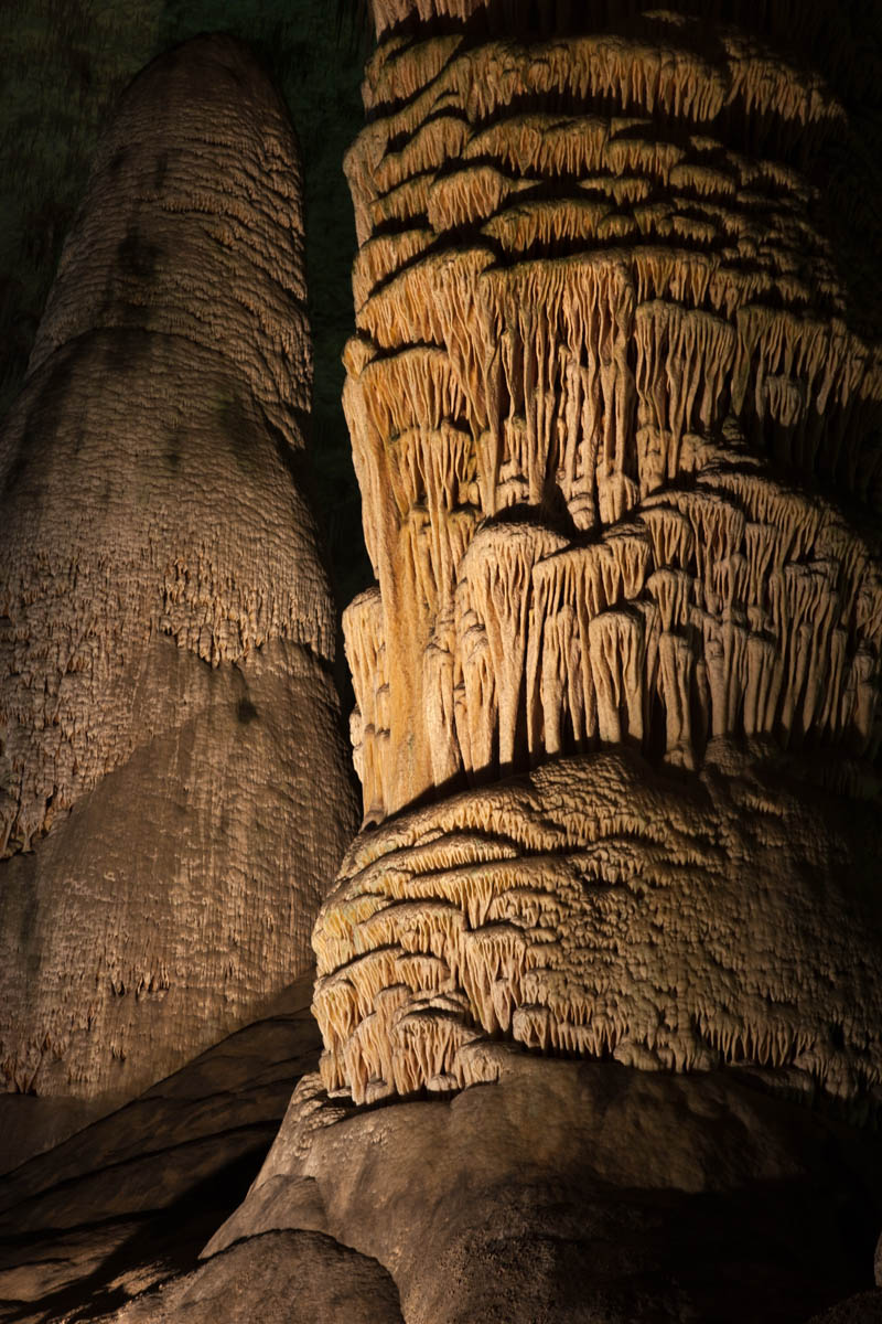
And re-precipitation of calcite within caves forms the beautiful speleothems we so love –stalactites, stalagmites, flowstone… the list goes on. That rock, called travertine, occupies a third class of sedimentary rock called “chemical sedimentary rocks”.

Stalagmite, Carlsbad Caverns NP, New Mexico. (100131-63)

Phew! My apologies to those mineralogy people who might read this and think, “but she missed that important idea! And that one too! And what about that mineral?” Maybe that’s the point though –this is just a start. There is so much these five minerals can teach us –and there are so many other wonderful minerals I didn’t even mention. So here’s to reading more info that somebody might’ve put into the comments section. Here also to all the geology majors out there who take upper level geology courses that delve into all the amazing detail and make connections that I wasn’t able to in this little space!

Olivine. I already know that I didn’t do olivine justice. (201119-20)

And if you want to download any of these photos for your own –just type in the photo id into the search function of my geology photo website.

Also, I posted a primer on rock types –if you’re interested, please have a look –and thanks for reading!

Where rocks touch: geologic contacts

Geologic contacts are the surfaces where two different rocks touch each other –where they make contact. And there are only three types: depositional, intrusive, or fault. Contacts are one of the basic concerns in field geology and in creating geologic maps –and geologic maps are critical to comprehending the geology of a given area. For those of you out there who already know this stuff, I’ll do my best to spice it up with some nice photos. For those of you who don’t? This post is for you!

Depositional contacts are those where a sedimentary or volcanic rock was deposited on an older rock (of any type). Intrusive contacts are those where igneous rocks intrude older rock (of any type). Fault contacts are… faults! –surfaces where two rocks of any type have moved into their current positions next to each other along a fault.

In a cross-sectional sketch they may look like this:x-sxnlr

And here are some photos. Click on the image to see it at full size.Depositional contact and windows,  Jurassic Entrada Fm (red) ove

So how do you tell them apart in the field? If the actual contact surface isn’t exposed –which is usually the case– you have to use some indirect observations. Here are some general rules that can help. Of course, each “rule” has exceptions, described later. Read more…

Sampling New Zealand’s (Amazing) Geology

New Zealand’s landscape can make just about anybody appreciate geology. Its glaciated peaks, its coastline –that ranges from ragged cliffs to sandy beaches to glacial fjords– its active volcanoes… they all work together to shout “Earth Science!” With that in mind, here’s some basics of New Zealand’s amazing geology, followed by some geological highlights of my trip of January and early February, 2018.

NZ map--all

Map of New Zealand, showing accreted terranes in colors and cover assemblage in gray. (Compiled mostly from Graham, 2015)

North and South Island Bedrock  The different colors on this map show New Zealand’s basement rock, named so because it forms the lowest known bedrock foundation of any given area. The basement tells stories of New Zealand’s deep past, from about 500-100 million years ago. Individual colors signify different terranes, accreted (added) one-by-one through plate motions to the edge of what was then the supercontinent Gondwana. They mostly consist of sedimentary and metamorphosed sedimentary rock, although the narrow belt of purple-colored Dun Mountain Ophiolite formed as oceanic lithosphere, and the red-colored areas consist of granitic igneous rock, some of which has been metamorphosed to gneiss.

Gray indicates the younger cover rock, formed after accretion of the terranes. Consisting of a wide range of sedimentary and volcanic rocks, as well as recently deposited sediment, it’s just as interesting and variable as the terranes. Because it includes volcanoes, it’s largely the cover that gives the North Island its distinctive flair. By contrast, the South Island consists largely of uplifted basement rock, much of which has been –and still is—glaciated. All those long deep lakes, such as Lakes Wanaka and Tekapo, were carved by glaciers and are now floored with their deposits of till.

Andesite stratovolcano, New Zealand

Mt. Ngauruhoe, a 7000 year-old andesite stratocone near Ruapehu on the North Island

Those differences exist largely because the North and South Islands occupy different plate tectonic settings. The North Island sits over a subduction zone, so it hosts an active Read more…

Cove Palisades, Oregon: a tidy short story in the vastness of time

If I were a water skier, I’d go to Lake Billy Chinook at Cove Palisades where I could ski and see amazing geology at the same time. On the other hand, I’d probably keep crashing because the geology is so dramatic! Maybe a canoe would be better.

Lake Billy Chinook, Oregon

View across the Crooked River Arm of Lake Billy Chinook to some of the 1.2 million year old canyon-filling basalt (right) and Deschutes Fm (left). The cliff on the far left of the photo is also part of the 1.2 million year basalt.

The lake itself fills canyons of the Crooked, Deschutes and Metolius Rivers. It backs up behind Round Butte Dam, which blocks the river channel just down from where the rivers merge. The rocks here tell a story of earlier river canyons that occupied the same places as today’s Crooked and Deschutes Rivers. These older canyons were filled by basaltic lava flows that now line some of the walls of today’s canyons.

CovePalisades2
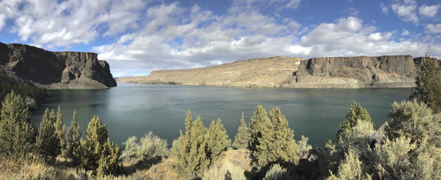
From the geologic map, modified from Bishop and Smith, 1990, you can see how the brown-colored canyon-filling basalt, (called the “Intracanyon Basalt”) forms narrow outcrops within today’s Crooked and Deschutes canyon areas. It erupted about 1.2 million years ago and flowed from a vent about 60 miles to the south. You can also see that most of the bedrock (in shades of green) consists of the Deschutes Formation, and that there are a lot of landslides along the canyon sides.

The cross-section at the bottom of the map shows the view along a west-to-east line. Multiple flows of the intracanyon basalt filled the canyon 1.2 million years ago –and since then the river has re-established its channel pretty much in the old canyon. While the map and cross-section views suggest the flows moved down narrow valleys or canyons, you can actually see the canyon edges, several of which are visible right from the road.

Read more…

Rocks! –a brief illustrated primer

click on any image to see a larger version

Seems like most people I know like rocks. They bring home unusual rocks from vacations; they admire beautiful facing stones on buildings; they frequently ask “What is this rock”? Considering that the type of rock you’re looking at reflects the processes that caused it to form, some basic rock identification skills can go a long way to understanding our planet!

ip4086

Rock (left, igneous-granite) and minerals (right, quartz and kyanite). Notice that the granite is made of a variety of minerals.

Of course there are thousands of different rock types —But! they ALL fit into one of three categories: igneous, sedimentary, or metamorphic. Here’s a brief, illustrated summary of each.

Igneous rocks are those that form by cooling and crystallization from a molten state. Consequently, they consist of crystals of various minerals that form an interlocking mosaic like the rock in the photo to the right. Igneous rocks are further classified as “intrusive” or “extrusive”, depending if they form beneath Earth’s surface (intrusive) or on Earth’s surface (extrusive). Extrusive rocks are more commonly called volcanic rocks. Generally speaking, intrusive rocks are coarsely crystalline whereas volcanic ones are finely crystalline. Check out this gallery of igneous rock photos.

Sedimentary rocks are made of particles (“sediment”) of pre-existing rock that are deposited as layers on Earth’s surface and then become cemented together. Individual layers of sedimentary rock are called “beds”. Bedding is best observed from a distance; most individual sedimentary rocks come from within a bed and so may appear homogeneous. Check out this gallery of sedimentary rock photos.

Metamorphic rocks are pre-existing rocks that change (“metamorphose”) because they are subject to high temperatures and/or pressures. This change involves the growth of new crystals in the rock. Because this growth typically occurs under conditions of high pressure as well as temperature, the new minerals tend to grow in a preferred orientation, leading to a fine-scale layering in the rock. This layering is called foliation. Unlike bedding in sedimentary rock, foliation tends to be irregular and marked by differently colored zones of different minerals. Check out this gallery of metamorphic rock photos.

ip4082

Sedimentary (sandstone, L), Igneous (granite, Ctr), and Metamorphic (gneiss, R) specimens

Key

simplified key to recognizing main rock types

Telling Igneous, Sedimentary, and Metamorphic rocks apart is usually pretty easy. First, decide if the rock consists of crystals or rounded grains. If it consists of crystals, then it is igneous or metamorphic; if it consists of grains, then it is sedimentary. If the crystals are arranged into layers or bands, the rock is metamorphic; if they are randomly arranged, then it is igneous. Igneous rocks with large crystals generally indicate slow cooling within the earth (intrusive). Conversely, igneous rocks with small crystals generally indicate rapid cooling on Earth’s surface (volcanic).

Igneous Rock –more details

Intrusive and volcanic rocks are further classified based on their chemistry and texture according to the chart below. This is one place where mineral identification becomes very important because minerals reflect the rock’s chemistry. Importantly, rocks with high silica content, such as rhyolite and granite, typically have fairly low iron contents, and so tend to have minerals that are light in color, such as K-feldspar, sodium-rich plagioclase, and quartz. Conversely, rocks with low silica content, such as basalt and gabbro, typically have high iron contents, and so have minerals that tend to be dark in color.

 Intro-1. Ig rx-CS4
Principal igneous rock types. Their classification depends on texture and composition. Fine-grained rocks are extrusive (upper row), whereas coarse-grained rocks are intrusive (lower row). Silica content then determines the specific rock name: gabbro and basalt <50-57%, SiO2; diorite and andesite, 57-67%; granite and rhyolite, 67+%.   Notice that rocks tend to be darker, denser, and more iron rich towards the lower silica end of the spectrum.

More on Volcanic Rock
Being igneous, volcanic rocks are made of crystals –but they’re so fine grained, you often can’t see that without a microscope. Thankfully, many volcanic rocks contain phenocrysts, larger crystals surrounded by the finer grained matrix. If you look closely at the photos of basalt and andesite above, you can see phenocrysts of plagioclase feldspar as the small white things.

Below are more photos, showing a more enlarged view of a rock with phenocrysts. Note how fine grained the surrounding matrix is –you can’t really see anything at all. If you look at the microscopic view though you can see that the whole rock is crystalline, even the super-fine matrix. The point here is that, unless the rock contains glass (see next section), the whole rock is crystalline!

phenos

Porphyritic volcanic rock in hand sample (left) and microscopically (right). Note how microscopic view

Volcanic: Glass
One of the more ubiquitous volcanic products, volcanic glass is just that –glass–so it lacks a crystal structure. Glass can form when the lava is so dry as to inhibit crystal growth, as in obsidian, or when lava cools so quickly as to prevent crystal growth, such as with volcanic ash and pumice.

The photos below show pumice, which is frothy volcanic glass. It gets that texture because it forms during violent eruptions –explosively expanding gases in the lava shatter the fast-cooling material so that the rock consists of air bubbles (called vesicles) separated by glassy sidewalls.

171026-7pumice

Pumice: frothy volcanic glass from instantaneous cooling. Left-hand image shows close-up view of glass threads. Paper clip for scale.

Volcanic: Pyroclastic Material and Rocks
Pyroclastic materials (also called “tephra”) form during explosive eruptions and so consist of rock fragments and glass ejected violently from the volcano. We classify it according to its size: large fragments are called blocks or bombs; small particles, between about 2mm – 64mm, are called “lapilli”; tiny particles, smaller than 2mm, are called “ash“.  Pumice is also pyroclastic, but it’s considered its own rock type –and it can be of any size. Pyroclastic falls can result from any explosive eruption in which pyroclastic materials fall out from the atmosphere; pyroclastic flows are those that flow out over the ground surface.

120619-5clrlabels

Most tuff contains fragments of pumice in a matrix of ash

Now the rocks. The most common pyroclastic rock is undoubtedly “tuff”, which is composed largely of ash and pumice fragments, erupted mostly during rhyolitic eruptions. Air fall tuff forms from ash that accumulates in layers as it settles from the atmosphere; Ash flow tuff forms from bodies of ash that flow rapidly along the ground, typically incinerating everything in their paths. Because the material flows, it typically does not form layers. Many ash flow tuffs are welded (called “welded tuff”) because of the high temperatures. These highly welded tuffs are sometimes called “ignimbrites”. To identify tuff, look for pieces of pumice floating around in the ashy matrix.

Below’s a view of the Bandelier Tuff in northern New Mexico. It’s a series of ash flow tuffs formed during huge eruptions 1.6 and 1.25 million years ago in the Jemez Mountains. These eruptions formed the Valles-Toledo Caldera (generally just called the “Valles Caldera”). You can get an idea as to the size of the eruptions based on the size of the flows: they’re thick!

Bandelier Tuff, Los Alamos, New Mexico

Cliffs of Bandelier Tuff, erupted from Valles Caldera, New Mexico.

New Zealand’s Taupo Volcanic Zone hosts the most frequent recent rhyolitic eruptions than anywhere else in the world, all active in the last 2 million years. The most recent big eruptions, 26,500 and 1800 years ago, were centered on Lake Taupo, near the middle of the North Island. Below is a map showing the distribution of airfall and ignimbrite (welded ash flow) deposits formed during the eruption at AD 186, just over 1800 years ago. The estimated volume of all eruptive products during this eruption exceeds 105 km3 (Wilson, and Walker, 1985). By comparison, the older “Oruanui” eruption, 26,500 years ago? It likely erupted more than 1000 km3! (Wilson, 2001).

Taupo deposits

Taupo vent (red triangle) and distribution of airfall and ashflow deposits from AD186 eruption.  Inset shows Taupo Volcanic Zone on New Zealand’s North Island. From Wilson and Walker, 1985.

references for Taupo eruptions:
Wilson, C.J.N., and Walker, G.P.L., 1985, The Taupo eruption, New Zealand i. General Aspects, Philosophical Transactions of the Royal Society of London, v. 314, p. 199-228.

Wilson, C.J.N., 2001, The 26.5 Oruanui eruption, New Zealand: an introduction and overview, Journal of Volcanology and Geothermal Research, v. 112, p. 133-174).

Sedimentary Rock –More details

Sedimentary rock may be clastic, biogenic, or chemical, depending on how the particles formed. Clastic sedimentary rocks contain actual pieces of the pre-existing rock that have been transported from the original source. During this transportation, the particle breaks into smaller grains and typically becomes rounded. Clastic sedimentary rocks are further classified according to grain size: shale contains clay-sized grains; siltstone contains silt-sized grains; sandstone contains sand-sized grains; conglomerate contains grains that are pebble to boulder-sized.

Sed-54

Clastic sedimentary rocks: shale (left), sandstone (center), and conglomerate (right).

Biogenic sedimentary rocks are those that form through biological activity. By far the most common example is limestone, which forms by the production of calcium carbonate by algae and invertebrate animals for shells.   Other examples include dolomite, which forms by the same process as limestone, and chert, which forms by the accumulation of silica-producing organisms on the sea floor.

Chemical sedimentary rocks form by non-biologically induced precipation of minerals. Examples include sinter and travertine, which consist of silica and calcium carbonate respectively, precipitated from hot water at thermal springs. Another important example is bedded salt, which forms today by evaporation in closed desert basins.

30-7624

Tilted sedimentary rocks –started out horizontally.

You can’t see the bedding in the rock samples shown above, but if you were to stand back from an outcrop of sedimentary rocks, you probably could see the bedding. That’s because most individual samples don’t go across bedding but instead come from individual beds.


Metamorphic Rock –more details

Most metamorphic rocks are classified according to their grain size and the resulting nature of their foliation. Slates are the finest grained metamorphic rock, followed by phyllite, schist, and gneiss, being the coarsest grained. Gneiss is especially distinctive because most of its crystals are readily visible and its foliation is marked by bands of different minerals. In general, crystal size corresponds to the metamorphic grade, or intensity, with the most coarsely crystalline rocks being of the highest grades.

Met-01c

Metamorphic rocks. From left to right: slate, phyllite, schist, gneiss. Note that each rock has layering (foliation) that is caused by a parallel arrangement of platy minerals within the rock.

And then there are metamorphic rocks that form just because of high temperatures, typically because they were heated by the intrusion of a nearby igneous body. This type of metamorphism, called “contact metamorphism” is a common origin for non-foliated marbles and quartzites. Marble forms by contact metamorphism of limestone and dolomite; quartzite forms by contact metamorphism of sandstone.

The photo on the below shows the igneous rock diorite intruding the sedimentary Helena Dolomite in Glacier National Park, Montana. You can see how contact metamorphism has turned the dolomite next to the intrusion into a white marble. Ooooh!

ContactMetIg-25

Intrusive “sill” of diorite and the resulting contact metamorphism of adjacent gray dolomite to white marble in Glacier National Park, MT.


For more, higher resolution photos of each feature or rock type, try doing a geology keyword search for any of the rock types or features described here. Some useful keywords are “igneous, intrusive, volcanic, metamorphic, sedimentary, phenocryst, tuff, pumice, or volcanic glass” –or any others you can think of. Enjoy!


Mauna Loa Volcano, Hawai’i –Earth’s largest active volcano

To get an idea of the immensity of Mauna Loa Volcano, take a look at the photo below. That rounded shape continues from its summit area at 13,678 feet above sea level to about 18,000 feet below sea level –and then another 25,000 feet or so below that because the mountain has sunk into the oceanic crust. It’s unquestionably the world’s largest active volcano.

Mauna Loa Shield Volcano

Profile of Mauna Loa Shield Volcano from… Mauna Loa Shield Volcano! (Geologypics: (170919s-15))

Briefly, Mauna Loa’s made of basalt. Basaltic lava flows, being comparatively low in silica, have low viscosities and so cannot maintain steep slopes, resulting in broad, relatively low gradient volcanoes called shields. With just a little imagination, you can see how Mauna Loa’s shape resembles that back side of some shield one of King Arthur’s Knights might carry into battle.

Read more…

Geologypics.com– A new (and free) resource for geological photographs

What better way to kick off my new website than to write about it on my blog? To see it, you just need to click on the word “home” in the space above. Or you can click the link: geologypics.com.

Here’s part of the front page:
home3

As it says, the site offers free downloads for instructors –and for anybody who’s craving a good geology photograph. It’s my way of contributing to geology education –showing off some of our landscape’s amazing stories and providing resources for other folks who want to do the same.

I think the best part of the whole site is that red button in the middle of the home page. It says “Image Search by Keyword”.

Right now, there are more than 2200 images you can search for — all of which are downloadable at resolutions that generally work for powerpoint. If you search for “sea stack” for example, you’ll get 38 hits –and the page will look like this:

Sea Stack search

First page of sea stacks when you search on the term.


Notice that ALL the photos are presented as squares–which works for most photos, but not all. To help mitigate that, the photos with vertical or panorama formats say so in their title, so you know to click on them to see the whole image. Take the photo in the upper center, for example –it’s got a  vertical format. Here it is:vertial image


A more detailed caption below the photo, along with its ID number appears at the bottom of the pic. This particular image is the chapter opener to the Coast Range in my new book “Roadside Geology of Washington“, which I wrote with Darrel Cowan of University of Washington.

There are also galleries –a chance to browse a variety of images without having to think of keywords. Similar to the search, they’re presented as squares so you need to click on the photo to see the whole thing.


Here’s what the photo gallery page looks like (on the left), followed by part of the “glaciation” page you’d see if you clicked on “glaciation”.  Woohoo!

galleries

part of Galleries page (left) and part of Glacial page (right)


Then there’s the “About” page, which gives some information about me and details my policies regarding use of the images (basically, you can download freely for your personal, non-commercial use if you give me credit; if you want to use the image in a commercial publication you need to contact me to negotiate fees). There’s also a “News” page, that gives updates on the website. There’s a contact page from which you can send me emails. And the blog? It goes right back to here!

And finally, if you’re looking for a great web designer? Try Kathleen Istudor at Wildwood SEO –she created the site and spent hours coaching me on how to manage it.

Enjoy the site!


Summarizing Washington State’s Geology –in 19 photo out-takes

Washington State displays such an incredible array of geologic processes and features that it makes me gasp –which is one reason why writing “Roadside Geology of Washington” was such a wonderful experience. I also got to do it with my long-time friend and colleague (and former thesis advisor at the University of Washington) Darrel Cowan. The book should be on bookshelves in mid-September –and I can’t think of a better way to celebrate than by summarizing Washington’s amazing geology with a bunch of out-take photos –ones that didn’t made it into the book or even to my editor. Like the photo below:

Mount Baker, Washington (150916-4)

Mt. Baker, a glaciated stratovolcano in northern Washington State.

Mount Baker’s a stratovolcano that erupted its way through the metamorphic rock of the North Cascades. I took the photo from the parking lot at a spot called Artist’s Point –at the end of WA 542 –and my editor nixed it because I already had enough snow-capped volcanoes in the book.

On the cross-section below–which includes elements of Oregon as well as Washington, Mt. Baker is represented by the pink volcano-shaped thing labelled “High Cascades”. The following 15 or so photos illustrate most of the other features on the cross-section –so together, they illustrate much of the geology and geologic history of the state!

Cross-section across PNW

Generalized cross-section across Washington and Oregon.

Washington State and geologic provinces

Washington State and geologic provinces.

A quick note about organization: I’m separating the images according to their  physiographic province. There are six in Washington: Coast Range, Puget Lowland, North Cascades, South Cascades, Okanogan Highlands, and Columbia Basin.


Coast Range:
As you can see in the cross-section, the Coast Range borders the Cascadia Subduction Zone and consists of three main elements: the Hoh Accretion Assemblage in yellow, Siletzia (called the “Crescent Formation” in Washington) in purple, and the post-accretion sedimentary rock in brown. Siletzia is the oldest. It was thrust over the Hoh Accretion Assemblage, which is still being accreted at the subduction zone. The post-Accretion sedimentary rocks were deposited over the top of Siletzia after it was accreted about 50 million years ago.

And here are some photos! Siletzia formed as an oceanic plateau and so is characterized Read more…

Great Unconformity in Montana –and rising seas during the Cambrian

Here’s yet another picture of the Great Unconformity –this time in southwestern Montana.  Once again, Cambrian sandstone overlies Precambrian gneiss.  You can see a thin intrusive body, called a dike, cutting through the gneiss on the right side.  You can also see that the bottom of the sandstone is actually a conglomerate –made of quartzite cobbles derived from some nearby outcrops during the Cambrian.

Great unconformity in SW Montana.

Photo of Cambrian Flathead Sandstone overlying Proterozoic gneiss in SW Montana.


And that’s me in the photo.  My left hand is on the sandstone –some 520 million years or so old; my right hand is on the gneiss, some 1.7 BILLION years old.  There’s more than a billion years of missing rock record between my two hands.  Considering that the entire Paleozoic section from the top of the Inner Gorge in the Grand Canyon to the top of the rim represents about 300 million years and is some 3500′ thick… yikes!

And… just like in the Grand Canyon and elsewhere, there is Cambrian age shale and limestone above the sandstone.  This rock sequence reflects rising sea levels during the Cambrian.  It’s called the “Cambrian Transgression”, when the sea moved up onto the continent, eventually inundating almost everywhere.  If you look at the diagram below, you can see how this sequence formed.

Marine transgression

Sequence of rock types expected during a transgression of the sea onto a continent.

If you look at time 1, you can see a coastline in cross-section, with sand being deposited closest to shore, mud a little farther out, and eventually carbonate material even farther out.  As sea levels rise (time 2), the sites of deposition for these materials migrates landward, putting mud deposition on top the earlier sand deposition and so on.  At time 3, the sequence moves even farther landward, resulting in carbonate over mud over sand.  If these materials become preserved and turned into rock, they form the sequence sandstone overlain by shale overlain by limestone –just what we see on top the Great Unconformity.


Great Unconformity –Grand Canyon, Arizona

So just like intrusive igneous rocks, metamorphic rocks require great lengths of time to accomplish the uplift and erosion in order to be exposed at Earth’s surface.

So what do we make of this photograph?  It shows a sequence of sandstone, shale, and limestone sitting on top metamorphic rock (called the “Vishnu Schist”) in the Grand Canyon.  The sandstone was deposited right on top the schist.

Great unconformity, Grand Canyon, Arizona

Sequence of Cambrian sandstone (the ledge across the middle of the photo), shale (the overlying slopes) and limestone (the upper cliffs) deposited on top the Vishnu Schist in the Grand Canyon.


Since sedimentary rocks, like sandstone, shale, or limestone, are deposited at Earth’s surface –and metamorphic rock forms beneath the surface, this photo shows that BEFORE the sedimentary rocks were deposited, the metamorphic rock (schist) had to have been uplifted and exposed.  So all the time required to bring the schist to the surface had to take place before the sandstone was even deposited.

The surface of contact between the sandstone and the schist is called an unconformity because it is here that we see evidence for a great deal of missing rock record.  The sandstone must be much younger than the schist –for the very reason that the schist first had to get uplifted and exposed at the surface before the sandstone was deposited on top of it.  So… because the sandstone is so much younger, but it was deposited right on top the schist, there must be a gap in the rock record between them … an unconformity.

And here is where we see evidence for even LONGER periods of time.  Overlying the sandstone?  Thousands and thousands of feet of more sedimentary rock.  And much of that sedimentary rock was marine… formed at sea level.  It is now over a mile above sea level.

And the schist itself?  The people who’ve studied it have determined that much of it was originally volcanic –which means that it originally formed at the Earth’s surface.  So… over geologic time, it must have been buried to the depths needed to turn it into a metamorphic rock BEFORE it was uplifted and exposed.

So… how old is Earth?  Some say 6 or 10,000 years… I think we’re looking at 10s of millions in this photo.  And if we consider the numerical ages for these rocks, 1.7 billion is the age of metamorphism of the schist –its original volcanic rock must have been older!

Post Navigation