geologictimepics

Geology and Geologic Time through Photographs

Archive for the tag “climate change”

Science got it right… Maybe we can now accept the reality of climate change?

Along with a zillion other people in the US, I witnessed the total solar eclipse today. Yes, it was amazing and yes, I feel somewhat addicted. The quality of light just before totality was something I’d never before experienced –and the sun’s flash just as it reappeared was something I’ll never forget.  Apparently the next one will be in South America on July 2, 2019–and the next one in the US will be April 8, 2024. Oooh!

Total Eclipse of the sun (170821-19)

Sun’s corona as seen during the total solar eclipse, August 21, 2017 from Salem, Oregon.

Amazing that us humans can accurately predict these phenomena –to the exact place and time –to the second. Seems like our predictions work! These predictions, of course, are grounded in the physical sciences.

At the same time, many people insist that scientists are mistaken or misguided when they predict global climate change.  I wonder if any of those people saw the eclipse. If so, they might want to reflect on their contradiction.

That’s all.

Glacier in retreat, Athabasca Glacier, Alberta, Canada (120713-65).

This monument marks the position of the front of the Athabasca Glacier of Alberta, Canada in the year 2000. Photo taken in 2012.

California’s largest lake formed by its largest fault zone: the Salton Sea and San Andreas Fault

With a surface area of nearly 1000 square kilometers (381 square miles), the Salton Sea is California’s largest lake.  But it’s relatively shallow –and because it has no outlet, it’s saltier than ocean water.  It formed in 1905 when the nearby Colorado River overwhelmed irrigation canals and flooded the region.  Now it’s an incredibly important migratory bird refuge, fishery, and dumping ground for agricultural waste.  Seems like those things shouldn’t really go together!

Aerial view of the Salton Sea, looking northward.

Aerial view of the Salton Sea, looking northward.

But it just seems young.  The Salton Sea actually occupies part of the Colorado River Delta –and as a result, has been filled with freshwater multiple times since the delta was first constructed, probably near the beginning of the Pleistocene.  It’s also at the remarkably low elevation of 234 feet (71m) below sea level; the deepest part of the lake is 44 feet (13 m) below that.

And the low spot is there because of extension caused by the San Andreas fault system!  The San Andreas fault terminates along the eastern margin of the lake basin, but steps across the lake to the Imperial fault, which forms its western margin.  Both faults are right-lateral –and because they step to the right, they pull the area apart in-between them.  Kind of like central Death Valley –which is even lower in elevation than the Salton Sea!  But more on Death Valley later.

Aerial view of Salton Sea, with the approximate locations of the southern San Andreas and Imperial faults.  Note how right-lateral slip on the two en-echelon faults drive extension between them.

Aerial view of Salton Sea, with the approximate locations of the southern San Andreas and Imperial faults. Note how right-lateral slip on the two en-echelon faults drive extension between them.


click here to see more photos of the San Andreas fault system, or click here to see a photo geology tour of Death Valley, California.

Lakes drying up in southeastern Oregon –geologically, very quickly

Lake Abert’s one of the coolest lakes in Oregon –in my opinion.  It’s got birds along its shoreline because it hosts a huge population of brine shrimp (which smell, by the way).  It has the brine shrimp because it doesn’t have any fish –and it doesn’t have fish because it’s an alkali lake in a closed basin, full of salt. The water that goes into this lake stays there, until it evaporates.  When it evaporates, it leaves behind more salt.

Birds along small creek that empties into Lake Abert, Oregon.

Birds along small creek that empties into Lake Abert, Oregon.

Over the past few years, the lake seems to be drying up faster than usual–which makes all the sense in the world because we’ve had less rainfall than usual over the past few years.  There’s still water, but it’s noticeably farther out into the “lake” than before.  That’s certainly fast.  We, as humans, can watch this lake dry up over just a few years.

salt deposits at Lake Abert, Oregon

salt deposits at Lake Abert, Oregon, looking northward.  Abert Rim, along the right side of the photo, is uplifted along a normal fault.

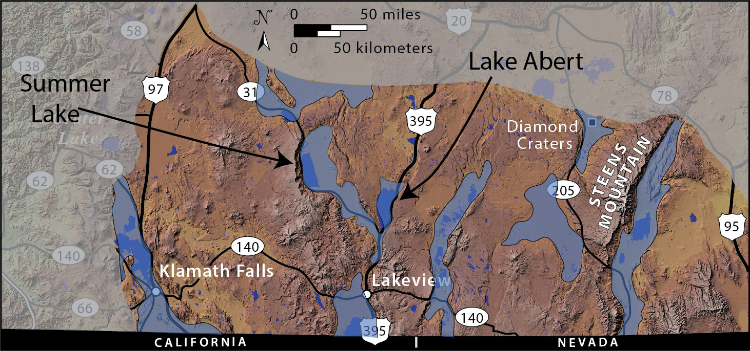
But think of what the lake was 20,000 years ago, at the height of the last glaciation!  The physiographic map below shows Lake Abert (along US 395) as part of the much larger Lake Chewaucan, which included the even larger Summer Lake basin to the west.  There’s all sorts of evidence for this earlier lake: old shorelines, deposits at elevations well above the modern lake, gravel bars.  And Lake Chewaucan was only one of many such Pleistocene, or “pluvial” lakes that occupied closed basins in the Oregon and Nevada Basin and Range.

Distribution of Pleistocene lakes in the southern Oregon Basin and Range.

Distribution of Pleistocene lakes in the southern Oregon Basin and Range.

Of course these ages do a “time-number” on me.  20,000 years is a short time, geologically.  So just yesterday, this region had many of these large large lakes –and in just a short time, they’ve dwindled to isolated remnants.  But in just the last 5 years, those remnants have dwindled even more.  It’s dramatic.  It’s frightening.

Odd too –those Young Earth Creation types think that planet Earth is younger than Lake Chewaucan!  And really?  Lake Chewaucan couldn’t have formed unless there was a basin there –and do you see the cliffs on the right (east) side of the lake?  That’s Abert Rim, uplifted by a big normal fault –which is what formed the basin.  So, the 2000′ of  uplift on this fault must be older than the lake, which is older than planet Earth!  Cool!


For more photos of Lake Abert, type “Lake Abert” into the geology search engine.
For information about the completely new (available in November, 2014) Roadside Geology of Oregon book.

Post Navigation

%d bloggers like this: