What a start to the new year! January 1, I flew home to Oregon with a north-facing window seat on a spectacularly clear day. So much incredible landscape! So much incredible geology! Here are nine photos I shot out the plane window, keyed to the geologic map below.
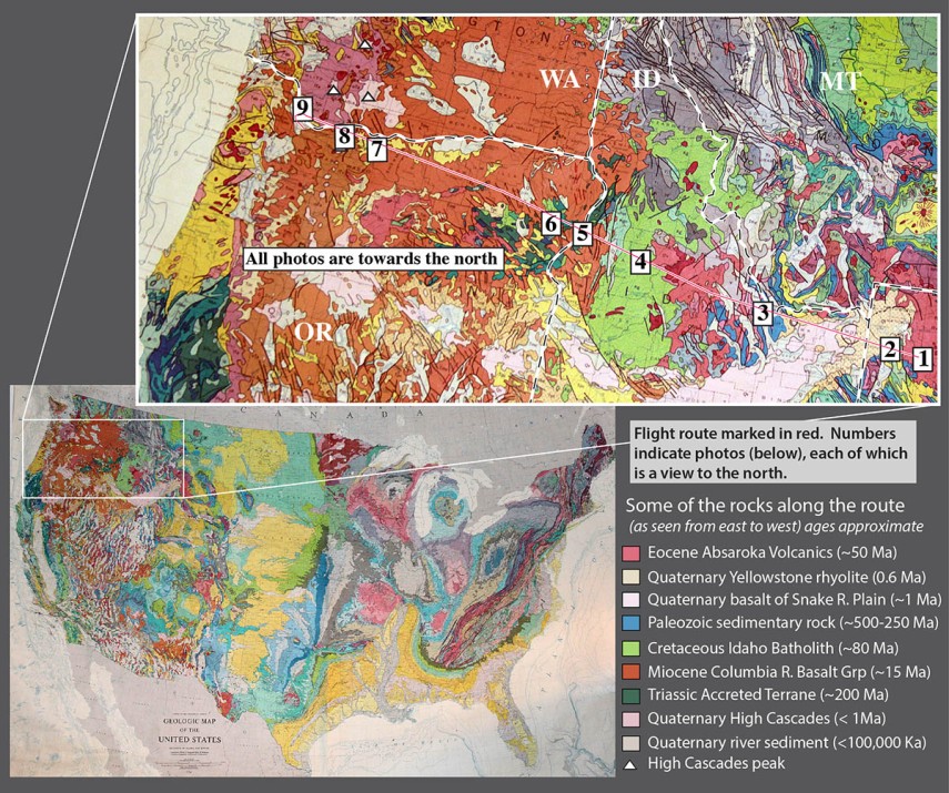
Photo 1. Absaroka Range, northern Wyoming and southern Montana. You can see that these mountains consist of layered rocks (see bottom of photo especially)–but they’re not sedimentary. They are basaltic to dacitic lava flows and pyroclastic rocks of the Absaroka Volcanic Field, erupted from about 53-43 million years ago. Much of the present topography is the result of glacial erosion during the Pleistocene.
Absaroka Range, east edge of Yellowstone Lake on left.
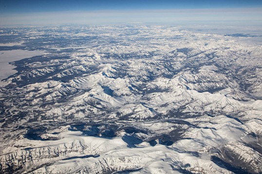
Photo 2. Yellowstone Lake. As you can see on the map, Yellowstone Lake fills only a fraction of the caldera created by Yellowstone’s Lava Creek Eruption, 600,000 years ago. Since then, rhyolite lavas, shown in pink, filled in the caldera. Notice the oval-shaped bay at the end of the lake’s western arm. It’s called West Thumb, and is a younger caldera that erupted about 150,000 years ago. It’s a caldera within a caldera! It’s pretty big too– almost identical in size to Crater Lake in Oregon –but compared to the main caldera, it’s tiny.
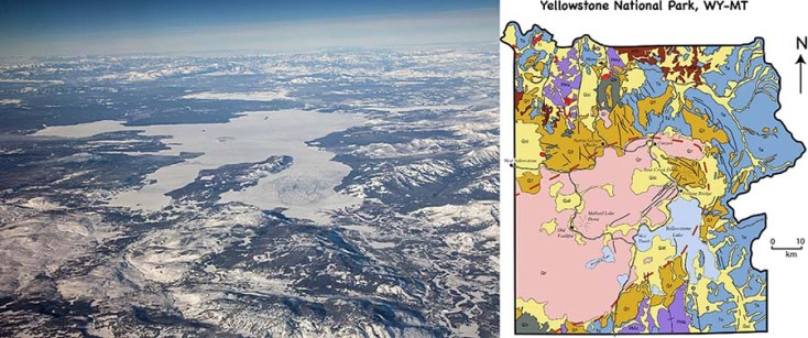
Photo and geologic map of Yellowstone National Park. The dashed red line marks the caldera edge.
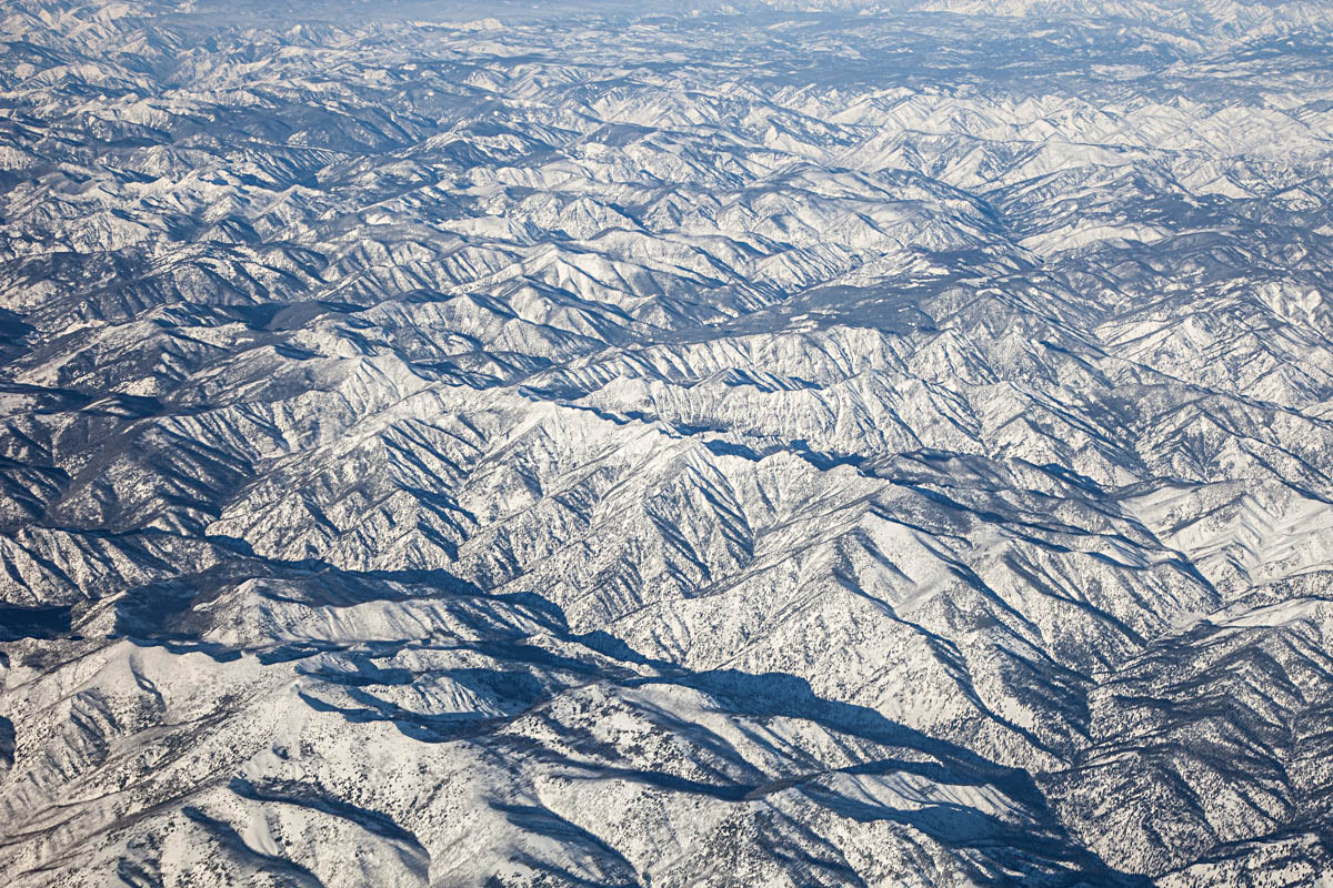
Photo 3. Recent faulting of the Basin and Range Province. In this photo, the Pahsimeroi River flows northwestward to its confluence with the Salmon River, near the left side of the photo –and the Salmon continues flowing northward for about 100 miles before it turns westward and eventually joins the Snake River.
Recent faulting along eastern edge of Pahsimeroi Valley, Idaho–and western front of Lemhi Range.
But what I think is so cool about this photo is that it so clearly shows the abrupt western edge of the Lemhi Range, which runs diagonally from the right (east) side of the photo to just above the center. The range literally rises right out of the ground. That abruptness is caused by faulting that takes place recently and frequently enough that erosion doesn’t keep up with it. The fault is a normal fault, caused by crustal extension. Notice the linear nature of the ranges to the northeast (upper right) –More normal faulting! This is a northern expression of the Basin and Range Province. Woohoo!
Photo 4. Mountains of the Idaho Batholith. Granitic rock of the Idaho Batholith underlies a huge area of Idaho, some 14,000 square miles of it. On the geologic map, it’s the big green area. The rock intruded as a series of plutons during the Late Cretaceous, from about 100 – 65 million years ago. Similar in age and composition to the Sierra Nevada Batholith, the Idaho Batholith was fed by magma created during subduction along the west coast of North America.

Mountains of the Idaho Batholith
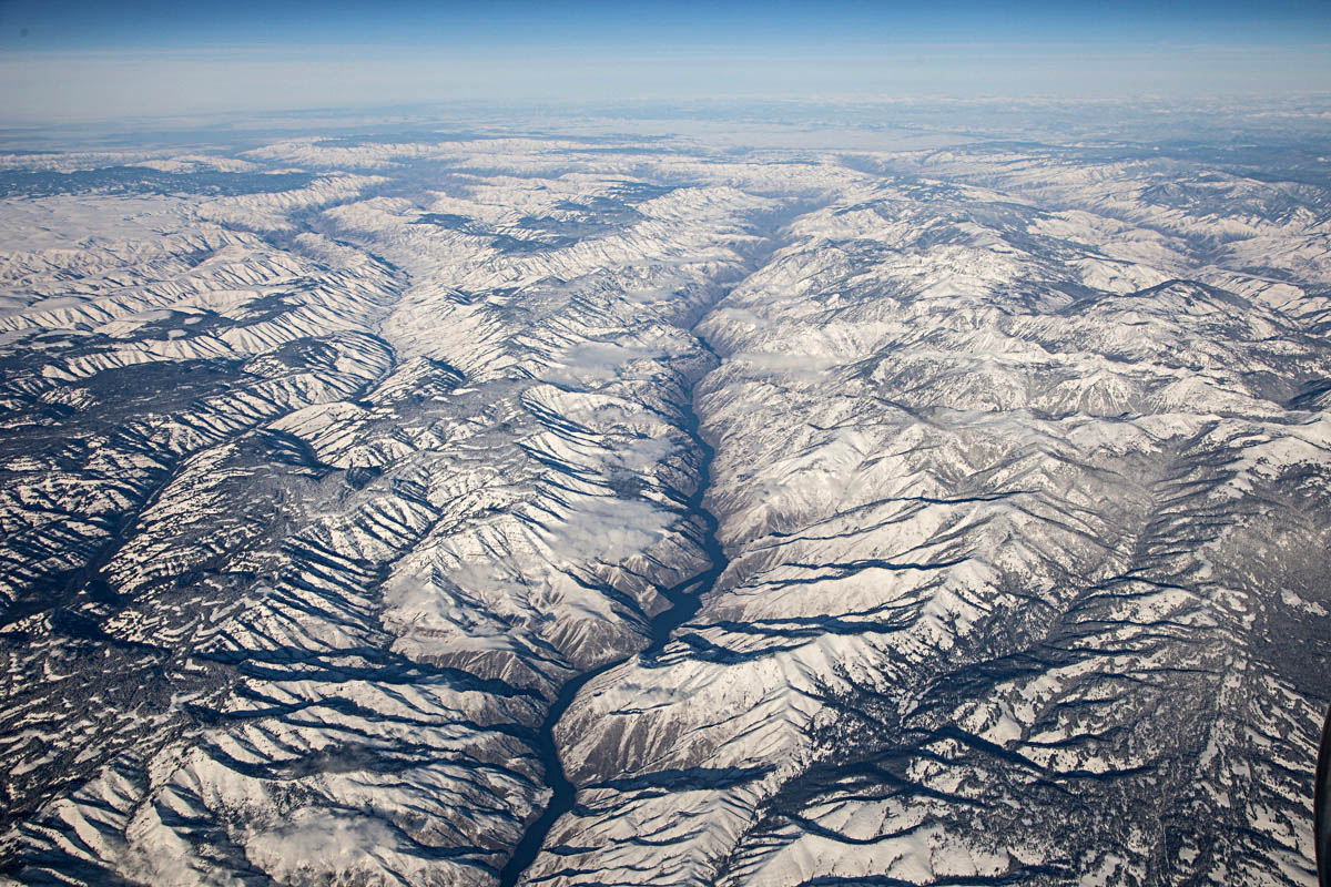
Photo 5. Hell’s Canyon. Not only does the north-flowing Snake River in Hell’s Canyon form the boundary between Idaho and Oregon (Yay, we made it to Oregon!), and not only is it the deepest canyon in the conterminous United States, but it’s also incredibly important from a geologic-history-of-western-North-America point-of-view.
Notice the flat areas above the canyon–they’re especially visible on the west (left) side, but you can also see them on the east. Those places are flat because they’re made of flat-lying basalt of the Columbia River Basalt Group. These basalts erupted mostly between 17-14.5 million years ago, but kept erupting off and on until about 6 million years ago –and they cover ALL of northern Oregon and ALL of southeastern Washington State. In fact, they flowed all the way to the Pacific Ocean.

Hell’s Canyon and the Snake River. The Imnaha River forms the next deep canyon to the left (west).
Those basalt flows overlie rock of the Wallowa accreted terrane: mostly volcanic and sedimentary rock that formed in an island arc setting, far offshore from North America. It was added (accreted) to the North American continent during the Mesozoic –probably some 150 million years ago.
Photo 6. Wallowa Mountains, Oregon. Just west of Hell’s Canyon are the Wallowa Mountains, Oregon’s premier alpine country outside of the Cascades. Like Hell’s Canyon, the Wallowas contain the accreted Wallowa terrane overlain by Columbia River Basalt –but the Wallowas also host the Wallowa Batholith, a Jurassic-Cretaceous granitic “stitching pluton”. It’s called a stitching pluton because it intrudes across accreted terranes and “stitched” them together.

Glacial valleys and frontal fault zone on the north side of the Wallowa Mountains, Oregon.
You can see a bunch of other things in this photo though. First off, the mountains end suddenly in a line: a recently active fault zone that has uplifted them more than 5000′ relative to the valley floor. Also, you can see how glaciers carved the landscape. Notice the deep U-shaped valleys, cirques, and knife-edged ridges called aretes. And see the lake in the upper right corner of the photo? It’s Wallowa Lake, dammed by a glacial moraine!
(at this point, the folks in the seats next to me wanted to throw me out of the airplane)
Photo 7. View of Washington High Cascades over The Dalles. That’s Mt. St. Helens on the left (west), Mt. Adams in the middle, and Mt. Rainier in the far distant right. Mt. Rainier is 90 miles away!
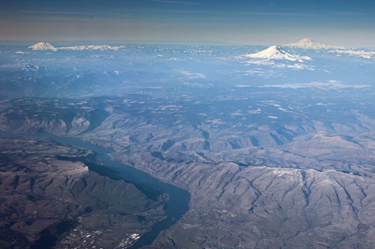
Looking north over the Dalles to Mts. St Helens, Rainier, and Adams.
These volcanoes are dormant –which means that they’re …sleeping? And they can awaken at any time. I remember a college friend of mine wanted to climb Mt. St. Helens in 1979. It was dormant then, and nobody worried about it. Then in May, 1980 it erupted violently, blowing off its top 2000′. Both St. Helens and Mt. Rainier have erupted many times in the past several thousand years; Mt. Adams though, erupted only twice in that period.
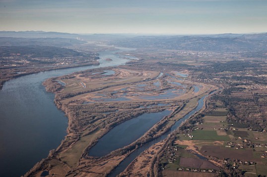
Photo 8. Columbia Gorge, the Washington High Cascades, and the Bonneville Landslide. From left (west) to right, the volcanoes are Mt. St. Helens, Mt. Rainier, and Mt. Adams. You can see the Bonneville Landslide along the river on the right side of the photo, directly below the left base of Mt. Adams. It detached from the cliffs directly behind it about 1450 A.D. and slid right into the river –and it pushed the river about a mile to the south! Just downriver from the landslide, you can see the Bonneville Dam zig-zagging across the river.

View northward over the Columbia River Gorge to the Washington High Cascades.
The ridges at the bottom of the photo lead up to Mt. Hood, another dormant stratovolcano and Oregon’s highest peak. Apparently, the view out the south side of the plane was even more ridiculously cool.
Photo 9. Columbia River, just below Portland. Right near Portland, the Columbia River turns northward for about 40 miles before it heads west again out towards the Pacific–and it drops only 10 feet in elevation for the whole distance. The northward deflection of the river is probably the result of uplift of the Portland Hills, which likely began as long as 16 million years ago (they also deflect 16 million year old lava flows of the Columbia River Basalt). That town along the river in the background is St. Helens, Oregon.
View northward, down the Columbia River, Washington on the right, Oregon on the left.
See more geologic photos of Oregon by typing “Oregon” into the geology search engine on my website –or type “Oregon, aerial” if you want to see aerial shots! And if you’re suddenly really excited about Oregon geology, please check out the new edition of Roadside Geology of Oregon!
Posted in
aerial geology,
aerial photography,
Geologic Time,
Geology,
Geology, Geologic Time,
geophotography,
mountains,
photography and tagged
Absaroka Mountains,
Absaroka Volcanics,
accreted terranes,
active faulting,
aerial geology,
aerial photo,
arete,
Basin and Range Province,
Bonneville Landslide,
Cascade Locks,
cirque,
Columbia River Basalt Group,
Columbia River Gorge,
dormant,
Earth Science,
fault,
geology,
glacial features,
granite,
Hell's Canyon,
High Cascade Volcanoes,
Idaho,
Idaho Batholith,
Imnaha River,
Lemhi Range,
moraine,
Mt. Adams,
Mt. Rainier,
Mt. St. Helens,
national park geology,
national parks,
normal fault,
Oregon,
Pahsimeroi Valley,
Portland,
recent fault,
Snake River,
U-shaped valley,
Wallowa Lake,
Wallowa Mountains,
Wallowa terrane,
Washington,
Wyoming,
Yellowstone,
Yellowstone caldera,
Yellowstone Lake