geologictimepics

Geology and Geologic Time through Photographs

Archive for the tag “national parks”

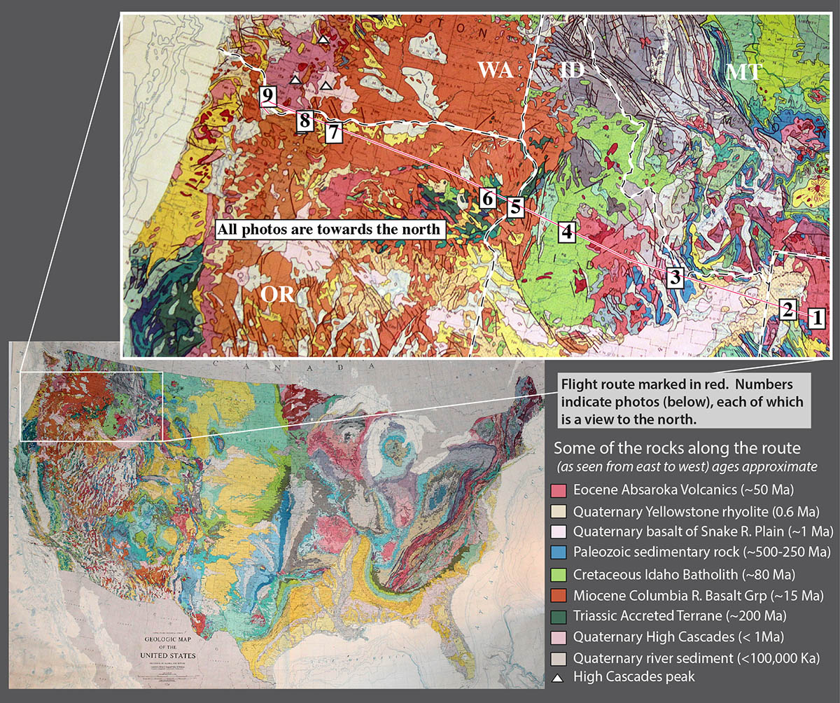
Landscape and Rock–4 favorite photos from 2015

Landscape and bedrock… seems we seldom connect the two. We all like beautiful landscapes, but most of us don’t ask how they formed –and even fewer of us think about the story told by the rocks that lie beneath it all. Those make two time scales, the faster one of landscape evolution and the much slower one of the rock record. Considering that we live in our present-day human time scale, it’s no wonder there’s a disconnect!

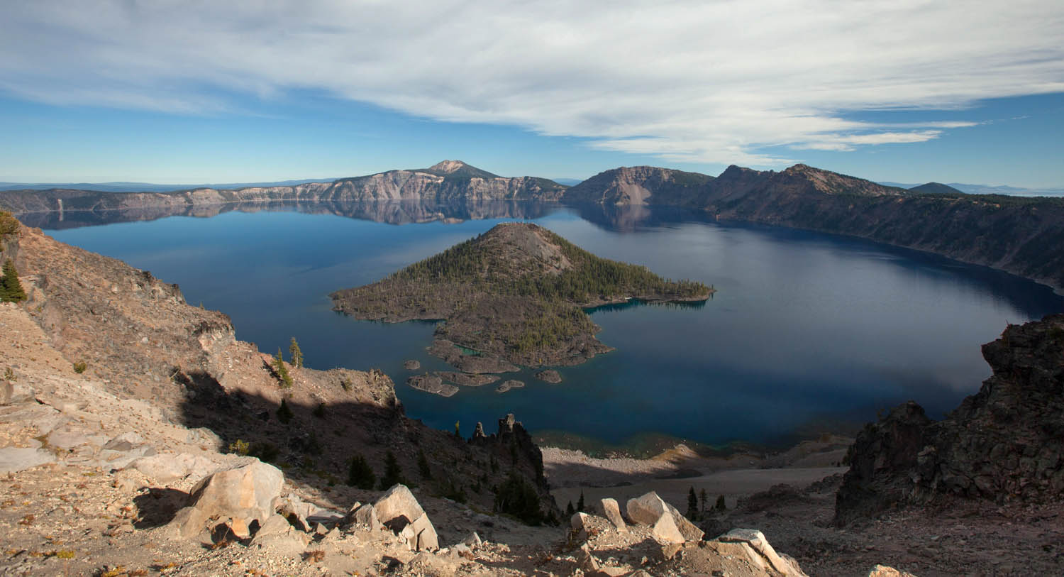
Take this photo of Mt. Shuksan in northern Washington. My daughter Meg and I drove up to the parking lot at Heather Meadows and went for a quick hike to stretch our legs and take some pictures just before sunset.We had about a half hour before the light faded –and all I could think about was taking a photo of this amazing mountain. But the geology? What??

151023-22

1. Mt. Shuksan and moonrise, northern Washington Cascades.

Thankfully, I’d been there in September scoping out a possible field project with a new grad student, and had the time to reflect… on time. From the ridge we hiked, shown as the dark area in the lower left corner of the left-hand photo below, we could almost feel Shuksan’s glaciers sculpting the mountain into its present shape. Certainly, that process is imperceptibly slow by human standards.

Shuksan combo

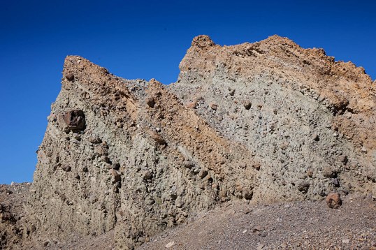
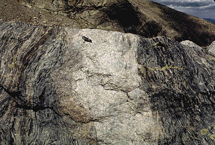
Mt. Shuksan: its glaciated NW side, summit, and outcrop of the Bell Pass Melange.

But the glaciers are sculpting bedrock –and that bedrock reveals its own story, grounded in a much longer time scale.

It turns out that the rock of Mt. Shuksan formed over tens of millions of years on three separate fragments of Earth’s lithosphere, called terranes. These terranes came together along faults that were then accreted to North America sometime during the Cretaceous. At the top of the peak you can find rock of the Easton Terrane. The Easton Terrane contains blueschist, a metamorphic rock that forms under conditions of high pressures and relatively low temperatures, such as deep in a subduction zone. Below that lies the Bell Pass Melange (right photo) –unmetamorphosed rock that is wonderfully messed up. And below that lies volcanic and sedimentary rock of the Chilliwack Group.

Here’s another of my favorites from 2015: the Keystone Thrust! It’s an easy picture to take –you just need to fly into the Las Vegas airport from the north or south, and you fly right over it. It’s the contact between the gray ledgey (ledgy? ledgeee?) rock on the left and the tan cliffs that go up the middle of the photo.

150427-57

2. Keystone Thrust fault, Nevada–gray Cambrian ridges over tan Jurassic cliffs.

The gray rock is part of the Cambrian Bonanza King Formation, which is mostly limestone, and the tan cliffs consist of  Jurassic Aztec Sandstone. Cambrian, being the time period from about 540-485 million years, is a lot older than the Jurassic, which spanned the time 200-145 million years ago. Older rock over younger rock like that requires a thrust fault.

Talk about geologic history… the thrust fault formed during a period of mountain building during the Cretaceous Period, some 100-70 million years ago, long before the present mountains. And the rocks? The limestone formed in a shallow marine environment and the sandstone in a sand “sea” of the same scale as today’s Sahara Desert. We know it was that large because the Aztec Sandstone is the same rock as the Navajo Sandstone in Zion and Arches national parks.

Cambrian-Jurassic

left: Limestone of the Cambrian Bonanza King Formation near Death Valley; right: Cross-bedded sandstone of the Jurassic Navajo Sandstone in Zion NP, Utah.

So… the photo shows cliffs and ledges made of rocks that tell a story of different landscapes that spans 100s of millions of years. But today’s cliffs and ledges are young, having formed by erosion of the much older rock.  Then I flew over it in about 30 seconds.

At Beach 2 near Shi Shi Beach in Washington State are some incredible sea stacks, left standing (temporarily) as the sea erodes the headlands. The sea stack and arch in the photo below illustrates the continuous nature of this erosion. Once the arch fails, the seaward side of the headland will be isolated as another sea stack, larger, but really no different than the sea stack to its left. And so it goes.

150912-42F

3. Sea arch and headland at Beach 2, Olympic Coast, Washington.

And of course, the headland’s made of rock that tells its own story –of  deposition offshore and getting scrunched up while getting added to the edge of the continent.

ShiShi

Bedrock at Beach 2 consists mostly of sandstone and breccia. The white fragment is limestone mixed with sandstone fragments.

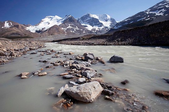
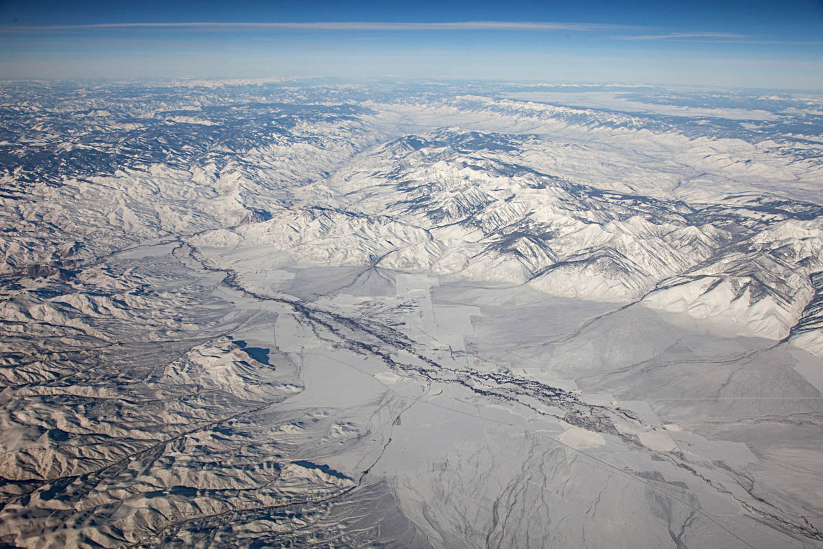
And finally, my last “favorite”. It’s of an unnamed glacial valley in SE Alaska. My daughter and I flew by it in a small plane en route to Haines, Alaska to visit my cousin and his wife. More amazing landscape–carved by glaciers a long time ago. But as you can expect, the rock that makes it up is even older and tells it’s own story.

150616-119

4. Glacial Valley cutting into Chilkat Mountains, SE Alaska.

Of course, this message of three time scales, the human, the landscape, and the rock-record time scale applies everywhere we go. Ironically, we’re usually in a hurry. I wish I kept it in mind more often, as it might slow me down a little.

Here’s to 2015 –and to 2016.

To see or download these four images at higher resolutions, please visit my webpage: favorite 10 geology photos of 2015.


Conglomerate!

A trip to Death Valley over Thanksgiving two weeks ago reignited all sorts of things in my brain, one of which being my love of conglomerate. Honestly, conglomerate HAS to be the coolest rock!

151128-3

Tilted conglomerate in Furnace Creek Wash, Death Valley.

Just look at this stuff! Just like any good clastic sedimentary rock, it consists of particles of older rock–but with conglomerate, you can easily see those particles. Each of those particles opens a different door to experiencing deep geologic time.

As an example, look at the conglomerate below, from the Kootenai Formation of SW Montana. It contains many different cobbles of light gray and dark gray quartzite and pebbles of black chert. The quartzite came the Quadrant Formation and chert from the Phosphoria Formation. So just at first glance, you can see that this conglomerate in the Kootenai contains actual pieces of two other older rock units.

3528-38lr

Conglomerate of the Kootenai Formation, SW Montana.

But consider this: The Quadrant formed as coastal sand dunes during the Pennsylvanian Period, between about 320-300 million years ago and the Phosphoria chert accumulated in a deep marine environment during the Permian, from about 300-250 million years ago. The Kootenai formed as river deposits during the early part of the Cretaceous Period, about 120 million years ago. All those are now together as one.

Similar to the modern river below (except for the glaciers), the Kootenai rivers transported gravel away from highlands –the highlands being made of much older rock that was uplifted and exposed to erosion. That older rock speaks to long gone periods of Earth history while the gravel speaks to the day it’s deposited.

120709-123

Athabasca River in Jasper National Park, Alberta

But this is where my head starts to spin: the modern gravel is made of rounded fragments of old rock –so when you look at a conglomerate, you glimpse at least two time periods at once: you see the conglomerate, which reflects a river or alluvial fan –or any environment near a bedrock source– and you also see the particles, which formed in even older environments.

And it gets worse –or better. What happens when you see a conglomerate eroding? The conglomerate is breaking up into modern sediment, which consists of pieces of older sediment –that at one time was modern sediment that used to be older sediment?  Look at the pebbles below. I keep them in a rusty metal camping cup on a table in my office.

151209-4

“Recycled” pebbles of the Kootenai Formation.

These stream pebbles eroded out of the Kootenai conglomerate. So… they’re simultaneously modern stream pebbles and ancient ones –AND… they originated as the Quadrant and Phosphoria Formations. Four periods of time, spanning 300 million years, all come together at once.

And if that’s not enough, those conglomerates in Death Valley? They  contain particles of… conglomerate! Look! The arrow in the left photo points to the boulder of conglomerate on the right. If you click on the photos, you can see them enlarged.

All those particles, which are now eroding and becoming modern sediment, were yesterday’s sediment. And the conglomerate boulder? It too is becoming “modern sediment” and it too was “yesterday’s sediment” when it was deposited on an alluvial fan with the rest of the material. However, it goes a step further: its pebbles and cobbles were both “modern” and “yesterday’s” sediment at a still older time. And before that? Those pebbles and cobbles eroded from even older rock units, some of which date from the Cambrian, about 500 million years ago.

For fun, here’s a photo of another conglomerate boulder.

Conglomerate clast in conglomerate

Conglomerate boulder in conglomerate of the Furnace Creek Formation, Death Valley, CA.


I can’t help but wonder how Young Earth Creationists would deal with these rocks. Given their story of the Grand Canyon, in which the Paleozoic section was deposited during early stages of “The Flood” and the canyon was carved during the later stages (they really do say that too!), they’d probably roll out that same blanket answer: The Flood. End of discussion. No questioning, no wondering.

In my opinion, one of the beautiful things about geology is that we’re always questioning and wondering.


for more geology photos, please visit my website.


Death Valley National Park– Geology Overload!

Death Valley… I can’t wait! Tomorrow this time, I’ll be walking on the salt pan with my structural geology students, gawking at the incredible mountain front –and soon after that, we’ll be immersed in fault zones, fractures, and fabrics!

Death Valley salt pan at sunrise.

Death Valley salt pan at sunrise.

Death Valley presents incredible opportunities for all sorts of geology, especially geologic time; you can look just about anywhere to see and feel it.  Take the salt pan.  It really is salt –you can sprinkle it on your sandwich if you want.  It’s there because the valley floor periodically floods with rainwater.  As the rainwater evaporates, dissolved salt in the water precipitates.  And some 10,000 years ago, Death Valley was filled by a 600′ deep lake, which evaporated, leaving behind more salt. Before that, more shallow flooding and more lakes.

Aerial view of faulted front of the Black Mountains.

Aerial view of faulted front of the Black Mountains.

But the basin is more than 4 miles deep in some places! It’s not all salt, because there are a lot of gravel and sand deposits, but a lot of it is salt.  That depth speaks to geologically fast accumulation rates, because it all had to accumulate since Death Valley formed –probably in the last 2 or 3 million years.  But still, 2 or 3 million years is way past our realm of experience.

Hiker in the Funeral Mountains of Death Valley.

Hiker in the Funeral Mountains of Death Valley.

To really go back in geologic time though, you need to look at the mountains. Most of the mountains contain Upper Precambrian through Paleozoic sedimentary rock, most of which accumulated in shallow marine environments.  There’s a thickness of more than 30,000 feet of sedimentary rock exposed in Death Valley! Deposited layer after layer, you can only imagine how long that took.

We can measure the thickness of the rock because it’s no longer in its original horizontal position.  The ones in the photo above were tilted by faulting –which occurred during the period of crustal extension that formed Death Valley today.  The rocks in the photo below were folded –by a period of crustal shortening that took place long before the modern extension.  The folding occurred during the Mesozoic Era –more than 65 million years ago.

Aerial view of Titus Canyon Anticline.

Aerial view of Titus Canyon Anticline.

Above the Upper Precambrian to Paleozoic rock are thousands of feet of volcanic and sedimentary rock, tilted and faulted, but not folded. They reveal many of the details of the crustal extension that eventually formed today’s landscape.  For example, the photo below shows Ryan Mesa in upper Furnace Creek Wash.  In this place, the main period of extensional faulting predates the formation of modern Death Valley.  Look at the photo to see that faulting must have stopped before eruption of the dark-colored basalt flows.  Notice that there has to be a fault underneath the talus cones that separates the Artist Dr. Formation on the left from the Furnace Creek Formation on the right.  Because the fault does not cut the basalt though, it has to be older.  Those basalts are 4 million years old, older than modern Death Valley.  –And that’s the old mining camp of Ryan perched on the talus.

Angular unconformity at Ryan Mesa: 4 Ma basalt flows overlying faulted Artist Drive (left) and Furnace Creek (right) formations.

Angular unconformity at Ryan Mesa: 4 Ma basalt flows overlying faulted Artist Drive (left) and Furnace Creek (right) formations.

And beneath it all? Still older rock!  There’s some 5,000 feet of even older Precambrian sedimentary rock, called the “Pahrump Group” beneath the 30,000 feet of Upper Precambrian and Paleozoic rock–and below that, Precambrian metamorphic rock.  It’s called the “basement complex” because it’s the lowest stuff.  Here’s a photo.

pegmatite dike and sill intruding mylonitic gneiss

pegmatite dike and sill intruding gneiss

The pegmatite (the light-colored intrusive rock) is actually quite young–I think our U-Pb age was 55 Ma –but the gneiss is much older, with a U-Pb age of 1.7 billion years.  Billion!  Forget about the U-Pb age though.  These rocks form miles beneath Earth’s surface –and here they are, at the surface for us to see. Without knowing their age, you’re looking at deep geologic time because of the long period of uplift and erosion required to bring them to the surface.  And it happened before all those other events that described earlier.

THIS is why, when visiting Death Valley, you need to explore the canyons and mountains –not to mention the incredible views, silence, stillness…


Some links:
Geologic map of Death Valley for free download
Slideshow of Death Valley geology photos

–or better yet, type “Death Valley” into the geology photo search function on my website!

Geologic field trip from Yellowstone Lake to Portland, Oregon at 30,000 feet

What a start to the new year!  January 1, I flew home to Oregon with a north-facing window seat on a spectacularly clear day.  So much incredible landscape!  So much incredible geology!  Here are nine photos I shot out the plane window, keyed to the geologic map below.

Yel-PDX + US map

Photo 1.  Absaroka Range, northern Wyoming and southern Montana.  You can see that these mountains consist of layered rocks (see bottom of photo especially)–but they’re not sedimentary.  They are basaltic to dacitic lava flows and pyroclastic rocks of the Absaroka Volcanic Field,  erupted from about 53-43 million years ago.  Much of the present topography is the result of glacial erosion during the Pleistocene.

Absaroka Range, east edge of Yellowstone Lake on left.

Absaroka Range, east edge of Yellowstone Lake on left.

Photo 2.  Yellowstone Lake.  As you can see on the map, Yellowstone Lake fills only a fraction of the caldera created by Yellowstone’s Lava Creek Eruption, 600,000 years ago.  Since then, rhyolite lavas, shown in pink, filled in the caldera.  Notice the oval-shaped bay at the end of the lake’s western arm.  It’s called West Thumb, and is a younger caldera that erupted about 150,000 years ago.  It’s a caldera within a caldera!  It’s pretty big too– almost identical in size to Crater Lake in Oregon –but compared to the main caldera, it’s tiny.

Photo and geologic map of Yellowstone National Park

Photo and geologic map of Yellowstone National Park. The dashed red line marks the caldera edge.

Photo 3. Recent faulting of the Basin and Range Province. In this photo, the Pahsimeroi River flows northwestward to its confluence with the Salmon River, near the left side of the photo –and the Salmon continues flowing northward for about 100 miles before it turns westward and eventually joins the Snake River.

Recent faulting along western edge of Lemhi Range, Idaho.

Recent faulting along eastern edge of Pahsimeroi Valley, Idaho–and western front of Lemhi Range.

But what I think is so cool about this photo is that it so clearly shows the abrupt western edge of the Lemhi Range, which runs diagonally from the right (east) side of the photo to just above the center.  The range literally rises right out of the ground.  That abruptness is caused by faulting that takes place recently and frequently enough that erosion doesn’t keep up with it.  The fault is a normal fault, caused by crustal extension.  Notice the linear nature of the ranges to the northeast (upper right) –More normal faulting!  This is a northern expression of the Basin and Range Province.  Woohoo!

Photo 4. Mountains of the Idaho Batholith.  Granitic rock of the Idaho Batholith underlies a huge area of Idaho, some 14,000 square miles of it. On the geologic map, it’s the big green area.  The rock intruded as a series of plutons during the Late Cretaceous, from about 100 – 65 million years ago.  Similar in age and composition to the Sierra Nevada Batholith, the Idaho Batholith was fed by magma created during subduction along the west coast of North America.

Mountains of the Idaho Batholith

Mountains of the Idaho Batholith

Photo 5. Hell’s Canyon.  Not only does the north-flowing Snake River in Hell’s Canyon form the boundary between Idaho and Oregon (Yay, we made it to Oregon!), and not only is it the deepest canyon in the conterminous United States, but it’s also incredibly important from a geologic-history-of-western-North-America point-of-view.

Notice the flat areas above the canyon–they’re especially visible on the west (left) side, but you can also see them on the east.  Those places are flat because they’re made of flat-lying basalt of the Columbia River Basalt Group. These basalts erupted mostly between 17-14.5 million years ago, but kept erupting off and on until about 6 million years ago –and they cover ALL of northern Oregon and ALL of southeastern Washington State.  In fact, they flowed all the way to the Pacific Ocean.

Hell's Canyon and the Snake River.

Hell’s Canyon and the Snake River. The Imnaha River forms the next deep canyon to the left (west).

Those basalt flows overlie rock of the Wallowa accreted terrane: mostly volcanic and sedimentary rock that formed in an island arc setting, far offshore from North America.  It was added (accreted) to the North American continent during the Mesozoic –probably some 150 million years ago.

Photo 6. Wallowa Mountains, Oregon. Just west of Hell’s Canyon are the Wallowa Mountains, Oregon’s premier alpine country outside of the Cascades.  Like Hell’s Canyon, the Wallowas contain the accreted Wallowa terrane overlain by Columbia River Basalt –but the Wallowas also host the Wallowa Batholith, a Jurassic-Cretaceous granitic “stitching pluton”.  It’s called a stitching pluton because it intrudes across accreted terranes and “stitched” them together.

Glacial valleys and frontal fault zone on the north side of the Wallowa Mountains, Oregon.

Glacial valleys and frontal fault zone on the north side of the Wallowa Mountains, Oregon.

You can see a bunch of other things in this photo though.  First off, the mountains end suddenly in a line: a recently active fault zone that has uplifted them more than 5000′ relative to the valley floor. Also, you can see how glaciers carved the landscape.  Notice the deep U-shaped valleys, cirques, and knife-edged ridges called aretes.  And see the lake in the upper right corner of the photo?  It’s Wallowa Lake, dammed by a glacial moraine!

(at this point, the folks in the seats next to me wanted to throw me out of the airplane)

Photo 7. View of Washington High Cascades over The Dalles.  That’s Mt. St. Helens on the left (west), Mt. Adams in the middle, and Mt. Rainier in the far distant right.  Mt. Rainier is 90 miles away!

Looking north over the Dalles to Mts. St Helens, Rainier, and Adams.

Looking north over the Dalles to Mts. St Helens, Rainier, and Adams.

These volcanoes are dormant –which means that they’re …sleeping?  And they can awaken at any time.  I remember a college friend of mine wanted to climb Mt. St. Helens in 1979.  It was dormant then, and nobody worried about it.  Then in May, 1980 it erupted violently, blowing off its top 2000′.  Both St. Helens and Mt. Rainier have erupted many times in the past several thousand years; Mt. Adams though, erupted only twice in that period.

Photo 8.  Columbia Gorge, the Washington High Cascades, and the Bonneville Landslide.  From left (west) to right, the volcanoes are Mt. St. Helens, Mt. Rainier, and Mt. Adams.  You can see the Bonneville Landslide along the river on the right side of the photo, directly below the left base of Mt. Adams.  It detached from the cliffs directly behind it about 1450 A.D. and slid right into the river –and it pushed the river about a mile to the south! Just downriver from the landslide, you can see the Bonneville Dam zig-zagging across the river.

View northward over the Columbia River Gorge to the Washington High Cascades.

View northward over the Columbia River Gorge to the Washington High Cascades.

The ridges at the bottom of the photo lead up to Mt. Hood, another dormant stratovolcano and Oregon’s highest peak.  Apparently, the view out the south side of the plane was even more ridiculously cool.

Photo 9. Columbia River, just below Portland.  Right near Portland, the Columbia River turns northward for about 40 miles before it heads west again out towards the Pacific–and it drops only 10 feet in elevation for the whole distance.  The northward deflection of the river is probably the result of uplift of the Portland Hills, which likely began as long as 16 million years ago (they also deflect 16 million year old lava flows of the Columbia River Basalt). That town along the river in the background is St. Helens, Oregon.

View northward, down the Columbia River.

View northward, down the Columbia River, Washington on the right, Oregon on the left.


See more geologic photos of Oregon by typing “Oregon” into the geology search engine on my website –or type “Oregon, aerial” if you want to see aerial shots!  And if you’re suddenly really excited about Oregon geology, please check out the new edition of Roadside Geology of Oregon!

Crater Lake caldera, Oregon –some things happen quickly!

Crater Lake never ceases to amaze me.  It’s huge –some 6 miles (10 km) across, deep –some 1700 feet deep in parts –the deepest lake in the United States and 7th deepest on the planet– incredibly clear, and really really blue.  And for volcano buffs, one of the best places ever!

Crater Lake as seen from The Watchman.  Wizard Island, which formed after the caldera collapse, occupies the center of the photo.

Crater Lake as seen from The Watchman. Wizard Island, which formed after the caldera collapse, occupies the center of the photo.

Crater Lake is a caldera, formed when ancient Mt. Mazama erupted so catastrophically that it emptied its magma chamber sufficiently for the overlying part of the mountain to collapse downward into the empty space.  That was about 7700 years ago.  Soon afterwards, Wizard Island formed, along with some other volcanic features that are now hidden beneath the lake–and then over the years, the lake filled to its present depth.  It’s unlikely to rise any higher because there is a permeable zone of rock at lake level that acts as a drain.

Here’s one of the coolest things about the cataclysmic eruption: Not only was it really big, but it happened really fast.  We know it was big because we can see pumice, exploded out of the volcano, blanketing the landscape for 100s of square miles to the north of the volcano –and we can see the caldera.  We can tell it happened quickly because the base of the pumice is welded onto a rhyolite flow that erupted at the beginning stages of the collapse; the rhyolite was still HOT when the pumice landed on it!  You can see the welded pumice on top the Cleetwood Flow along the road at Cleetwood Cove.

pumice welded onto top of Cleetwood rhyolite flow at Cleetwood Cove.  Note how the base of the pumice is red from oxidation --and forms a ledge because it's so hard.

pumice welded onto top of Cleetwood rhyolite flow at Cleetwood Cove. Note how the base of the pumice is red from oxidation –and forms a ledge because it’s so hard.  Pumice blankets the landscape all around Crater Lake.

Crater Lake though, is so much more than a caldera –it’s the exposed inside of a big stratovolcano!  Where else can you see, exposed in beautiful natural cross-sections, lava flow after lava flow, each of which erupted long before the caldera collapse and built the original volcano? Within the caldera itself, these flows go back 400,000 years–the oldest ones being those that make up Phantom Ship –the cool little island (some 50′ tall) in Crater Lake’s southeast corner.

Phantom Ship, in Crater Lake's southeast corner, is made of the caldera's oldest known rock, at 400,000 years old.

Phantom Ship, in Crater Lake’s southeast corner, is made of the caldera’s oldest known rock, at 400,000 years old.

I can’t resist.  The caldera formed about 7700 years ago, incredibly recent in Earth history–incredibly recent in just the history of Mt. Mazama!  To a young earth creationist though, that’s 1700 years before Earth formed.  Now THAT’S amazing!


Click here if you want to see a Geologic map of Crater Lake.
Or… for more pictures of Crater Lake, type its name into the Geology Search Engine.  Or… check out the new Roadside Geology of Oregon book!

Glacially carved granite in Rocky Mountain National Park, Colorado

This landscape is so smooth and rounded that you can easily imagine the ice that must have covered it some 20,000 years ago.  And the ice must have been deep!  Look halfway up the mountain in the foreground on the left; it shows a distinct change of rock weathering akin to a bathtub ring–and the ring persists around much of the photo.  It likely marks the upper surface of the ice at maximum glaciation.

140809-94
Upper Glacier Gorge, a glacial cirque in Rocky Mountain National Park, Colorado.  View of the Spearhead (left) and McHenry’s Peak (just behind)

Like most landscapes, this one’s pretty young–and those glacial effects are even younger.  When compared to the age of the rock, it seems almost insignificant.  The granite bedrock, which is granite, is 1.4 billion years old!  Elsewhere in Rocky Mountain National Park, the granite intrudes even older metamorphic rock –1.7 billion years old.  Just .3 billion years older.  I think we forget that “just .3 billion years” is 300 million years –about the same length of time as the entire Paleozoic!  And the Pleistocene Epoch, during which the glaciers grew?  It started some 2 million and ended about 10,000 years ago

Granite sill intruding gneiss, Colorado.
1.4 billion year old granite intruding 1.7 billion year old gneiss in Rocky Mtn National Park.


images can be downloaded for free at marlimillerphoto.com

San Andreas Fault

Here’s a view of the San Andreas fault and Pt. Reyes in northern California, looking northward.  The fault runs right up the narrow Tomales Bay–and in just a few miles, runs along the edge of San Francisco.

The San Andreas fault is amazingly well-studied –it’s probably the most-studied fault zone in the world.  After all, it is capable of generating huge earthquakes in heavily populated areas, so the more we know about it the better.

San Andreas fault and Tomales Bay

Aerial view of San Andreas fault and Pt. Reyes --just north of San Francisco. View is to the north. The fault runs down Tomales Bay, the narrow arm of the ocean that runs diagonally across the photo.

One thing we know about the San Andreas is that it generally moves in a side-by-side way (strike-slip) so that rock on the east side moves south relative to that on the west side.  And over time, the fault has moved the eastern rock more than 300km relative to the western rock.

Now, 300 km –that speaks to millions of years of geologic time.  We can measure the rate at which the Pacific Plate moves relative to the North American Plate –about 4.5 cm/year.  The San Andreas takes up most of that –but not all.  But if we assume it takes it all, we’re looking at a total of 300km at 4.5cm/year –so at least 6.6 million years.

Of course… if you think planet Earth is only 10,000 years old, that means the fault’s moved some 300 meters (3 football fields) every 10 years.  And considering that the displacement was about 6 meters during the M 8.3 1906 San Francisco Earthquake…that’s a lot of earthquakes in just a short period of time!

Or another way of putting it, if planet Earth were 10,000 years old AND the San Andreas fault formed at the very beginning, 10,000 years ago… then there must have been 50 of those San-Francisco-sized Earthquakes every ten years –or… 5 of those every year.  Yikes!

But of course… we know that the San Andreas isn’t as old as the planet.  It cuts that granite at Pt. Reyes… which is related to the Sierra Nevada granite –which is really pretty young –but older than 10,000 years by about 100 million.

click here if you want to see more photos of the San Andreas fault –with a map!

Great Unconformity –in the Teton Range, Wyoming

As it turns out, the “Great Unconformity”, the contact between Cambrian sedimentary rock and the underlying Precambrian basement rock, is a regional feature –it’s not only in the Grand Canyon, but found all over the Rocky Mountain West –and for that matter, it’s even in the midwest.  As an example, here are a couple photos from the Teton Range in Wyoming.

The yellow arrow points to the contact between the Cambrian Sandstone and underlying Precambrian metamorphic rock... the Great unconformity.

This top photo shows the Grand Teton (right) and Mt. Owen (left) in the background… in the foreground, you can see a flat bench, which is underlain by flat-lying Cambrian sandstone.  Below that are darker-colored cliffs of Precambrian metamorphic rock.  The unconformity is right at their contact (arrow).

Also notice that the Grand Teton and Mt. Owen are made of metamorphic (and igneous) rock –but they’re much much higher in elevation than the sandstone.  That’s because there’s a fault, called the “Buck Mountain fault” that lies in-between the two.  The Buck Mountain fault moved the rock of the high peaks over the ones in the foreground during a mountain-building event at the end of the Mesozoic Era.  Because the metamorphic and igneous rock is so much more resistant to erosion than the sandstone, it stands up a lot higher.

Precambrian metamorphic and igneous rock of the Teton Range and overlying sedimentary rock.

This lower photo shows the view of the Teton range from the top of the sandstone bench (appropriately called “Table Mountain”).  As you look eastward towards the range, you can pick out the Buck Mountain fault (between the metamorphic and igneous rock of the high peaks) and the Cambrian sedimentary rock (the layered rocks).  Significantly, the Cambrian rocks, just like in the Grand Canyon, consist of sandstone, overlain by shale, overlain by limestone.

And geologic time… remember… for the sandstone to be deposited on the metamorphic or igneous rock, the metamorphic and igneous rock had to get uplifted from miles beneath the surface and exposed at sea level.  And since then, it’s been uplifted to the elevation of The Grand Teton (13370′) and Mt. Owen (12, 928′) !

Click here to see more photos of unconformities.
or… click here to see a geologic map of Grand Teton National Park, Wyoming.

Post Navigation

%d bloggers like this: