geologictimepics

Geology and Geologic Time through Photographs

Archive for the category “geologic hazards”

Sampling New Zealand’s (Amazing) Geology

New Zealand’s landscape can make just about anybody appreciate geology. Its glaciated peaks, its coastline –that ranges from ragged cliffs to sandy beaches to glacial fjords– its active volcanoes… they all work together to shout “Earth Science!” With that in mind, here’s some basics of New Zealand’s amazing geology, followed by some geological highlights of my trip of January and early February, 2018.

NZ map--all

Map of New Zealand, showing accreted terranes in colors and cover assemblage in gray. (Compiled mostly from Graham, 2015)

North and South Island Bedrock  The different colors on this map show New Zealand’s basement rock, named so because it forms the lowest known bedrock foundation of any given area. The basement tells stories of New Zealand’s deep past, from about 500-100 million years ago. Individual colors signify different terranes, accreted (added) one-by-one through plate motions to the edge of what was then the supercontinent Gondwana. They mostly consist of sedimentary and metamorphosed sedimentary rock, although the narrow belt of purple-colored Dun Mountain Ophiolite formed as oceanic lithosphere, and the red-colored areas consist of granitic igneous rock, some of which has been metamorphosed to gneiss.

Gray indicates the younger cover rock, formed after accretion of the terranes. Consisting of a wide range of sedimentary and volcanic rocks, as well as recently deposited sediment, it’s just as interesting and variable as the terranes. Because it includes volcanoes, it’s largely the cover that gives the North Island its distinctive flair. By contrast, the South Island consists largely of uplifted basement rock, much of which has been –and still is—glaciated. All those long deep lakes, such as Lakes Wanaka and Tekapo, were carved by glaciers and are now floored with their deposits of till.

Andesite stratovolcano, New Zealand

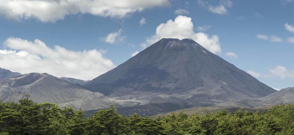
Mt. Ngauruhoe, a 7000 year-old andesite stratocone near Ruapehu on the North Island

Those differences exist largely because the North and South Islands occupy different plate tectonic settings. The North Island sits over a subduction zone, so it hosts an active Read more…

Geologypics.com– A new (and free) resource for geological photographs

What better way to kick off my new website than to write about it on my blog? To see it, you just need to click on the word “home” in the space above. Or you can click the link: geologypics.com.

Here’s part of the front page:
home3

As it says, the site offers free downloads for instructors –and for anybody who’s craving a good geology photograph. It’s my way of contributing to geology education –showing off some of our landscape’s amazing stories and providing resources for other folks who want to do the same.

I think the best part of the whole site is that red button in the middle of the home page. It says “Image Search by Keyword”.

Right now, there are more than 2200 images you can search for — all of which are downloadable at resolutions that generally work for powerpoint. If you search for “sea stack” for example, you’ll get 38 hits –and the page will look like this:

Sea Stack search

First page of sea stacks when you search on the term.


Notice that ALL the photos are presented as squares–which works for most photos, but not all. To help mitigate that, the photos with vertical or panorama formats say so in their title, so you know to click on them to see the whole image. Take the photo in the upper center, for example –it’s got a  vertical format. Here it is:vertial image


A more detailed caption below the photo, along with its ID number appears at the bottom of the pic. This particular image is the chapter opener to the Coast Range in my new book “Roadside Geology of Washington“, which I wrote with Darrel Cowan of University of Washington.

There are also galleries –a chance to browse a variety of images without having to think of keywords. Similar to the search, they’re presented as squares so you need to click on the photo to see the whole thing.


Here’s what the photo gallery page looks like (on the left), followed by part of the “glaciation” page you’d see if you clicked on “glaciation”.  Woohoo!

galleries

part of Galleries page (left) and part of Glacial page (right)


Then there’s the “About” page, which gives some information about me and details my policies regarding use of the images (basically, you can download freely for your personal, non-commercial use if you give me credit; if you want to use the image in a commercial publication you need to contact me to negotiate fees). There’s also a “News” page, that gives updates on the website. There’s a contact page from which you can send me emails. And the blog? It goes right back to here!

And finally, if you’re looking for a great web designer? Try Kathleen Istudor at Wildwood SEO –she created the site and spent hours coaching me on how to manage it.

Enjoy the site!


Crater Lake caldera, Oregon –some things happen quickly!

Crater Lake never ceases to amaze me.  It’s huge –some 6 miles (10 km) across, deep –some 1700 feet deep in parts –the deepest lake in the United States and 7th deepest on the planet– incredibly clear, and really really blue.  And for volcano buffs, one of the best places ever!

Crater Lake as seen from The Watchman.  Wizard Island, which formed after the caldera collapse, occupies the center of the photo.

Crater Lake as seen from The Watchman. Wizard Island, which formed after the caldera collapse, occupies the center of the photo.

Crater Lake is a caldera, formed when ancient Mt. Mazama erupted so catastrophically that it emptied its magma chamber sufficiently for the overlying part of the mountain to collapse downward into the empty space.  That was about 7700 years ago.  Soon afterwards, Wizard Island formed, along with some other volcanic features that are now hidden beneath the lake–and then over the years, the lake filled to its present depth.  It’s unlikely to rise any higher because there is a permeable zone of rock at lake level that acts as a drain.

Here’s one of the coolest things about the cataclysmic eruption: Not only was it really big, but it happened really fast.  We know it was big because we can see pumice, exploded out of the volcano, blanketing the landscape for 100s of square miles to the north of the volcano –and we can see the caldera.  We can tell it happened quickly because the base of the pumice is welded onto a rhyolite flow that erupted at the beginning stages of the collapse; the rhyolite was still HOT when the pumice landed on it!  You can see the welded pumice on top the Cleetwood Flow along the road at Cleetwood Cove.

pumice welded onto top of Cleetwood rhyolite flow at Cleetwood Cove.  Note how the base of the pumice is red from oxidation --and forms a ledge because it's so hard.

pumice welded onto top of Cleetwood rhyolite flow at Cleetwood Cove. Note how the base of the pumice is red from oxidation –and forms a ledge because it’s so hard.  Pumice blankets the landscape all around Crater Lake.

Crater Lake though, is so much more than a caldera –it’s the exposed inside of a big stratovolcano!  Where else can you see, exposed in beautiful natural cross-sections, lava flow after lava flow, each of which erupted long before the caldera collapse and built the original volcano? Within the caldera itself, these flows go back 400,000 years–the oldest ones being those that make up Phantom Ship –the cool little island (some 50′ tall) in Crater Lake’s southeast corner.

Phantom Ship, in Crater Lake's southeast corner, is made of the caldera's oldest known rock, at 400,000 years old.

Phantom Ship, in Crater Lake’s southeast corner, is made of the caldera’s oldest known rock, at 400,000 years old.

I can’t resist.  The caldera formed about 7700 years ago, incredibly recent in Earth history–incredibly recent in just the history of Mt. Mazama!  To a young earth creationist though, that’s 1700 years before Earth formed.  Now THAT’S amazing!


Click here if you want to see a Geologic map of Crater Lake.
Or… for more pictures of Crater Lake, type its name into the Geology Search Engine.  Or… check out the new Roadside Geology of Oregon book!

Today’s hazards, yesterday’s hazards: Earthquake damage, ongoing rock fall, and basalt flow

The M 6.3 February, 2011 Earthquake in Christchurch, New Zealand caused more than considerable damage; 185 people lost their lives and estimates of damage now exceed $40 billion.  When I visited in January, 2014, there was still clear evidence of the destruction, such as this broken house teetering on the edge of a cliff face.  The cliff had apparently given way during the earthquake and taken the entire back yard with it.  Now, rock fall provides an ongoing hazard –hence the stacked shipping containers to keep it off the road.

And then there’s the lava flow –Miocene in age, filling an ancient river channel, as plain as day.  Some 10 or 11 million years ago, this lava flow probably burned everything in its path.

140127-28

photo downloaded from marlimillerphoto.com (type “New Zealand” into the search)

Post Navigation