Sampling New Zealand’s (Amazing) Geology
New Zealand’s landscape can make just about anybody appreciate geology. Its glaciated peaks, its coastline –that ranges from ragged cliffs to sandy beaches to glacial fjords– its active volcanoes… they all work together to shout “Earth Science!” With that in mind, here’s some basics of New Zealand’s amazing geology, followed by some geological highlights of my trip of January and early February, 2018.

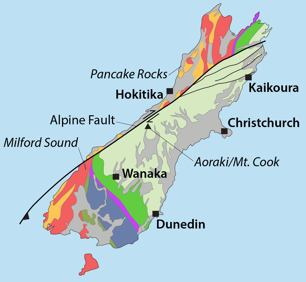
Map of New Zealand, showing accreted terranes in colors and cover assemblage in gray. (Compiled mostly from Graham, 2015)
North and South Island Bedrock The different colors on this map show New Zealand’s basement rock, named so because it forms the lowest known bedrock foundation of any given area. The basement tells stories of New Zealand’s deep past, from about 500-100 million years ago. Individual colors signify different terranes, accreted (added) one-by-one through plate motions to the edge of what was then the supercontinent Gondwana. They mostly consist of sedimentary and metamorphosed sedimentary rock, although the narrow belt of purple-colored Dun Mountain Ophiolite formed as oceanic lithosphere, and the red-colored areas consist of granitic igneous rock, some of which has been metamorphosed to gneiss.
Gray indicates the younger cover rock, formed after accretion of the terranes. Consisting of a wide range of sedimentary and volcanic rocks, as well as recently deposited sediment, it’s just as interesting and variable as the terranes. Because it includes volcanoes, it’s largely the cover that gives the North Island its distinctive flair. By contrast, the South Island consists largely of uplifted basement rock, much of which has been –and still is—glaciated. All those long deep lakes, such as Lakes Wanaka and Tekapo, were carved by glaciers and are now floored with their deposits of till.
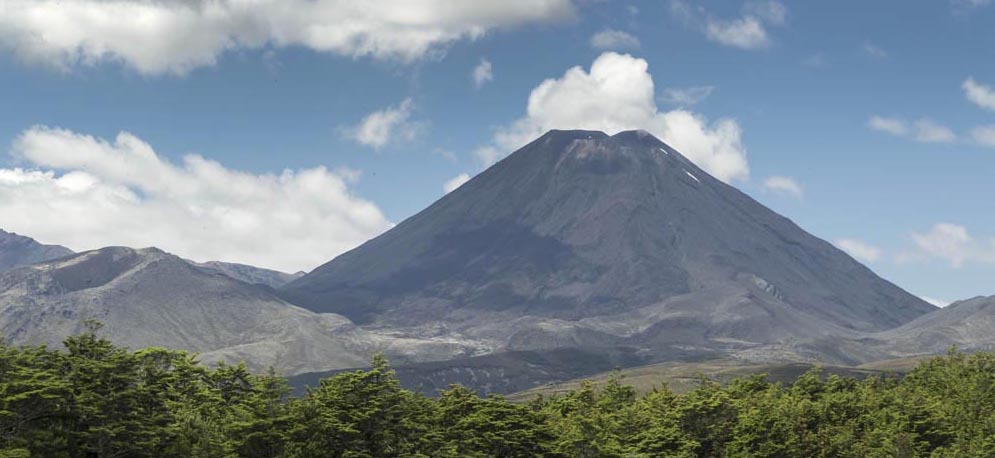
Mt. Ngauruhoe, a 7000 year-old andesite stratocone near Ruapehu on the North Island
Those differences exist largely because the North and South Islands occupy different plate tectonic settings. The North Island sits over a subduction zone, so it hosts an active volcanic arc, expressed as the Taupo Volcanic Zone. The North Island also hosts older volcanic arcs –and even an active volcanic field that roughly coincides with the city of Auckland! By contrast, the South Island is transected by the Alpine fault, which connects the subduction zone in the north with the one in the south as a transform fault. Much like the San Andreas fault in California, it and some related faults are responsible for a great deal of uplift—and formation of mountain ranges such as the Southern Alps and Kaikoura ranges –as well as uplift and subsidence along different parts of New Zealand’s coastline. You can see how far the Alpine fault has slipped by matching up the belts of accreted terranes on either side, particularly the Dun Mountain Ophiolite –some 460 km!
My trip: January 5-February 7
A quick note… you should be able to click on any of these images to see them as larger versions in another window.
… The greatest thing about my trip was that I was able to see and photograph most of these elements of New Zealand’s geology. (Please take a look at the many other images of New Zealand geology that I posted on my website) I started in Auckland, where I met up with a group of faculty and students from Centre College, a liberal arts school based in Danville, Kentucky. They were studying North Island volcanoes and graciously let me tag along. We spent most of our time near Auckland and in the Taupo Volcanic Zone. From there I went to Wellington and then on to the South Island, where I rented a car and traveled for another two weeks, mostly with my friend Megan.
Auckland area


Here’s a geologic map of the Auckland area, published by the New Zealand GNS (Geological and Nuclear Sciences). The reds and pinks are basalts of the Auckland Volcanic field; the browns are Miocene sedimentary rocks that contain an abundance of volcanic particles, and the blue marks the Waipapa Composite Terrane, which forms the local basement.
The Auckland Volcanic Field consists of more than 50 volcanoes, many of which are small cinder cones that show evidence of explosions related to water-magma interactions. The first eruption occurred 250,000 years ago and the most recent, at Rangitoto, only 600 years ago. Rangitoto is the large red circular island in the northeast corner of the map. It’s a small shield volcano, capped by a cinder cone, which makes for a lovely boat ride and hike! Rangitoto is the only volcano in the field that shows evidence for repeated eruptions. Because of the recency of the volcanism –and the fact that it encompasses Auckland, the GNS is actively monitoring the field and making preparations in the event of an eruption.
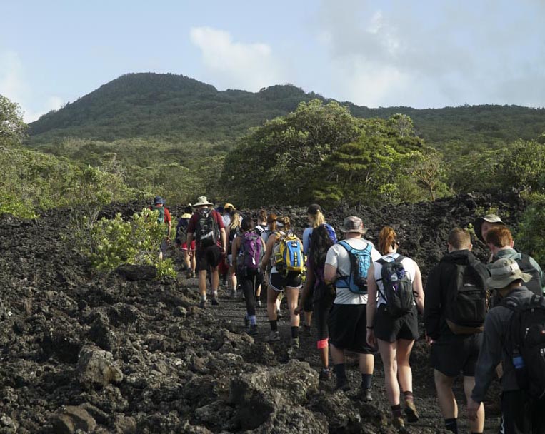
Our group hiking up Rangitoto
Taupo Volcanic Zone
The Taupo Volcanic Zone (TVZ), which first started erupting about 2 million years ago, occupies a rift zone, marked by numerous, recently active normal faults. The rift is superimposed on the modern volcanic arc produced by subduction of the Pacific beneath the Australian plate. The TVZ is dominated by andesitic volcanism towards the northeast and southwest ends of the zone and rhyolitic volcanism in between, all of which is active or recently active. We visited localities throughout the zone.

Active crater in White Island. Crater Walls are mostly pyroclastic deposits.
White Island, in the photo above, is an active stratovolcano that rises right out of the Bay of Plenty. The volcano marks the northern end of the zone. Its breached crater hosts a gigantic rock avalanche deposit, crater lake, sites of active sulfur mineralization, crater walls of pyroclastic deposits, and steam, steam, steam!
Meads Wall, an andesite dike intruding lavas on Mt. Ruapehu, New Zealand (180114-18)
Ruapehu, another active stratovolcano, marks the southern end of the zone. We spent the last 8 days of the course in and around that area, including hiking the well-known Tongariro Crossing and climbing to Ruapehu’s crater lake at its summit. I, of course, sprained my ankle just before the Tongariro hike and missed the summit hike because I was on a bus to Wellington. Those are altogether different stories! One place I especially like is Meads Wall, shown in the adjacent photo. It’s a large andesite dike that cuts through older andesite lava flows.
The rhyolitic volcanism that dominates the central part of the TVZ gives a more subtle expression to the landscape than the prominent andesitic stratovolcanoes –which is largely because the rhyolitic eruptions were so gigantic as to form calderas and blanket the entire area with ash flow tuff and air fall. The ash flow tuff shown below was deposited by the Taupo eruption only 1800 years ago. It erupted more than 100 km3 of material. An earlier eruption from the same volcano, called the Oruanui eruption, put out an estimated 1000km3 of material and formed the caldera that holds Lake Taupo. Altogether, eruptions in the TVZ have erupted more than 10,000 km3 of magma since they started about 1.6 million years ago. Cole and Spinks (2009) list seven calderas within the zone.

Ash flow tuff. Bluffs near Turangi; close-up showing pumice fragments; Joe Workman, our leader, leaning against a wall of tuff near Taupo.
The thermal springs in and around the town of Rotorua provide a great expression of the current activity. One of my favorite spots was the Waiotapu thermal area, some 30 km southeast of Rotorua. Among other things, it hosts numerous explosion craters filled with hot springs. Below is a photo of the colorful “Champagne Pool”, which gets its name from the CO2 bubbles that rise to the surface. The colors result from a variety of things, including yellows and oranges from the sulfide minerals orpiment (arsenic) and stibnite (antimony), and white from sinter (silica) deposition.

Hydrothermal spring and deposits, Waiotapu, New Zealand. The white color is sinter (silica) and orange and yellows from antimony and arsenic precipitation.
Wellington area
In Wellington, my friends Rob and Sue took me to Red Rocks Scientific Preserve, some beautiful coastal exposures of the accreted Torlesse Composite Terrane. While most of the Torlesse around Wellington consists of Jurassic and Cretaceous submarine fan deposited sandstone, these rocks consist of chert, argillite, and basalt of probable Triassic age.

Distracting Fur Seal on the Red Rocks
And Wellington sits right next to the Wellington fault—one of the several fault zones that link the Alpine fault to the subduction zone. The Wellington fault is the closest of many faults that pose major earthquake hazards for New Zealand’s capitol city. According to the GNS, it last ruptured some 300-500 years ago –and has an estimated recurrence interval of 500-1000 years. The Wairarapa fault, only 20 km southeast of Wellington, broke in 1855 to unleash an earthquake estimated to be M8.2-8.3. Even the 2016 Kaikoura Earthquake, which occurred on the South Island, caused more than $500 million in damage to Wellington.
Ferry from Wellington to Picton (South Island)
I had a beautiful day for this beautiful ride, three and a half hours from Wellington across Cook Strait to Picton, a small town tucked away inside the countless inlets and bays of the South Island’s north coast. The intricate coastal landscape results from gradual subsidence of the land and invasion of the sea up pre-existing river valleys, many of which follow fault zones. Two of these faults are sketched in on the map.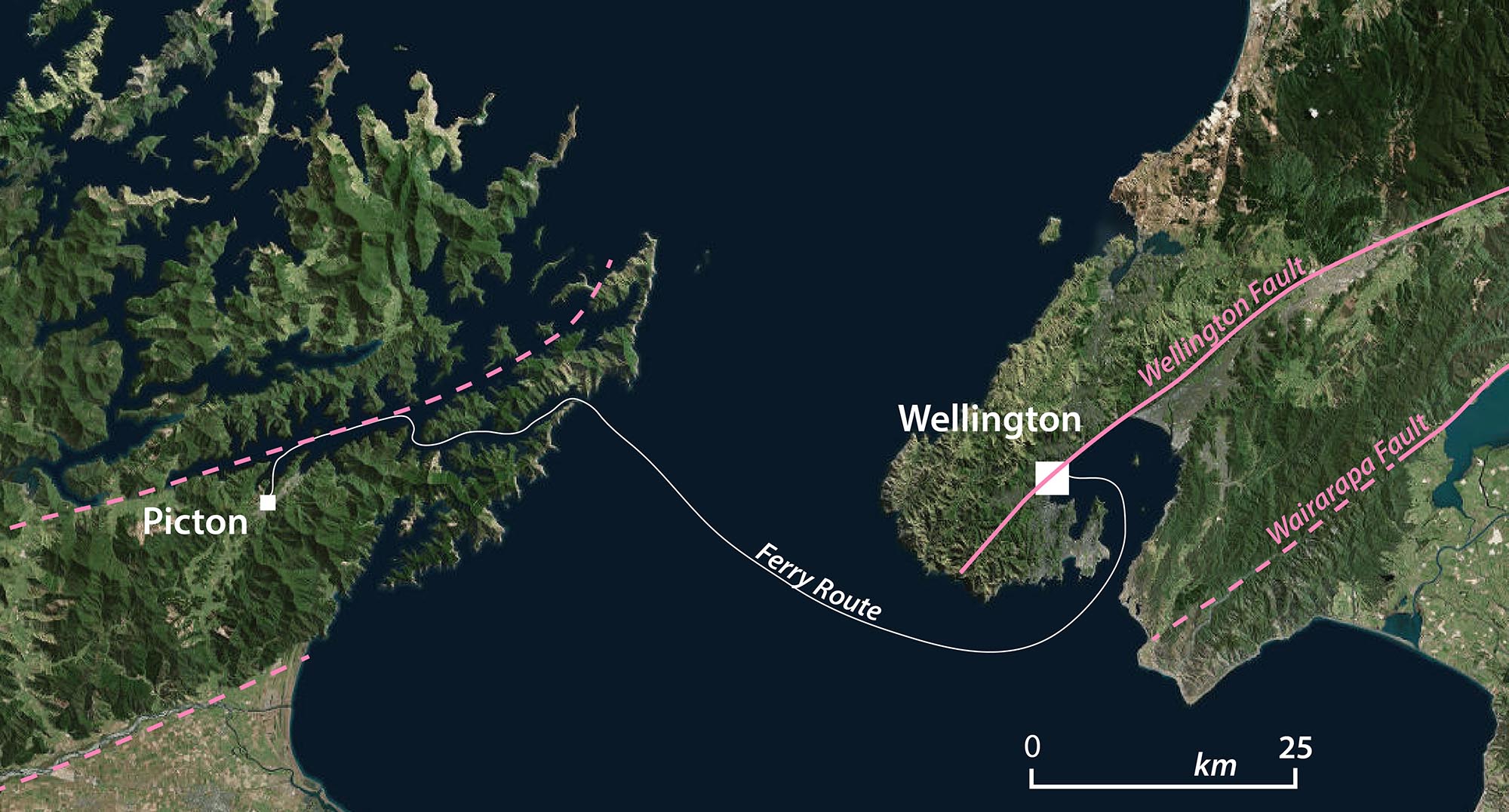
And here’s a map of the South Island!
Kaikoura area
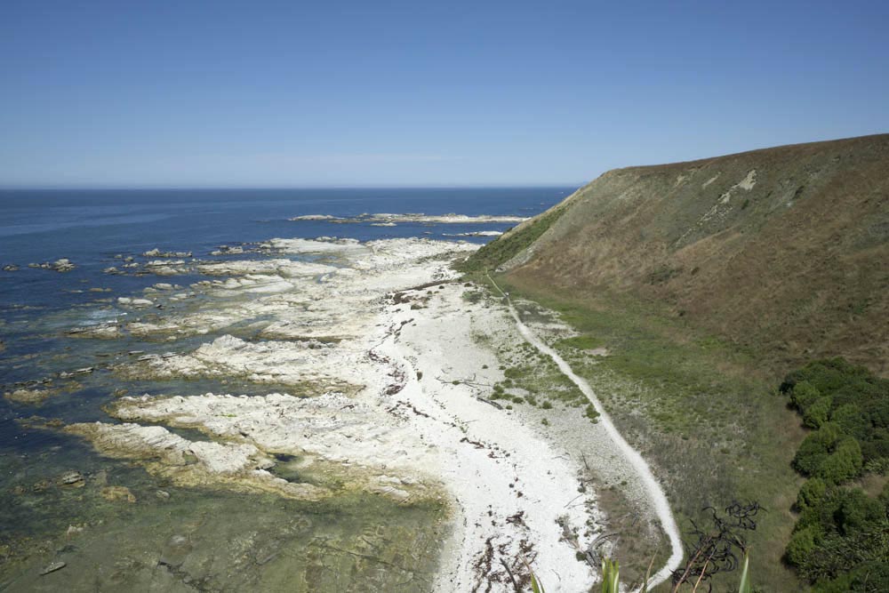
wave-cut bench, stranded beaches, and uplifted terrace at Kaikoura
Unlike the subsidence of the northern coast, the story around Kaikoura is one of coastal uplift. In fact, the 2016 Kaikoura Earthquake caused more than 5 meters of uplift in places. 5 meters! Near Kaikoura itself, that value was more like 1 meter, but still, you could see its effects. There’s an easy trail that crosses the Kaikoura Peninsula and returns via the beach. You can see the wave-cut bench, now largely above the intertidal zone, and stranded beach ridges. Then there’s the flat top of the peninsula. Formerly a wave-cut bench, it’s been uplifted by multiple earthquakes through thousands of years!
And the earthquake spawned countless landslides, many of which affected the coastal highway. My favorite slide was a few miles west of the highway up the Clarence Valley, shown below. I still haven’t determined if this is the same slide, but three cows got stranded on a slide block to become the subject of my now-favorite children’s book: “Moo and Moo and the Little Calf Too” by Millton and Hinde… it’s wonderful! Together, the landslides and ground ruptures during the earthquake closed the highway for over a year. It reopened in December, 2017—and they’re still working on it.
Christchurch

Waimakariri River and alluvial plain near Christchurch
Christchurch is really easy to find on a map because it sits on the north side of the Banks Peninsula, an almost circular protrusion into the Pacific. The peninsula marks a complex of shield volcanoes, active some 11-8 million years ago but now deeply eroded. Christchurch itself is pretty flat. It sits on the alluvial plain of the Waimakariri River, which rises in the southern Alps and enters the sea just north of the city. I picked my friend Megan up at their lovely airport and we went for a long beach walk –very few other people—just miles of sand and clouds and water and dunes…
Southern Alps (Mt. Cook –Aoraki)
Rocks are cool, but glaciers… wow! The glaciers, their erosional features, and their deposits are absolutely spectacular in this area! And besides, the bedrock around Mt. Cook/Aoraki is mostly this poorly bedded greywacke of the Torlesse Composite Terrane –so my camera saw mostly ice and landscape carved from the rock.

Mt. Cook Village, which has a couple hotels and a youth hostel, sits on a small alluvial fan on the edge of the glacial outwash plain. The mountains positively soar overhead. Megan and I hiked up to the Mueller Hut, situated on the long high ridge just south of the village. Everywhere, we saw the effects of ice. We could even hear the erosion, as rock and snow avalanches broke loose frequently on the glaciers across the valley. No wonder the area hosts incredible U-shaped, glacially eroded valleys and no wonder that the upper reaches of the valleys form bowl-shaped cirques, many of which are still occupied by glaciers. No wonder that steep headwalls rise behind the cirques. No wonder the peaks and ridges are so jagged. At the same time, it fills you with wonder!
For me, the most instructive view was up the Hooker Valley towards Mt. Cook. There, you see the lake below the Hooker Glacier, dammed in by one of the glacier’s moraines –and in the foreground, you see another lake in another valley dammed in the same way. Turning your gaze downstream, you can see the magnificent outwash plain, merging with the outwash plain of the Tasman Glacier –and then emptying into long Lake Pukaki—which fills a glacial valley that’s dammed by a moraine!
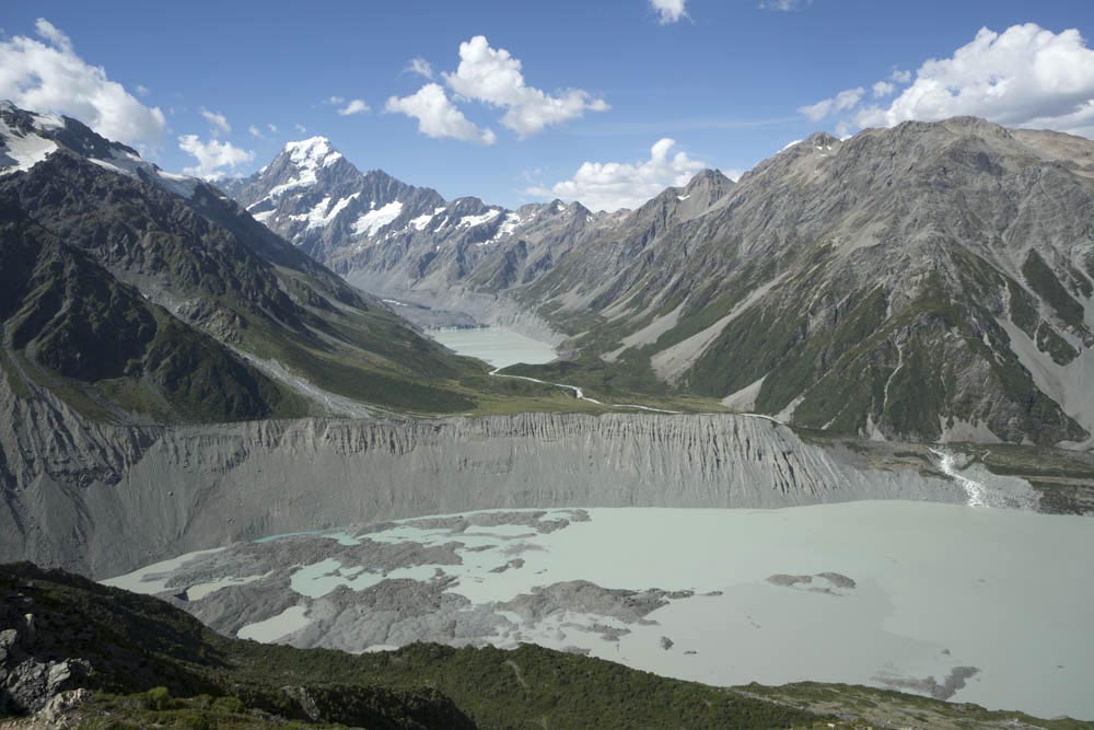
Moraines of till and moraine-dammed lakes.Mt. Cook -Aoraki- in background
Milford Sound

 As if Mt. Cook/Aoraki wasn’t enough, the experience of seeing the glacial fjord of Milford Sound kind of blew our minds. I was anxious beforehand because a storm was blowing in and I thought we’d get all wet and cold and be tossing about on the boat, but it turned out that the rain, sprouting thousands of waterfalls, made the place magical—and we were very comfortable on the boat. The rocks were pretty amazing too. Described by the GNS as orthogneisses, they originated as part of the Median Batholith during the Paleozoic but were metamorphosed and deformed during later mountain-building events, natural results of terrane accretion.
 Fjords are narrow arms of the ocean that cut into the land. They have steep steep walls that rise 1000’s of feet on either side and drop steeply to great depths below water line. Fjords occupy former glacial valleys, deepened and steepened by the ice as it flowed down the valley towards the sea. When sea levels rose after the ice retreated, the sea invaded the former valleys. During rainy periods, the water, with little area to collect, runs off almost instantly as thousands of waterfalls. The next day, they’re mostly gone.
Bombing up the West Coast
We didn’t give enough time to the west coast –driving all the way from Wanaka to Hokitika in one day. It turns out that the storm we encountered at Milford Sound was much worse to the north, temporarily blocking the coast highway with fallen trees and landslides. And it washed out the access road to the Fox Glacier and the trail to Franz Josef Glacier, two glaciers that flow out of the Southern Alps to reach low, accessible elevations. I got to see the Fox Glacier 4 years ago –and this year, we did get a nice view of the braided river below the Franz Josef Glacier.
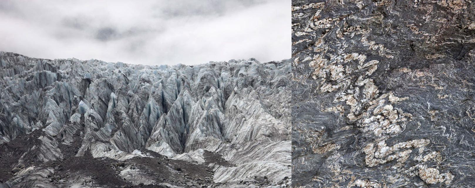
Fox Glacier and metamorphosed sedimentary rock–from my trip in 2014.
One of the things I remember about the Fox Glacier was the awesome bedrock! There, the greywacke of the Torlesse Terrane is metamorphosed to schist. This metamorphism seems to concentrate along the Alpine fault and die out away from it. The ridge we hiked to near Mt. Cook/Aoraki, for example, lies only 25 km to the south and consists of unmetamorphosed rock. These differences show how the Alpine fault is causing uplift of the range, the highest rates being right along the fault. We missed seeing the exposure of the fault at Gaunt Creek, just north of Franz Josef. Bummer.
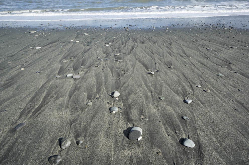
Beach near Hokitika
Hokitika was great. Turns out that it’s the prime place for New Zealand jade. The jade is nephrite, which is a microcrystalline variety of amphibole of the actinolite-tremolite series: the closer its chemistry to the iron-rich actinolite, the greener its color; the closer it’s to the magnesium-rich tremolite, the whiter its color. The nephrite forms in the southern Alps as a replacement mineral in lenses of serpentinite, enclosed by schist of the Torlesse Terrane. Most people find it as boulders and cobbles on the local beaches or rivers that drain this part of the southern Alps. We went looking of course –and came back with a lot of pretty rocks—but I’m skeptical we found any jade.
We also visited the Pancake Rocks near Punakaiki—made of 30 million year old limestone, which is part of New Zealand’s post-accretion cover sequence. The rocks have eroded along vertical fracture surfaces and show this really cool enhanced bedding, likely the result of dissolution along original bedding planes during compaction of the sediment. And it’s a beautiful headland, with sea stacks, a sea cave, blowhole, and a fabulous rock-fall deposit. And there are a zillion tourists—one guy practically pushed Megan over the edge to take his picture! Sigh…
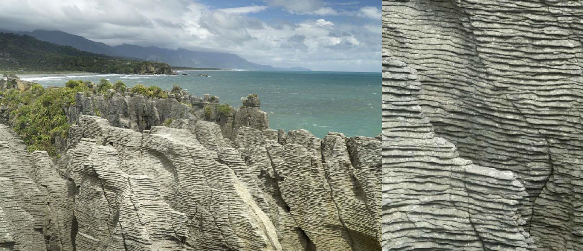
Pancake Rocks near Punakaiki. Photo on right shows close up of enhanced bedding.
The highway across Arthur’s Pass back to Christchurch goes through some awesome scenery. In my mind, the best part was the eastward descent along the Waimakariri River—which at higher elevations makes beautiful braided channels in an outwash-choked floodplain. And the river terraces along the Broken River, each higher level marking an older floodplain were positively amazing. But we had a plane to catch.

Braided channels and gravel bars on Waimakariri River.
To see more geological images, of here or New Zealand, please check out my website!
A few useful references:
Taupo Volcanic Zone: Cole, J.W. and Spinks, K.D., 2009, Caldera volcanism and rift structure in the Taupo Volcanic Zone, New Zealand, in Murphy, Kepple, and Hynes, eds., Ancient Orogens and Modern Analogues, Geological Society of London Special Publication 327.
Wellington fault: https://www.gns.cri.nz/Home/Learning/Science-Topics/Earthquakes/Major-Faults-in-New-Zealand/Wellington-Fault
General NZ geology: Graham, Ian J. editor, 2015, A Continent on the Move, New Zealand Geoscience Revealed 2ed., Geoscience Society of New Zealand, 397p.
And of course: Millton, J., and Hinde, D. (illustrator), 2017, Moo and Moo and the Little Calf Too. Allen and Unwin, Auckland.

New Zealand is a place where I’ve always wanted to visit but will never get the chance: I’m too old now! The account here of your visit is fascinating … at least in terms of geology. And it makes me want to ask: of all the places in the world that you’ve explored, what are your top 3 areas or regions for geological diversity?
LikeLiked by 1 person
Hi Wes! You’re certainly not too old for New Zealand! –and I’d put it in my top 3 for diversity, although I can’t say I’ve really traveled so many places. I’d also put Death Valley in there! And the other? Maybe somebody else can fill that in!
LikeLiked by 1 person
Absolutely fascinating! Thank you for sharing your geologic adventure. Another one for my bucket list.
LikeLiked by 2 people
I’ve been down there four times and it is magnificent. The GNS maps are a treasure.
LikeLiked by 1 person
Yes… they really are –It’s especially nice that you can download them for free!
LikeLiked by 1 person
Just returned from NZ. Thanks for this very informative post. I am a retired soil scientist and when I am “in the field” I love having a good geologist handy to explain what I’m looking at. We saw most of what you describe here.
LikeLiked by 2 people
Thanks for the nice comment!
LikeLiked by 1 person
Planning a trip to NZ for Feb 2019…It will be my first time down under, and I was looking for travel tips / photographs *by* a geologist, *for* other geoscientists! So Thank You, just found the perfect start to our planned geo-tour.
LikeLiked by 1 person
Thank you for the nice words! –and sorry it’s taken me so long to get back to you!
LikeLiked by 1 person