I’ve long been drawn to Death Valley. As a geologist, I can’t think of a better place to witness the incredible geologic history that shaped western North America –and as a photographer, I can’t think of a better place to capture images of what’s a mind-boggling array of geologic features.
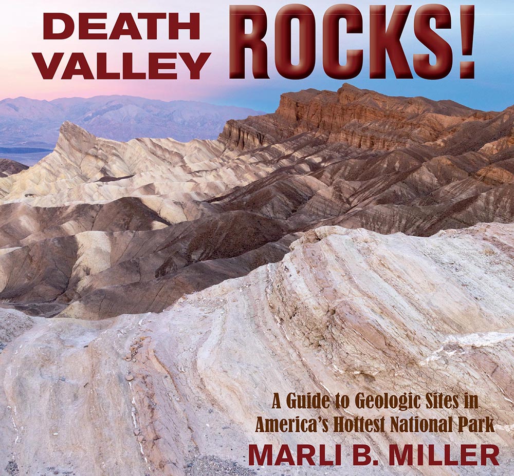
To that end, I recently completed a book called Death Valley Rocks! A guide to geologic sites in America’s hottest national park. It’s being published by Mountain Press and should be out in early July. The book covers 40 geologically amazing sites in the national park as well as the adjacent Amargosa Valley and will be full of color photos and maps –and (of course) many of my photos didn’t make the cut. Here are twelve of those outtakes, selected to present a general picture of Death Valley’s geology. You can click on any image to see it at a larger size.
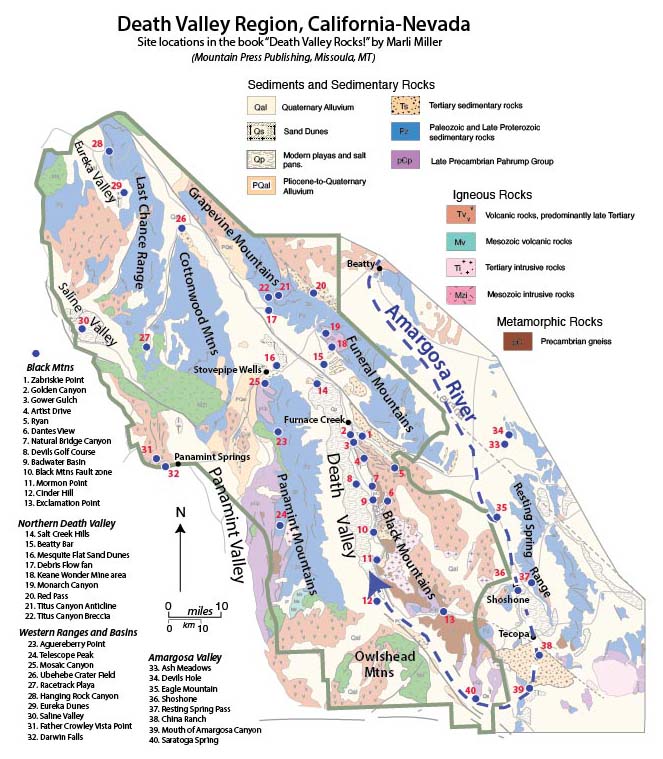
The first photos reflect Death Valley’s modern setting, an actively evolving basin in the southwestern part of the Basin and Range Province. The valley is the terminus of the Amargosa River, shown as the heavy dashed blue line resembling a giant fishhook in the map. The river starts just north of Beatty, Nevada, and flows southward about a 100 miles through the towns of Shoshone and Tecopa before turning northward to empty into Death Valley. Without an outlet, all the water that reaches the floor of Death Valley stays there until it evaporates. As it evaporates, the water precipitates salt, producing a magnificent salt pan that is broken by myriad polygonal shrinkage cracks.
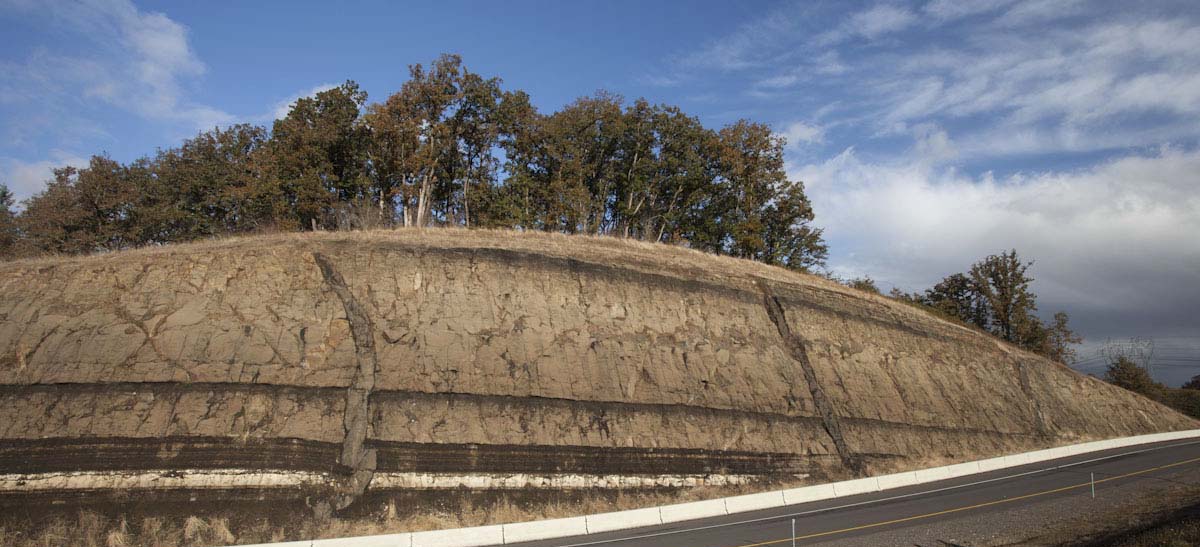
You don’t see many rocks where I live in western Oregon. Lush forests or savannah-like areas dotted with Oak, yes, but the bedrock mostly lies beneath the vegetation and a thick mantle of soil. Just south of town though, the highway cuts through a hillside to expose rock that reminds us of our geologic setting –and taken in context, points to Earth’s incomprehensibly long history.
I’m standing in a soft rain at the foot of the roadcut, looking upwards at some 50 feet of strata. The rocks are sedimentary, having been deposited in lakes and rivers, but there’s also a thin layer of light-gray ash near the top of the cut and a much thicker one near the bottom –and slashing vertically through everything are two narrow gray, almost black, bodies of igneous rock. Called dikes, they worked their way upwards as molten rock along cracks in the older sedimentary rock before cooling and crystallizing where they are now.
Highway Roadcut near Eugene, Oregon
Evidence of ancient volcanic activity abounds: ash, dikes, even the sedimentary rocks are made mostly of volcanic particles. And on clear days, I can walk to the south side of the roadcut and look eastward to forested ridges of the Western Cascades that give way in some 50 miles to the snow-capped peaks of the High Cascades. They’re all volcanic. The High Cascades volcanoes are young and active whereas those of the western Cascades are long extinct and deeply eroded. Combined, the two parts of this range formed over a period of about 40 million years and produced miles and miles of lavas, ash and debris flows, and volcanic-rich sedimentary rocks.
Trying to imagine this 40 million-year history is like watching the stars, filling me with wonder and leaving me humbled, subdued, and exhilarated, all at the same time. And by geologic standards, 40 million years isn’t extremely long. Death Valley, California, one of my favorite haunts, showcases some 30,000’ of sedimentary rock that was deposited over a period of 400 million years, between about 700 and 300 million years ago –and beneath them lies rock that records conditions on Earth’s surface over a billion years ago. Anyone can see these rocks, touch them, and imagine the incomprehensible.
Paleozoic strata in Death Valley
When I was in college, I encountered a textbook passage that helped me visualize geologic time. The author, Don Eicher of the University of Colorado, imagined Earth’s entire 4.54 billion year history compressed into a single year. He pointed out that, in this calendar, Earth’s first organisms would’ve lived sometime in late March, the first creatures that produced shelly fossils appeared November 17, and the first land plants around November 23. He included many noteworthy events, but they didn’t include the Cascade Range. By my calculations, the 40 million years of Cascade volcanic activity existed for about the last three days of this calendar year. The first humans? They appeared about 35 minutes before midnight.
It boggles the mind to think about how much humans have done in those 35 minutes, so much so that we’re considering naming a geologic period of time after ourselves: the Anthropocene. It’s likely that we’d designate it an “epoch” so it would naturally come after our present epoch, the Holocene, which followed the Pleistocene (Ice Age), which followed the Pliocene, and so on. Of course, any formal designation would require people to agree on exactly when it began and for that there is little consensus because humans caused major changes on Earth at different places during different times. The one time most researchers agree affected everywhere at once was the widespread atomic weapons testing in the late 1940s and 1950s, which spread radionuclides across the planet and are now an identifiable part of the sedimentary record.
Folded mylonitic gneiss, Death Valley, California
Without question, humans are an indomitable geologic force, especially since the early 1950’s. It’s no wonder many researchers call that time “The Great Acceleration”, when our technology and energy use increased exponentially. And less than 40 years later during the 1990s, we recognized that our activities move more material each year than any other natural force such as rivers or landslides or glaciers. Since then, our “bioturbation” has only increased. We have colonized every habitable nook and cranny on this planet and are precipitating environmental catastrophes we’re only beginning to comprehend.
But to call this human time period a geologic epoch seems to imply a certain longevity to both the period and to its trademark origin: Homo sapiens –and since 1950, the earth has aged barely a half second in its year-long calendar. I wonder how much longer we can last. To me, the concept of the Anthropocene as an epoch seems contingent on us surviving our environmental crises and continuing for thousands of years. After all, the Holocene Epoch, which it would replace, lasted for 10,000 years, and all the epochs before lasted millions. Instead of a new epoch, we may instead be in a transitional period from the Holocene to something that postdates Homo sapiens. If that’s the case, then we’re witnessing more of dramatic event: mass extinctions and environmental changes that will herald an altogether different ecosystem.
I reach down at my feet and untangle a wet plastic bag from some rocks that have fallen from the roadcut. So different, yet both pieces of sediment just the same. Both may find their way into the rock record. I wonder how our part of the record will appear long after our time has passed. I imagine we’ll be a readily identifiable layer, thick in some places and thin in others, and everywhere representing the same moment in time. It won’t be an epoch, but a fleeting second or two in Earth’s year of ages.
inside the crater of Mt. St. Helens (click on images to see them at full size)
Terminus of Crater Glacier, Mt. St. Helens, Washington
There’s a glacier in the crater of Mt. St. Helens—and unlike most other glaciers, it’s growing. Shaded by soaring crater walls and continually replenished by snow avalanches and rockfalls, it oozes forward more than 100 feet per year. At the sound of a loud crack, I look up at its steep front to see a bunch of rocks breaking free of the ice and tumbling downwards to rejoin their compatriots at the bottom. Soon, the ice will advance over them and they’ll be a part of the glacier again.
I’ve long been attracted to these landscapes, practically devoid of organic life but alive just the same. They evoke a sense of timelessness, a connection to Earth’s past, long before mammals and reptiles, let alone humans, colonized its surface. Besides this glacier, near-continuous rock fall and rising dust plumes, there’s a 1000’ tall lava dome that still puts out steam. Younger than many teenagers, the dome formed as sticky silica-rich lava extruded from a vent in the crater floor. It rose to within 800 feet of the highest part of the rim over a period of 5 years, from 2004-2008. It now towers over an older dome, which grew from 1980 until 1986, scarcely middle-aged by human standards.
Crater domes and fumarole emissions. The dark ledge across the bottom of the photo marks the terminus of Crater Glacier.
My group is taking its lunch break. One person’s off shooting photos, a few are talking quietly, another’s inspecting some of the pumice and broken rocks that blanket this part of the crater. Our guides are conferring over our route. I feel lucky to be here, having been invited a few months ago to accompany the group to talk about the geology. The Mt. St. Helens Institute, the non-profit that organized the trip, does so under a special use permit from the Gifford Pinchot National Forest.
Looking northward to Spirit Lake and Johnston Ridge, I see a landscape of somber browns, yellows, and grays, decorated with greens. Most of those colors come from rock, either ancient bedrock or eruptive products from the big eruption in 1980. The greens though come from vegetation that is rapidly covering the lower elevations. On the way here, we walked over ashy fields spotted with prairie lupine, paintbrush and a host of other wildflowers I couldn’t identify, small stands of juvenile Douglas Fir and through the occasional jungle of alder.
View northward from the crater entrance to Spirit Lake and the eastern edge of Johnston Ridge.
Almost nothing in my view was spared the effects of the 1980 eruption. At 8:32am, May 18, a magnitude 5.1 earthquake caused the bulging north side of the mountain to fail as a gigantic avalanche, releasing pressure on the magma within the volcano, which naturally expanded northwards at supersonic speeds. Entire forests blew over in the scalding hot gas. 10 miles from the crater and forty years later, you can still see many of these trees lying down in formation, just like toothpicks. The failed north side of the mountain, all .67 cubic miles of it, ranks as the world’s largest debris avalanche in recorded history. I can see its path, marked by giant piles of rock called hummocks. Even here in the crater are deposits of the debris avalanche, forming towers of conical pointed hills more than 100 feet high.
Hikers and landslide hummocks in the crater of Mt. St. Helens, Washington.
I stoop down to look at a small plant. It’s all by itself, growing between loose, rounded pieces of pumice and undoubtedly rooted in more of the same. An early colonizer. If the crater floor were to remain undisturbed, more vegetation would creep in and eventually, this place would become lightly forested like other places nearby at this elevation. Of course, that’s unlikely here, with an advancing glacier and all the rocks falling from the rim.
Or more eruptions! Mt. St. Helens is, without question, the most active volcano in the Cascade Range, with more than a dozen smaller eruptions since the big one on May 18. And long before 1980 there were hundreds. The US Geological Survey closely monitors Mt. St. Helens’s ongoing activity as well as its geologic past to understand the volcano’s behavior through time. They define its history in terms of four distinct eruptive “Stages” that stretch back some 275,000 years. The most recent of these, the Spirit Lake Stage, started about 3900 years ago and is further divided into six eruptive “Periods”, each marked by multiple eruptions and separated by times of dormancy. One of these eruptions, between 3500-3300 years ago during the Smith Creek Period, dwarfed the 1980 eruption. And in the early 1480s, two eruptions of comparable size to the one in 1980 occurred just two years apart.
Shading the sun from my eyes, I look southward to the volcano’s rim, and I can see a whitish layer produced by these two eruptions. It’s called the “W Tephra”. More than 250 feet of rock now sits above it –all formed after 1480. And there used to be 1300 feet of rock above that, until it was blasted off in 1980—which means that in 500 years, Mt. St. Helens grew more than a quarter mile in height. Just before its cataclysmic eruption, its summit stood 9,677 feet above sea level.
Dacite domes and Crater Glacier in crater of Mt. St. Helens, Washington. The W Tephra forms the light-colored band at the end of the arrow.
It’s the myriad smaller eruptions that cause a volcano to grow, and in the case of Mt. St. Helens, they mostly produce lava domes instead of lava flows. As a college student, I had the hardest time visualizing a lava dome because the photographs I saw just looked like gigantic piles of broken rock. But that’s basically what they are, gigantic, dome-shaped, piles of rock. Imagine lava that is so viscous it can hardly flow, oozing out of a volcanic vent, and pushing aside or piling on top of earlier extruded lava, and cooling and breaking up in the process. By its very nature, silica-rich lava like the dacite of Mt. St. Helens is highly viscous. Silica molecules bond with each other to form interconnected networks, so the more silica in a lava, the more viscous it tends to be. Lower silica lavas like andesites contain fewer of those networks so they’re more likely to produce lava flows. Basaltic lavas contain even less silica and flow even easier.
Feeling a gentle breeze, I close my eyes and imagine this place sometime in the future. Two hundred years? Five hundred years? I picture the crater walls, slightly lower now, having steadily eroded through time, their debris gradually filling the crater. A couple large landslides have removed large fractions of one of the walls and piled their debris up against today’s modern domes. During this time, the mountain was largely dormant, but now a pulse of basaltic magma is working its way towards the surface, intruding the gray dacite domes along fracture surfaces as black basaltic dikes. Some of these dikes break through the top of the domes and spill out as basaltic lava flows, which flow a short way down and out of the crater. Mt. St. Helens awakens again, but this time, the lava is basalt so it awakens quietly.
I remind myself that this volcano hasn’t produced much basalt during its 275,000-year history. It doesn’t tend to “awaken quietly”, but more like some grumpy person who you’ve roused with a splash of ice water. Besides the numerous domes, its products typically depict violence: deposits of fallen ash or pumice, or pyroclastic flows, which consist of fast-moving ash, pumice and rock fragments mixed with hot gases. The only basalt lavas from Mt. St. Helens erupted during the end of the Castle Creek Period, which stretched from about 2500 to 1900 years ago. Ape Cave, the lava tube on the volcano’s south side, formed in these lavas, as did the steep rocky slopes we climbed on our hike into the crater. And there, low on the east crater wall, I can see the drama: black Castle Creek dikes slicing through light-colored rock of an older dacite dome. They’re overlain by dark-colored Castle Creek lava flows likely fed by the dikes below, just like my daydream.
Basaltic dikes of the Castle Creek Period cut an older dacite dome. Pyroclastic flow deposits form the layered materials near the bottom of the photo in shadow.
As we start our descent, I reflect on the ongoing Modern eruptive period. Before the first earthquakes on March 16, nearly everyone in the Pacific Northwest viewed Mt. St. Helens as a perfectly symmetrical and docile ice cream cone of a mountain. My college friend Michael longed to return home to Portland for long enough to climb it, partly because it offered such a wonderful glissade after summiting. Then less than two weeks after those first earthquakes, the first steam eruptions began. Then more earthquakes. Bulging of the northern edifice. Steam. Earthquakes. May 18.
We’ve learned so much since then! We’ve watched the Modern Period unfold with our own eyes as well as with a vast array of ever-evolving instruments. We can see the rich details of the volcano’s behavior to the point that researchers divide the last 40 years into two subperiods, defined by the formation of each lava dome. We’ve watched Crater Glacier evolve from a snowfield to a full-on glacier that itself has experienced major changes in its shape and behavior. We’ve watched the crater rim erode. We’ve watched vegetation recolonize a landscape that was suddenly rendered devoid of nearly all organic life.
Loowit Falls and debris avalanche deposits.
Our group stops for a quick break at Forsyth Spring to absorb the flourishing willows, alders, and sounds of running water. I contemplate the earlier phases of Mt. St. Helens, reaching back to its origin as a series of lava domes 275,000 years ago. Those phases must have been as interesting and diverse as today, but we can experience them only through whatever preserved evidence we can find in the volcano’s deposits. We can’t taste the water or feel the freshness of new growth. Still, we can imagine it.
For this reason, I don’t think of today’s Mt. St. Helens as being “reborn” as it’s so often described. Sure, the vegetation is returning, but I can’t help but see it as incidental to the overall story of a volcano that’s always in transition. The 1980 eruption wasn’t an end point or a beginning –just an event that happened during a long eventful history. We’re experiencing just another moment, another transition, in this volcano’s cycle of life.
While Iceland hosts an amazing variety of awesome landscapes, what stands out to me most are its incredible exposures of the Mid-Atlantic ridge. To the north and south, the ridge lies beneath some 2500m of water, forming a rift that separates the North American plate from the Eurasian plate. The rift spreads apart at a rate of some 2.5 cm/year, forming new oceanic lithosphere in the process. But in Iceland, you can actually walk around in it!
Please click on any of the images below to see them enlarged.
Geologic map of Iceland as compiled from references listed below.
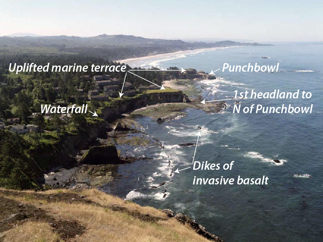
You could teach a geology course at Devil’s Punchbowl, a state park just north of Newport, Oregon. Along this half-mile stretch of beach and rocky tidepools, you see tilted sedimentary rocks, normal faults, an angular unconformity beneath an uplifted marine terrace, invasive lava flows, and of course amazing erosional features typical of Oregon’s spectacular coastline. And every one of these features tells a story. You can click on any of the images below to see them at a larger size.
View southward from Cape Foulweather to the Devil’s Punchbowl.
The rocks. They’re mostly shallow marine sandstones of the Astoria Formation, deposited in the early part of the Miocene, between about 16.5 to 22 million years ago. The rocks are tilted so you can walk horizontally into younger ones, which tend to be finer grained and more thinly bedded than the rocks below. This change in grain size suggests a gradual deepening of the water level through time. In many places, you can find small deposits of broken clam shells, likely stirred up and scattered during storms –and on the southern edge of the first headland north of the Punchbowl, you can find some spectacular soft-sediment deformation, probably brought on by submarine slumping. Later rock alteration from circulating hot groundwater caused iron sulfide minerals to crystallize within some of the sandstone. Read more…
New Zealand’s landscape can make just about anybody appreciate geology. Its glaciated peaks, its coastline –that ranges from ragged cliffs to sandy beaches to glacial fjords– its active volcanoes… they all work together to shout “Earth Science!” With that in mind, here’s some basics of New Zealand’s amazing geology, followed by some geological highlights of my trip of January and early February, 2018.
Map of New Zealand, showing accreted terranes in colors and cover assemblage in gray. (Compiled mostly from Graham, 2015)
North and South Island Bedrock The different colors on this map show New Zealand’s basement rock, named so because it forms the lowest known bedrock foundation of any given area. The basement tells stories of New Zealand’s deep past, from about 500-100 million years ago. Individual colors signify different terranes, accreted (added) one-by-one through plate motions to the edge of what was then the supercontinent Gondwana. They mostly consist of sedimentary and metamorphosed sedimentary rock, although the narrow belt of purple-colored Dun Mountain Ophiolite formed as oceanic lithosphere, and the red-colored areas consist of granitic igneous rock, some of which has been metamorphosed to gneiss.
Gray indicates the younger cover rock, formed after accretion of the terranes. Consisting of a wide range of sedimentary and volcanic rocks, as well as recently deposited sediment, it’s just as interesting and variable as the terranes. Because it includes volcanoes, it’s largely the cover that gives the North Island its distinctive flair. By contrast, the South Island consists largely of uplifted basement rock, much of which has been –and still is—glaciated. All those long deep lakes, such as Lakes Wanaka and Tekapo, were carved by glaciers and are now floored with their deposits of till.
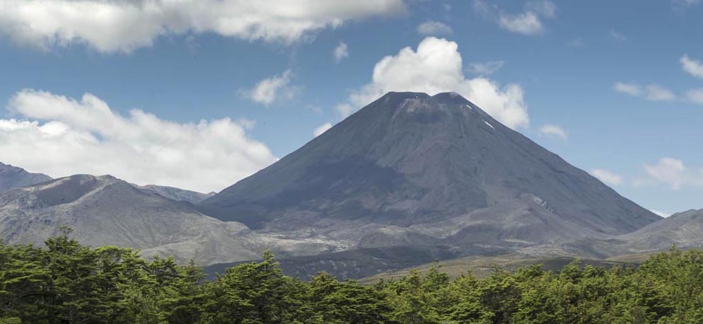
Mt. Ngauruhoe, a 7000 year-old andesite stratocone near Ruapehu on the North Island
Those differences exist largely because the North and South Islands occupy different plate tectonic settings. The North Island sits over a subduction zone, so it hosts an active Read more…
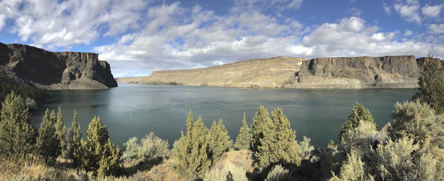
If I were a water skier, I’d go to Lake Billy Chinook at Cove Palisades where I could ski and see amazing geology at the same time. On the other hand, I’d probably keep crashing because the geology is so dramatic! Maybe a canoe would be better.
View across the Crooked River Arm of Lake Billy Chinook to some of the 1.2 million year old canyon-filling basalt (right) and Deschutes Fm (left). The cliff on the far left of the photo is also part of the 1.2 million year basalt.
The lake itself fills canyons of the Crooked, Deschutes and Metolius Rivers. It backs up behind Round Butte Dam, which blocks the river channel just down from where the rivers merge. The rocks here tell a story of earlier river canyons that occupied the same places as today’s Crooked and Deschutes Rivers. These older canyons were filled by basaltic lava flows that now line some of the walls of today’s canyons.
From the geologic map, modified from Bishop and Smith, 1990, you can see how the brown-colored canyon-filling basalt, (called the “Intracanyon Basalt”) forms narrow outcrops within today’s Crooked and Deschutes canyon areas. It erupted about 1.2 million years ago and flowed from a vent about 60 miles to the south. You can also see that most of the bedrock (in shades of green) consists of the Deschutes Formation, and that there are a lot of landslides along the canyon sides.
The cross-section at the bottom of the map shows the view along a west-to-east line. Multiple flows of the intracanyon basalt filled the canyon 1.2 million years ago –and since then the river has re-established its channel pretty much in the old canyon. While the map and cross-section views suggest the flows moved down narrow valleys or canyons, you can actually see the canyon edges, several of which are visible right from the road.
What better way to kick off my new website than to write about it on my blog? To see it, you just need to click on the word “home” in the space above. Or you can click the link: geologypics.com.
Here’s part of the front page:
As it says, the site offers free downloads for instructors –and for anybody who’s craving a good geology photograph. It’s my way of contributing to geology education –showing off some of our landscape’s amazing stories and providing resources for other folks who want to do the same.
I think the best part of the whole site is that red button in the middle of the home page. It says “Image Search by Keyword”.
Right now, there are more than 2200 images you can search for — all of which are downloadable at resolutions that generally work for powerpoint. If you search for “sea stack” for example, you’ll get 38 hits –and the page will look like this:
First page of sea stacks when you search on the term.
Notice that ALL the photos are presented as squares–which works for most photos, but not all. To help mitigate that, the photos with vertical or panorama formats say so in their title, so you know to click on them to see the whole image. Take the photo in the upper center, for example –it’s got a vertical format. Here it is:
A more detailed caption below the photo, along with its ID number appears at the bottom of the pic. This particular image is the chapter opener to the Coast Range in my new book “Roadside Geology of Washington“, which I wrote with Darrel Cowan of University of Washington.
There are also galleries –a chance to browse a variety of images without having to think of keywords. Similar to the search, they’re presented as squares so you need to click on the photo to see the whole thing.
Here’s what the photo gallery page looks like (on the left), followed by part of the “glaciation” page you’d see if you clicked on “glaciation”. Woohoo!
part of Galleries page (left) and part of Glacial page (right)
Then there’s the “About” page, which gives some information about me and details my policies regarding use of the images (basically, you can download freely for your personal, non-commercial use if you give me credit; if you want to use the image in a commercial publication you need to contact me to negotiate fees). There’s also a “News” page, that gives updates on the website. There’s a contact page from which you can send me emails. And the blog? It goes right back to here!
And finally, if you’re looking for a great web designer? Try Kathleen Istudor at Wildwood SEO –she created the site and spent hours coaching me on how to manage it.
Landscape and bedrock… seems we seldom connect the two. We all like beautiful landscapes, but most of us don’t ask how they formed –and even fewer of us think about the story told by the rocks that lie beneath it all. Those make two time scales, the faster one of landscape evolution and the much slower one of the rock record. Considering that we live in our present-day human time scale, it’s no wonder there’s a disconnect!
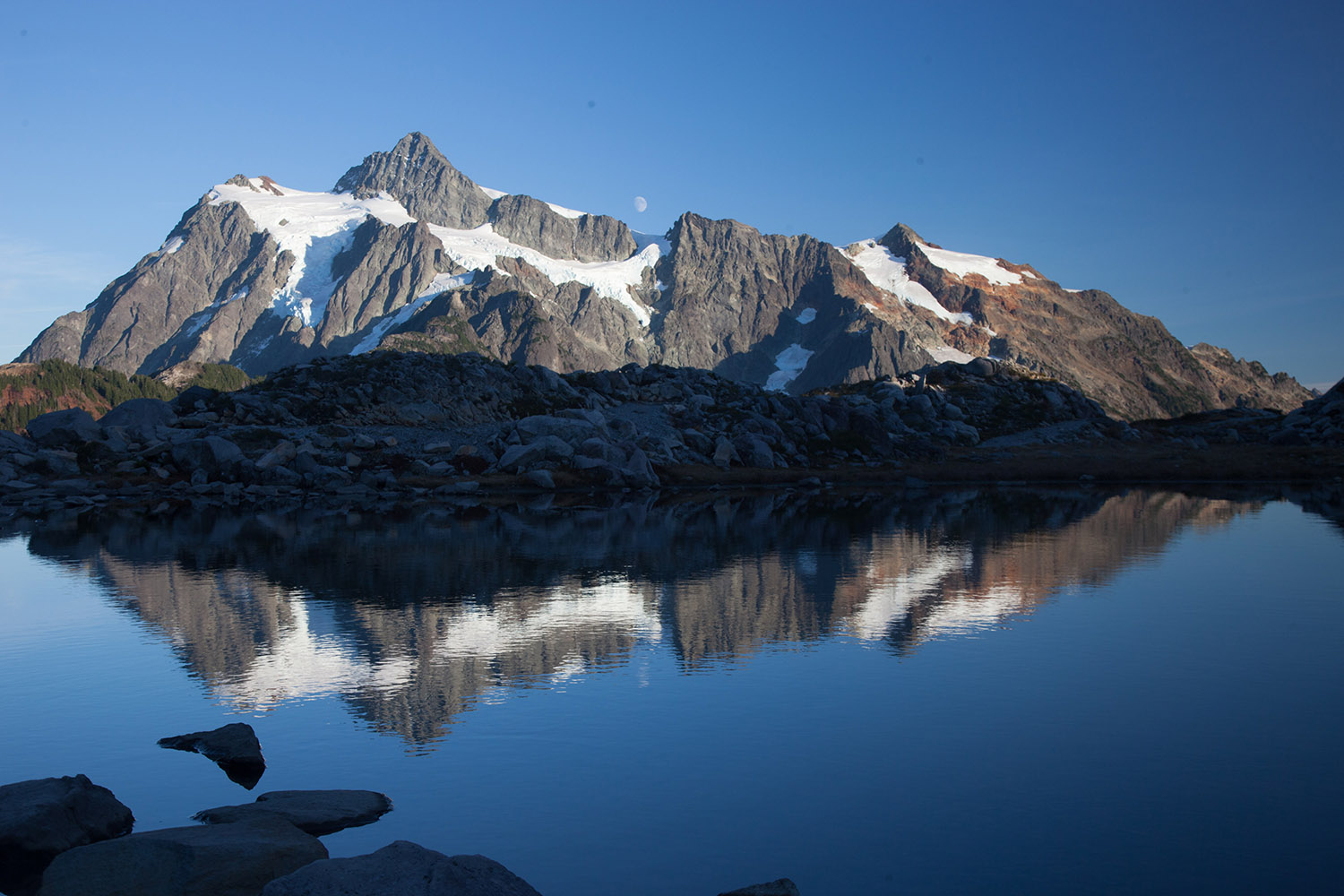
Take this photo of Mt. Shuksan in northern Washington. My daughter Meg and I drove up to the parking lot at Heather Meadows and went for a quick hike to stretch our legs and take some pictures just before sunset.We had about a half hour before the light faded –and all I could think about was taking a photo of this amazing mountain. But the geology? What??
1. Mt. Shuksan and moonrise, northern Washington Cascades.
Thankfully, I’d been there in September scoping out a possible field project with a new grad student, and had the time to reflect… on time. From the ridge we hiked, shown as the dark area in the lower left corner of the left-hand photo below, we could almost feel Shuksan’s glaciers sculpting the mountain into its present shape. Certainly, that process is imperceptibly slow by human standards.
Mt. Shuksan: its glaciated NW side, summit, and outcrop of the Bell Pass Melange.
But the glaciers are sculpting bedrock –and that bedrock reveals its own story, grounded in a much longer time scale.
It turns out that the rock of Mt. Shuksan formed over tens of millions of years on three separate fragments of Earth’s lithosphere, called terranes. These terranes came together along faults that were then accreted to North America sometime during the Cretaceous. At the top of the peak you can find rock of the Easton Terrane. The Easton Terrane contains blueschist, a metamorphic rock that forms under conditions of high pressures and relatively low temperatures, such as deep in a subduction zone. Below that lies the Bell Pass Melange (right photo) –unmetamorphosed rock that is wonderfully messed up. And below that lies volcanic and sedimentary rock of the Chilliwack Group.
Here’s another of my favorites from 2015: the Keystone Thrust! It’s an easy picture to take –you just need to fly into the Las Vegas airport from the north or south, and you fly right over it. It’s the contact between the gray ledgey (ledgy? ledgeee?) rock on the left and the tan cliffs that go up the middle of the photo.
2. Keystone Thrust fault, Nevada–gray Cambrian ridges over tan Jurassic cliffs.
The gray rock is part of the Cambrian Bonanza King Formation, which is mostly limestone, and the tan cliffs consist of Jurassic Aztec Sandstone. Cambrian, being the time period from about 540-485 million years, is a lot older than the Jurassic, which spanned the time 200-145 million years ago. Older rock over younger rock like that requires a thrust fault.
Talk about geologic history… the thrust fault formed during a period of mountain building during the Cretaceous Period, some 100-70 million years ago, long before the present mountains. And the rocks? The limestone formed in a shallow marine environment and the sandstone in a sand “sea” of the same scale as today’s Sahara Desert. We know it was that large because the Aztec Sandstone is the same rock as the Navajo Sandstone in Zion and Arches national parks.
left: Limestone of the Cambrian Bonanza King Formation near Death Valley; right: Cross-bedded sandstone of the Jurassic Navajo Sandstone in Zion NP, Utah.
So… the photo shows cliffs and ledges made of rocks that tell a story of different landscapes that spans 100s of millions of years. But today’s cliffs and ledges are young, having formed by erosion of the much older rock. Then I flew over it in about 30 seconds.
At Beach 2 near Shi Shi Beach in Washington State are some incredible sea stacks, left standing (temporarily) as the sea erodes the headlands. The sea stack and arch in the photo below illustrates the continuous nature of this erosion. Once the arch fails, the seaward side of the headland will be isolated as another sea stack, larger, but really no different than the sea stack to its left. And so it goes.
3. Sea arch and headland at Beach 2, Olympic Coast, Washington.
And of course, the headland’s made of rock that tells its own story –of deposition offshore and getting scrunched up while getting added to the edge of the continent.
Bedrock at Beach 2 consists mostly of sandstone and breccia. The white fragment is limestone mixed with sandstone fragments.
And finally, my last “favorite”. It’s of an unnamed glacial valley in SE Alaska. My daughter and I flew by it in a small plane en route to Haines, Alaska to visit my cousin and his wife. More amazing landscape–carved by glaciers a long time ago. But as you can expect, the rock that makes it up is even older and tells it’s own story.
4. Glacial Valley cutting into Chilkat Mountains, SE Alaska.
Of course, this message of three time scales, the human, the landscape, and the rock-record time scale applies everywhere we go. Ironically, we’re usually in a hurry. I wish I kept it in mind more often, as it might slow me down a little.
A trip to Death Valley over Thanksgiving two weeks ago reignited all sorts of things in my brain, one of which being my love of conglomerate. Honestly, conglomerate HAS to be the coolest rock!
Tilted conglomerate in Furnace Creek Wash, Death Valley.
Just look at this stuff! Just like any good clastic sedimentary rock, it consists of particles of older rock–but with conglomerate, you can easily see those particles. Each of those particles opens a different door to experiencing deep geologic time.
As an example, look at the conglomerate below, from the Kootenai Formation of SW Montana. It contains many different cobbles of light gray and dark gray quartzite and pebbles of black chert. The quartzite came the Quadrant Formation and chert from the Phosphoria Formation. So just at first glance, you can see that this conglomerate in the Kootenai contains actual pieces of two other older rock units.
Conglomerate of the Kootenai Formation, SW Montana.
But consider this: The Quadrant formed as coastal sand dunes during the Pennsylvanian Period, between about 320-300 million years ago and the Phosphoria chert accumulated in a deep marine environment during the Permian, from about 300-250 million years ago. The Kootenai formed as river deposits during the early part of the Cretaceous Period, about 120 million years ago. All those are now together as one.
Similar to the modern river below (except for the glaciers), the Kootenai rivers transported gravel away from highlands –the highlands being made of much older rock that was uplifted and exposed to erosion. That older rock speaks to long gone periods of Earth history while the gravel speaks to the day it’s deposited.
Athabasca River in Jasper National Park, Alberta
But this is where my head starts to spin: the modern gravel is made of rounded fragments of old rock –so when you look at a conglomerate, you glimpse at least two time periods at once: you see the conglomerate, which reflects a river or alluvial fan –or any environment near a bedrock source– and you also see the particles, which formed in even older environments.
And it gets worse –or better. What happens when you see a conglomerate eroding? The conglomerate is breaking up into modern sediment, which consists of pieces of older sediment –that at one time was modern sediment that used to be older sediment? Look at the pebbles below. I keep them in a rusty metal camping cup on a table in my office.
“Recycled” pebbles of the Kootenai Formation.
These stream pebbles eroded out of the Kootenai conglomerate. So… they’re simultaneously modern stream pebbles and ancient ones –AND… they originated as the Quadrant and Phosphoria Formations. Four periods of time, spanning 300 million years, all come together at once.
And if that’s not enough, those conglomerates in Death Valley? They contain particles of… conglomerate! Look! The arrow in the left photo points to the boulder of conglomerate on the right. If you click on the photos, you can see them enlarged.
Conglomerate in Furnace Creek Wash. Arrow points to conglomerate boulder (right)
All those particles, which are now eroding and becoming modern sediment, were yesterday’s sediment. And the conglomerate boulder? It too is becoming “modern sediment” and it too was “yesterday’s sediment” when it was deposited on an alluvial fan with the rest of the material. However, it goes a step further: its pebbles and cobbles were both “modern” and “yesterday’s” sediment at a still older time. And before that? Those pebbles and cobbles eroded from even older rock units, some of which date from the Cambrian, about 500 million years ago.
For fun, here’s a photo of another conglomerate boulder.
Conglomerate boulder in conglomerate of the Furnace Creek Formation, Death Valley, CA.
I can’t help but wonder how Young Earth Creationists would deal with these rocks. Given their story of the Grand Canyon, in which the Paleozoic section was deposited during early stages of “The Flood” and the canyon was carved during the later stages (they really do say that too!), they’d probably roll out that same blanket answer: The Flood. End of discussion. No questioning, no wondering.
In my opinion, one of the beautiful things about geology is that we’re always questioning and wondering.


 From the geologic map, modified from Bishop and Smith, 1990, you can see how the brown-colored canyon-filling basalt, (called the “Intracanyon Basalt”) forms narrow outcrops within today’s Crooked and Deschutes canyon areas. It erupted about 1.2 million years ago and flowed from a vent about 60 miles to the south. You can also see that most of the bedrock (in shades of green) consists of the Deschutes Formation, and that there are a lot of landslides along the canyon sides.