geologictimepics

Geology and Geologic Time through Photographs

Archive for the tag “science”

Where rocks touch: geologic contacts

Geologic contacts are the surfaces where two different rocks touch each other –where they make contact. And there are only three types: depositional, intrusive, or fault. Contacts are one of the basic concerns in field geology and in creating geologic maps –and geologic maps are critical to comprehending the geology of a given area. For those of you out there who already know this stuff, I’ll do my best to spice it up with some nice photos. For those of you who don’t? This post is for you!

Depositional contacts are those where a sedimentary or volcanic rock was deposited on an older rock (of any type). Intrusive contacts are those where igneous rocks intrude older rock (of any type). Fault contacts are… faults! –surfaces where two rocks of any type have moved into their current positions next to each other along a fault.

In a cross-sectional sketch they may look like this:x-sxnlr

And here are some photos. Click on the image to see it at full size.Depositional contact and windows,  Jurassic Entrada Fm (red) ove

So how do you tell them apart in the field? If the actual contact surface isn’t exposed –which is usually the case– you have to use some indirect observations. Here are some general rules that can help. Of course, each “rule” has exceptions, described later. Read more…

Iceland –where you can walk a mid-Atlantic rift –and some other geology photos

While Iceland hosts an amazing variety of awesome landscapes, what stands out to me most are its incredible exposures of the Mid-Atlantic ridge. To the north and south, the ridge lies beneath some 2500m of water, forming a rift that separates the North American plate from the Eurasian plate. The rift spreads apart at a rate of some 2.5 cm/year, forming new oceanic lithosphere in the process. But in Iceland, you can actually walk around in it!

Please click on any of the images below to see them enlarged.

Iceland2geomapplates

Geologic map of Iceland as compiled from references listed below.

Read more…

Hug Point State Park, Oregon, USA –sea cliffs expose a Miocene delta invaded by lava flows

180728-124

Alcove and tidepool at Hug Point

Imagine, some 15 million years ago, basaltic lava flows pouring down a river valley to the coast –and then somehow invading downwards into the sandy sediments of its delta. Today, you can see evidence for these events in the sea cliffs near Hug Point in Oregon. There, numerous basalt dikes and sills invade awesome sandstone exposures of the Astoria Formation, some of which exhibit highly contorted bedding, likely caused by the invading lava. It’s also really beautiful, with numerous alcoves and small sea caves to explore. And at low to medium-low tides, you can walk miles along the sandy beach!

(Click on any of the images to see them at a larger size)

Read more…

Sampling New Zealand’s (Amazing) Geology

New Zealand’s landscape can make just about anybody appreciate geology. Its glaciated peaks, its coastline –that ranges from ragged cliffs to sandy beaches to glacial fjords– its active volcanoes… they all work together to shout “Earth Science!” With that in mind, here’s some basics of New Zealand’s amazing geology, followed by some geological highlights of my trip of January and early February, 2018.

NZ map--all

Map of New Zealand, showing accreted terranes in colors and cover assemblage in gray. (Compiled mostly from Graham, 2015)

North and South Island Bedrock  The different colors on this map show New Zealand’s basement rock, named so because it forms the lowest known bedrock foundation of any given area. The basement tells stories of New Zealand’s deep past, from about 500-100 million years ago. Individual colors signify different terranes, accreted (added) one-by-one through plate motions to the edge of what was then the supercontinent Gondwana. They mostly consist of sedimentary and metamorphosed sedimentary rock, although the narrow belt of purple-colored Dun Mountain Ophiolite formed as oceanic lithosphere, and the red-colored areas consist of granitic igneous rock, some of which has been metamorphosed to gneiss.

Gray indicates the younger cover rock, formed after accretion of the terranes. Consisting of a wide range of sedimentary and volcanic rocks, as well as recently deposited sediment, it’s just as interesting and variable as the terranes. Because it includes volcanoes, it’s largely the cover that gives the North Island its distinctive flair. By contrast, the South Island consists largely of uplifted basement rock, much of which has been –and still is—glaciated. All those long deep lakes, such as Lakes Wanaka and Tekapo, were carved by glaciers and are now floored with their deposits of till.

Andesite stratovolcano, New Zealand

Mt. Ngauruhoe, a 7000 year-old andesite stratocone near Ruapehu on the North Island

Those differences exist largely because the North and South Islands occupy different plate tectonic settings. The North Island sits over a subduction zone, so it hosts an active Read more…

Geologypics.com– A new (and free) resource for geological photographs

What better way to kick off my new website than to write about it on my blog? To see it, you just need to click on the word “home” in the space above. Or you can click the link: geologypics.com.

Here’s part of the front page:
home3

As it says, the site offers free downloads for instructors –and for anybody who’s craving a good geology photograph. It’s my way of contributing to geology education –showing off some of our landscape’s amazing stories and providing resources for other folks who want to do the same.

I think the best part of the whole site is that red button in the middle of the home page. It says “Image Search by Keyword”.

Right now, there are more than 2200 images you can search for — all of which are downloadable at resolutions that generally work for powerpoint. If you search for “sea stack” for example, you’ll get 38 hits –and the page will look like this:

Sea Stack search

First page of sea stacks when you search on the term.


Notice that ALL the photos are presented as squares–which works for most photos, but not all. To help mitigate that, the photos with vertical or panorama formats say so in their title, so you know to click on them to see the whole image. Take the photo in the upper center, for example –it’s got a  vertical format. Here it is:vertial image


A more detailed caption below the photo, along with its ID number appears at the bottom of the pic. This particular image is the chapter opener to the Coast Range in my new book “Roadside Geology of Washington“, which I wrote with Darrel Cowan of University of Washington.

There are also galleries –a chance to browse a variety of images without having to think of keywords. Similar to the search, they’re presented as squares so you need to click on the photo to see the whole thing.


Here’s what the photo gallery page looks like (on the left), followed by part of the “glaciation” page you’d see if you clicked on “glaciation”.  Woohoo!

galleries

part of Galleries page (left) and part of Glacial page (right)


Then there’s the “About” page, which gives some information about me and details my policies regarding use of the images (basically, you can download freely for your personal, non-commercial use if you give me credit; if you want to use the image in a commercial publication you need to contact me to negotiate fees). There’s also a “News” page, that gives updates on the website. There’s a contact page from which you can send me emails. And the blog? It goes right back to here!

And finally, if you’re looking for a great web designer? Try Kathleen Istudor at Wildwood SEO –she created the site and spent hours coaching me on how to manage it.

Enjoy the site!


Summarizing Washington State’s Geology –in 19 photo out-takes

Washington State displays such an incredible array of geologic processes and features that it makes me gasp –which is one reason why writing “Roadside Geology of Washington” was such a wonderful experience. I also got to do it with my long-time friend and colleague (and former thesis advisor at the University of Washington) Darrel Cowan. The book should be on bookshelves in mid-September –and I can’t think of a better way to celebrate than by summarizing Washington’s amazing geology with a bunch of out-take photos –ones that didn’t made it into the book or even to my editor. Like the photo below:

Mount Baker, Washington (150916-4)

Mt. Baker, a glaciated stratovolcano in northern Washington State.

Mount Baker’s a stratovolcano that erupted its way through the metamorphic rock of the North Cascades. I took the photo from the parking lot at a spot called Artist’s Point –at the end of WA 542 –and my editor nixed it because I already had enough snow-capped volcanoes in the book.

On the cross-section below–which includes elements of Oregon as well as Washington, Mt. Baker is represented by the pink volcano-shaped thing labelled “High Cascades”. The following 15 or so photos illustrate most of the other features on the cross-section –so together, they illustrate much of the geology and geologic history of the state!

Cross-section across PNW

Generalized cross-section across Washington and Oregon.

Washington State and geologic provinces

Washington State and geologic provinces.

A quick note about organization: I’m separating the images according to their  physiographic province. There are six in Washington: Coast Range, Puget Lowland, North Cascades, South Cascades, Okanogan Highlands, and Columbia Basin.


Coast Range:
As you can see in the cross-section, the Coast Range borders the Cascadia Subduction Zone and consists of three main elements: the Hoh Accretion Assemblage in yellow, Siletzia (called the “Crescent Formation” in Washington) in purple, and the post-accretion sedimentary rock in brown. Siletzia is the oldest. It was thrust over the Hoh Accretion Assemblage, which is still being accreted at the subduction zone. The post-Accretion sedimentary rocks were deposited over the top of Siletzia after it was accreted about 50 million years ago.

And here are some photos! Siletzia formed as an oceanic plateau and so is characterized Read more…

Science got it right… Maybe we can now accept the reality of climate change?

Along with a zillion other people in the US, I witnessed the total solar eclipse today. Yes, it was amazing and yes, I feel somewhat addicted. The quality of light just before totality was something I’d never before experienced –and the sun’s flash just as it reappeared was something I’ll never forget.  Apparently the next one will be in South America on July 2, 2019–and the next one in the US will be April 8, 2024. Oooh!

Total Eclipse of the sun (170821-19)

Sun’s corona as seen during the total solar eclipse, August 21, 2017 from Salem, Oregon.

Amazing that us humans can accurately predict these phenomena –to the exact place and time –to the second. Seems like our predictions work! These predictions, of course, are grounded in the physical sciences.

At the same time, many people insist that scientists are mistaken or misguided when they predict global climate change.  I wonder if any of those people saw the eclipse. If so, they might want to reflect on their contradiction.

That’s all.

Glacier in retreat, Athabasca Glacier, Alberta, Canada (120713-65).

This monument marks the position of the front of the Athabasca Glacier of Alberta, Canada in the year 2000. Photo taken in 2012.

Washington’s waterfalls–behind each one is a rock!

Of all the many reasons why waterfalls are great, here’s another: they expose bedrock! And that bedrock tells a story extending back in time long long before the waterfall. This posting describes 9 waterfalls that together paint a partial picture of Washington’s geologic history. The photos and diagrams will all appear in my forthcoming book Roadside Geology of Washington (Mountain Press) that I wrote with Darrel Cowan of the University of Washington.

151107-27flr

Rainbow falls along WA 6 in the Coast Range


And waterfalls in heavily forested areas are especially great because they may give the only view of bedrock for miles around! Take Rainbow Falls, for example–the small waterfall on the left. It’s in Washington’s Coast Range along State Highway 6–a place where a roadside geologist could otherwise fall into total despair for lack of good rock exposure. But this beautiful waterfall exposes a lava flow of the Grande Ronde Basalt, which belongs to the Columbia River Basalt Group. Significant? Yes!

This lava erupted in southeastern Washington and northeastern Oregon between about 16 and 15.6 million years ago and completely flooded the landscape of northern Oregon and southern Washington. We know how extensive these flows are because we can see them–and they cover the whole region. The photo below shows them at Palouse Falls in the eastern part of Washington. Take a look at my earlier blog post about the Columbia River Basalt Group? (includes 15 photos and a map).

Read more…

Oregon’s rocky headlands: geologic recycling through erosion and uplift and erosion…

160227-24t

Crashing waves at Heceta Head, Oregon

You can’t avoid thinking about erosion while standing on one of Oregon’s rocky headlands. The waves keep coming, one after another, each crashing repeatedly against the same rock. Impossibly, the rock appears unmoved and unchanged. How can it not erode?

The answer, of course, is that headlands do erode, quickly, but on a geologic time scale. We just miss out because we live on the much shorter human time scale. And the erosion belongs to a cycle in which coastal uplift causes eroded and flattened headlands to rise and become headlands once again, all subject to more ongoing erosion and uplift.

Wave energy is most intense at headlands because the incoming wave typically feels the ocean bottom near the headland first, which causes the wave to refract. As shown in the aerial photo below, this refraction focuses the wave energy on the headland.

CE-06060115-33-arrowsc

Wave refraction causes wave energy to focus on the headland. Arrows are perpendicular to wave fronts.

As you can see in the next few images, headlands don’t erode evenly. They erode irregularly, as the waves exploit any kind of weakness in the rocks such as faults and fractures, or if they’re sedimentary, bedding surfaces. The products of this erosion are as beautiful as they are interesting: sea stacks, sea arches, sea caves… The list goes on and on.

Headland and lighthouse, Heceta Head, Oregon

Aerial view of Heceta Head, Oregon.

From the above photo, you can see that sea stacks are simply the leftover remains of a headland as it retreats from erosion. That’s a critical point, because some sea stacks, especially the one with the arch in the photo below, are a long way from today’s coastline.

Sea stacks and sea arch, southern Oregon

Sea stacks and sea arch, southern Oregon

Those rocks, 1/4 to a 1/2 mile away used to be a part of the coastline? The land used to be way out there? YES!!! For me, that’s one of the very coolest things about sea stacks –they so demonstrate the constant change taking place through erosion.

Taken to its extreme, erosion renders headlands into wave-cut platforms, such as the one below at Sunset Bay. Being in the intertidal zone, these platforms make great places for tide-pooling–and ironically, for people-watching too. Geologically, they form important markers because they’re both flat and form at sea level. When found at higher elevations, they indicate uplift.

Wave-cut bench, Sunset Bay, Oregon

Wave-cut bench at Sunset Bay, Oregon

In fact, looking carefully at the photo above, you can see a flat surface on the other side of the bay. It’s an uplifted wave-cut platform! Called a marine terrace, it’s covered by gravel and sand originally deposited in the intertidal zone. Those deposits rest on bedrock that, at an earlier time, was also flattened by the waves. The photo below shows a better view of this terrace from the other side.

5D-8922clr

Breaking wave at Shore Acres State Park, Oregon. Tree-covered flat surface in the background is an uplifted marine terrace.

These uplifted marine terraces can be found up and down Oregon’s coastline. Researchers recognize several different levels, the oldest being those uplifted to highest elevations. The one in the photo above at Shore Acres State Park is called the Whiskey Run Terrace and formed about 80,000 years ago. You can see a similar-aged terrace below as the flat surface beneath the lighthouse at Cape Blanco, Oregon’s westernmost point. An older, higher terrace forms the grass-covered flat area on the right side of the photo.

Cape Blanco, Oregon

Cape Blanco, Oregon looking NE. The flat surface beneath the lighthouse is the ~80,000 year-old Cape Blanco Terrace, probably equivalent to the Whiskey Run Terrace at Shore Acres; the flat area on the right side of the photo is the higher Pioneer Terrace,  formed ~105,000 years ago.

Researchers take the approximate ages of the terraces and their elevations to calculate approximate rates of uplift. In this area, Kelsey (1990) estimated a rate of between 4-12 inches of uplift every 1000 years. That might seem slow, but over hundreds of thousands of years, it can accomplish a great deal.

And look! The uplifted terraces? They’re on headlands! Of course, because they’ve been uplifted! And the headlands are now eroding into sea stacks and then platforms –to be uplifted in the future and preserved as marine terraces that sit on top headlands. And on and on, as long as the coastline continues rising.

YachatsWaves1-4

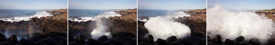
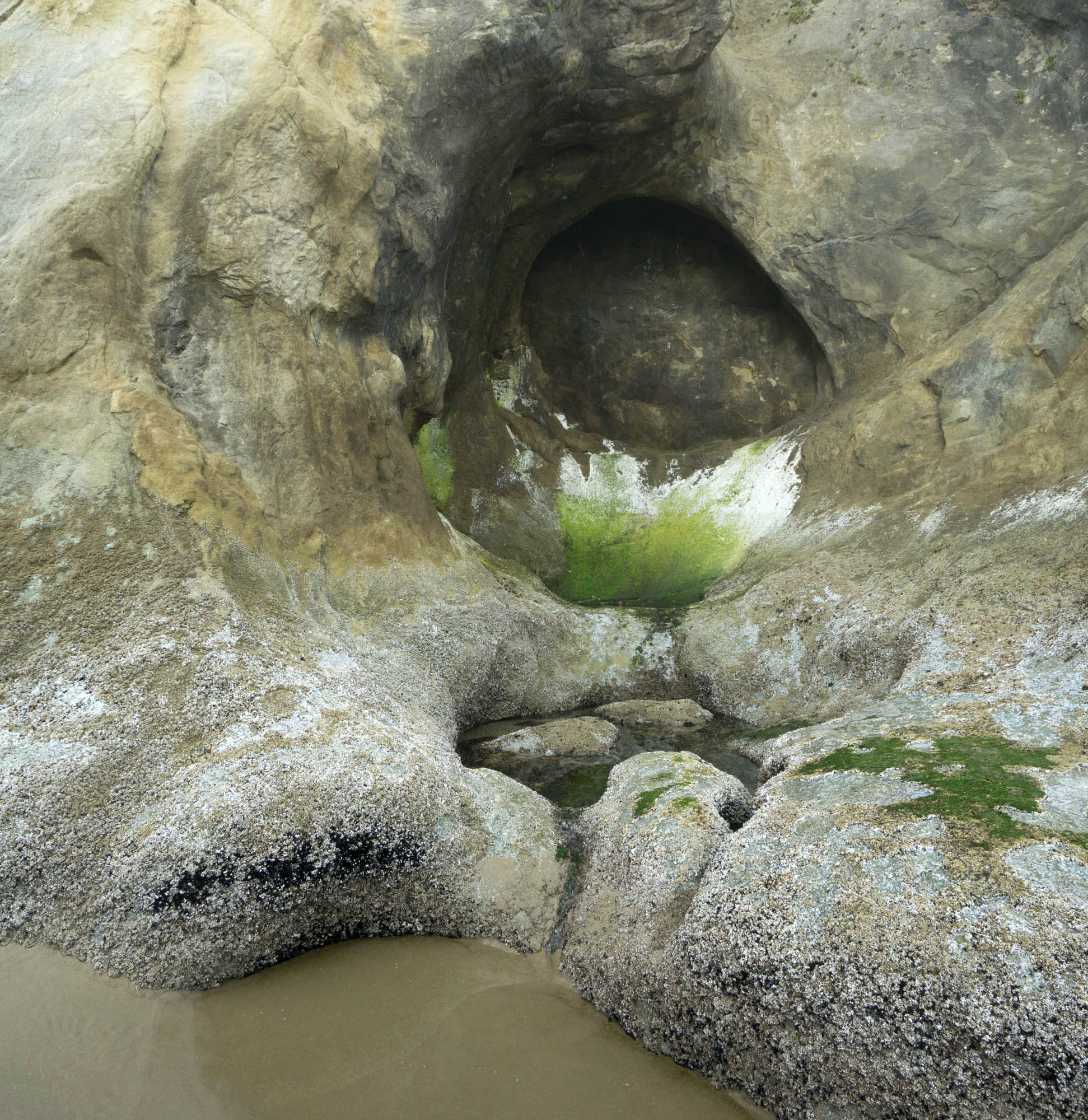
Blowhole near Yachats, Oregon. Incoming wave funnels up a channel eroded along a fracture and explodes upwards on reaching the end.

Some links and references:
Kelsey, H.M., 1990, Late Quaternary deformation of marine terraces of the Cascadia Subduction Zone near Cape Blanco, Oregon: Tectonics, v. 9, p. 983-1014. (Detailed study of Cape Blanco, including uplift rates).

Miller, M., 2014, Roadside Geology of Oregon, Mountain Press, Missoula, 386p. (General reference which details the concepts and includes several of the photos used here).

Earth Science Photographs: free downloads for Instructors —or anybody! (my webpage)

Scientists, Science, Icicles, and Faith

In January, I started teaching the Introductory Geology course “Environmental Geology and Landform Development” –with two lecture sections of about 200 students each. And this course, populated largely by folks who are fulfilling a science requirement and  otherwise try to avoid science like it was the plague, needed some general statement about science. After all, it’s science that may someday save them from the plague!

So science… what is it? Seems like scientists themselves have a zillion different definitions, so I started with “Scientist. –What’s a scientist?” If you google “scientist” and then look at the images, you see this. As this image is a screenshot of photos that aren’t mine, I intentionally blurred it, but you should get the idea of what’s there.

lec1-allrb

Really??? these are the most popular images of scientists and in every picture–save the tiny one in the lower right– is some person in a WHITE LAB COAT and a microscope or a beaker. Ironically, it shows about 50% of the scientists as women. Go figure there too.

Looks like we’ve been fed a misrepresentation of what scientists are. We actually do a wide variety of things. In geology, we do a wide wide range of things. We spend time in the field (see picture below), we write, we draw maps and cross-sections, we look down microscopes (maybe in jeans and t-shirts), we write computer models, we do experiments, and we sometimes wear white lab coats.

130324-17c

Geologist inspecting a fault zone between the dark-colored Beck Spring Dolomite and the overlying light-brown Noonday Dolomite. Death Valley, California.

All the time, we’re trying to understand something about our world. Our universe. We’re collecting information (data). We’re testing ideas. We’re adding detail to somebody else’s ideas. We’re building a framework of knowledge that’s grounded in our observations and testable ideas. Replace the word “ideas” with “hypotheses” in this paragraph –and you get science.

Ideally, most scientists approach their work using the “scientific method” –which is a highfalutin way of saying they see something they don’t understand (an observation), which causes them to ask a question (like how did this happen?); they come up with ideas (hypotheses) that may explain it, and then they test those hypotheses.

ice-stufflr

Icicles?

Which is what we did in class with icicles! The month before–in mid-December–Eugene had this incredible ice storm, which covered everything in ice to make it look like a scene from the movie Frozen. It was beautiful and destructive. And we can all pretty much guess how icicles form: water starts to drip off the branch but freezes before it falls off. Icicles grow straight downward off the branch because water, like everything else, falls vertically with gravity.

As it turned out, some of the icicles seemed to grow straight out from the branches. Look at the photo below! How could this be? We know icicles should grow straight downwards! So as a group, we came up with some hypotheses, shown below next to the picture. I was the proud sponsor of hypothesis #4 and #5.

lec1-c

Alternate hypotheses to explain near horizontal growth of icicles

As a group (all 200 of us), we could rule out hypothesis #3, that the picture was rotated. I shot the image and promised I didn’t rotate it! We could also rule out hypothesis #4, that the ice somehow grew horizontally towards the branch, because that idea conflicted with all previous observations we’d made on icicles, that they grow away from the branch as ice progressively freezes.

That left hypotheses #1, #2, #5. We figured ways we could test #1, #2. If it were the wind, for example, we’d expect all the icicles to go in one direction in a given place, regardless of the limb angle. If it were #2, we might expect to see some icicles show a curve to indicate progressive tilting of the branch–which you can actually see in the photo above!

Hypothesis #5, that “Some magical force caused it to grow sideways”isn’t testable. It’s NOT TESTABLE. We can’t come up with ways to support it or rule it out. You can believe it if you want to, but it’s not science.

That’s the point. To be scientific, a hypothesis must be testable. Most of us hold various non-scientific beliefs in our hearts that we know to be true –for us. I think that’s a good thing. For many of us, those beliefs lend us qualities like strength or courage or compassion when we need them the most. They’re still not scientific.

And that’s what really gripes me about the “scientific creationists” –as well as today’s Republican Party. The “scientific creationists” say they use science to demonstrate the existence of God, or that Earth is young –when believing either requires a suspension of science and an act of Faith. By claiming they’re being scientific, the “scientific creationists” hamstring their own belief system. They take the wonder out of religion and render it baseless and sterile.

And the Republicans? They’re now all about “alternative facts”. Maybe it’s unfair to group “all Republicans” together –but I see very few standing up to this reckless leader we have. Maybe they just lack integrity.

161215-7lrcrot

this photo was rotated

Post Navigation