Washington’s waterfalls–behind each one is a rock!
Of all the many reasons why waterfalls are great, here’s another: they expose bedrock! And that bedrock tells a story extending back in time long long before the waterfall. This posting describes 9 waterfalls that together paint a partial picture of Washington’s geologic history. The photos and diagrams will all appear in my forthcoming book Roadside Geology of Washington (Mountain Press) that I wrote with Darrel Cowan of the University of Washington.
Rainbow falls along WA 6 in the Coast Range
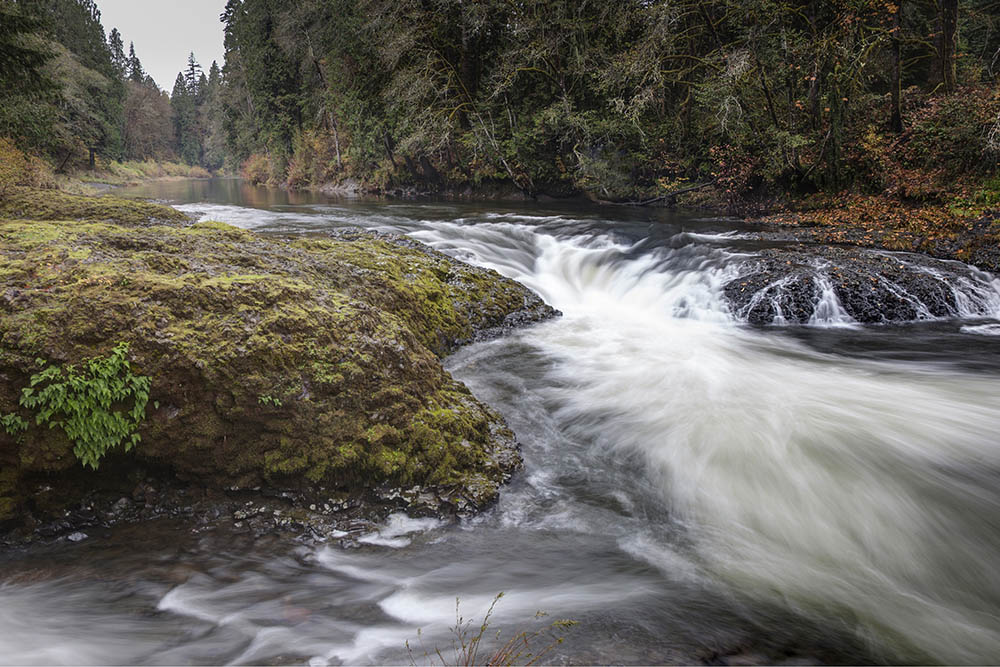
And waterfalls in heavily forested areas are especially great because they may give the only view of bedrock for miles around! Take Rainbow Falls, for example–the small waterfall on the left. It’s in Washington’s Coast Range along State Highway 6–a place where a roadside geologist could otherwise fall into total despair for lack of good rock exposure. But this beautiful waterfall exposes a lava flow of the Grande Ronde Basalt, which belongs to the Columbia River Basalt Group. Significant? Yes!
This lava erupted in southeastern Washington and northeastern Oregon between about 16 and 15.6 million years ago and completely flooded the landscape of northern Oregon and southern Washington. We know how extensive these flows are because we can see them–and they cover the whole region. The photo below shows them at Palouse Falls in the eastern part of Washington. Take a look at my earlier blog post about the Columbia River Basalt Group? (includes 15 photos and a map).

Palouse Falls in eastern Washington drops more than 180 feet over lava flows of the Grande Ronde and Wanapum members of the Columbia River Basalt Group.
You might also notice in the photo above that the waterfall is actually pretty small compared to its amphitheatre. That’s because Palouse Falls is part of another flood story –of the Ice Age Floods, described in rich detail on the Ice Age Floods Institute website. Basically, some 40 or 50 gigantic floods coursed through the area towards the end of the Ice Age, between about 15-18,000 years ago. and among other things, carved this canyon. Lobes of the continental ice sheet repeatedly dammed the Clark Fork River in northern Montana and then failed, repeatedly, after forming Glacial Lake Missoula. Imagine the flow volume in the above photo multiplied more than 100,000 times!
Mount Rainier and the Cascade Volcanoes

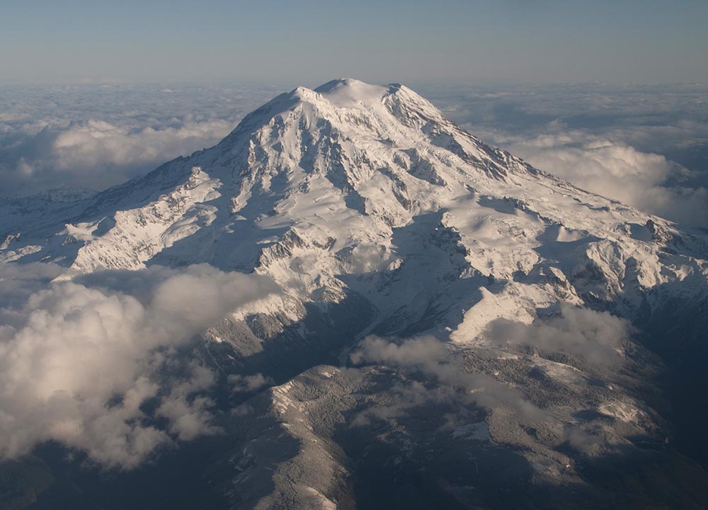
At 14,410 feet above sea level, Mount Rainier is the highest volcano in the Cascade Range –and one of the highest spots in the conterminous United States. The volcano itself consists mostly of andesite flows that date back nearly a half million years.
Beneath those lava flows are older rocks that speak to a history of volcanic activity reaching back 70 times that of Rainier’s oldest lavas –to about 35 million years ago. At Christine Falls, you can inspect granitic rock of the Tatoosh Pluton, which is a crystallized magma chamber that formed beneath some early Cascade volcanoes. It was probably active at different times between 26-14 million years ago. At Narada Falls, you can see where Rainier andesite actually flowed over the top of the granite–which tells us that the granite was exposed at the surface 40,000 years ago when that flow erupted. Both these waterfalls are right along the road that winds its way from Longmire up towards Paradise Meadows.

Christine Falls (left) cuts through granitic rock of Tatoosh Pluton; Narada Falls (right) flows over Rainier Andesite that itself flowed over Tatoosh granodiorite, exposed on the rocky hillside.
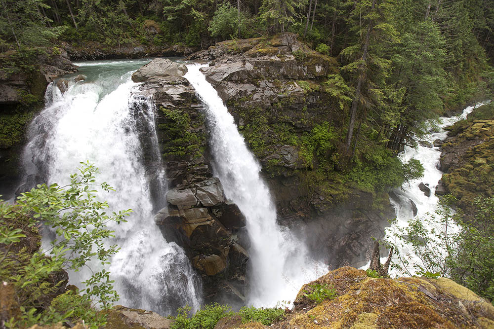
If you go to the south entrance of the national park, you can walk a quarter mile from the highway to Silver Falls and exposures of Rainier’s oldest rocks. The Ohanapecosh Formation, made mostly of tuffs and re-deposited volcanic particles, formed by explosive volcanic activity that stretches back 35 million years. The Ohanapecosh Formation forms cliffs throughout much of the national park –and shows up northward as far as Interstate 90.

Silver Falls in Mount Rainier National Park, spills over outcrops of Ohanapecosh Formation, the park’s oldest rock.
Finding the oldest volcanic rock in the Cascade Volcanoes is important because this incredibly active volcanic chain is fueled by magma generated through the sinking of oceanic lithosphere at the Cascadia subduction zone –and the oldest rocks allow us to estimate when this process started. They get even older at Snoqualmie Falls, just north of I-90. There, rocks of the Mount Persis Volcanics reach ages of 38 million years. Most geologists agree that for Washington, these rocks mark the first volcanic activity after the formation of the Cascadia subduction zone.
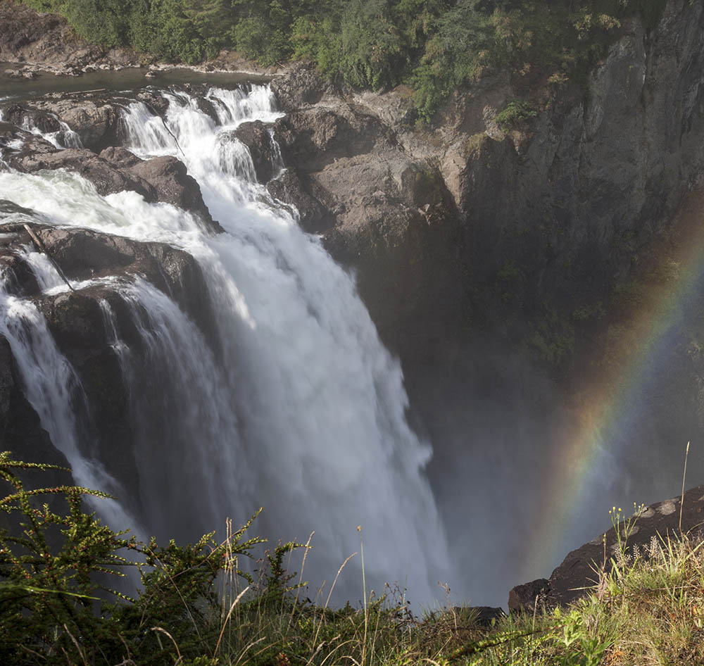
Snoqualmie Falls drops more than 250′ into a gorge of Mt. Persis Volcanics –rocks that mark the onset of volcanic activity related to today’s Cascadia subduction zone.
Early Volcanic Roots and Continental Accretion
Here it gets a little complicated, because subduction also drove much of Washington’s geologic history before the Cascade volcanoes started to form. This older subduction also formed volcanic chains and through the process of continental accretion, caused Washington to grow westward.
 This diagram, modified from my book Roadside Geology of Oregon, illustrates the process of accretion. Basically, some element of the subducting seafloor is unable to fully sink beneath the continent, probably because it’s topographically high– such as with a series of seamounts. This material jams up the subduction zone and causes the sinking to stop temporarily. Eventually, a new subduction zone forms farther offshore and the thing that jammed up the zone in the first place gets added, or accreted, to the edge of the continent. In Washington and Oregon, the younger Cascadia subduction zone is the one that formed the Cascade Volcanoes and the stuff that jammed the zone was a huge fragment of oceanic lithosphere called “Siletzia”. Siletzia now makes up the bottom of Washington and Oregon’s Coast Range. The older subduction zone that got jammed up is the one that’s responsible for the rocks described below.

Gorge Creek cuts a slot through orthogneiss (inset) of the Skagit Gneiss Complex along State Highway 20 in Washington’s North Cascades.
Gorge Falls along State Highway 20 in the North Cascades cuts this narrow slot through rocks formed because of that older subduction zone. These rocks started as the granitic roots to volcanoes, much in the same way as the Tatoosh Pluton formed the roots to some Cascade volcanoes. Those roots then got squeezed and reheated to make a metamorphic rock called gneiss. In some places it even partially re-melted.
The inset gives a close-up view of the rock. It’s called “orthogneiss” because it started out as an igneous rock. It forms a big part of the Skagit Gneiss Complex, which makes up the core of the North Cascades.
It’s hard to say if the Skagit Gneiss Complex was actually added to the edge of North America from somewhere else, but a lot of other rocks in Washington were–and those episodes of accretion are what caused much of the metamorphism in the North Cascades.
For accreted rock, here’s probably my favorite waterfall: Nooksack Falls, along State Highway 542 between Bellingham and the Mt. Baker ski area. It’s made of conglomerate of the Nooksack Group, which accumulated in a submarine fan somewhere off the coast of North America during the Jurassic and Cretaceous Periods, maybe 140 million years ago.
Nooksack Falls in the North Cascades. the horizontal lines across the falls mark traces of bedding in the rock that’s inclined directly upstream.
Ancient North America
If you go eastward towards Spokane, you eventually find yourself on the North America that existed before all this accretion. Of course, much of the area is now covered by the Columbia River Basalt, but in the northeast corner of the state, you encounter Paleozoic sedimentary rocks that formed along the continental margin of that older continent. Sweet Creek Falls is one place to see these rocks, right off State Highway 31. There, the beautiful stream spills over ledges of Ledbetter Slate, deposited as shale during the Ordovician Period. In the foreground are cobbles of Addy Quartzite, formed as beach-deposited sandstone in the Cambrian.

Sweet Creek Falls spills over Ledbetter Slate. Cobbles of Addy Quartzite lie in the foreground.
Washington’s Geologic Timeline
The timeline below shows Washington’s main geologic events –and you can see where these 9 waterfalls fit. The red text and red-colored bars represent geologic events represented by individual waterfalls, shown in blue. Kind of amazing… these 9 waterfalls show many of Washington’s most important elements: the Cascade Volcanoes, the Columbia River Basalt Group, continental accretion, and the old continental margin.
And they’re nice places to hang out!
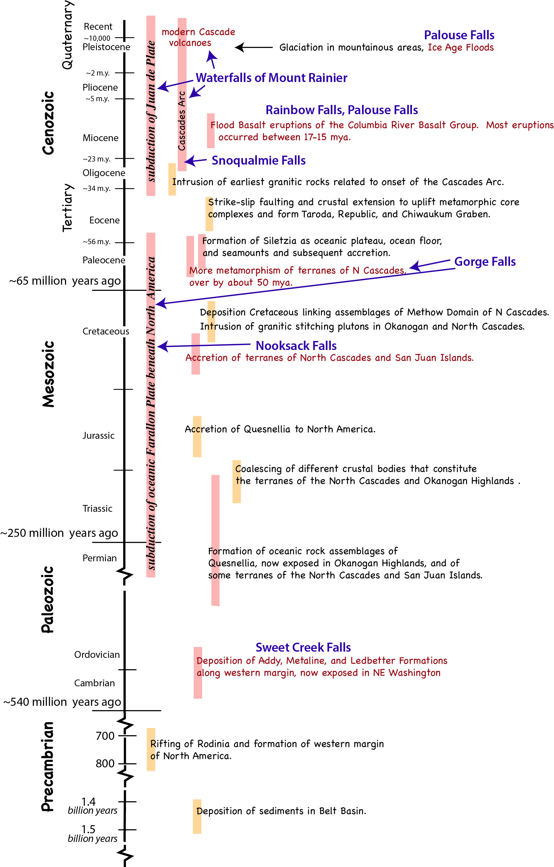
Timeline of Washington’s geology. Red text signifies events described in this post and represented by various waterfalls (in blue).
For more geology photos, please check out my website–it contains a searchable database of more than 2000 geology photos for free download.
Roadside Geology of Washington should be out and available in August, 2017.
Thanks for reading!

Beautiful. It will encourage readers (though perhaps yours don’t need such encouragement) to see landscape in context, enhancing their pleasure. My only regret is that the images have no click-to-expand, which would add greatly to their value
LikeLike
Thanks for the nice comment! –and “click-to-expand”- do you know how I can make it do that? I thought it was automatic, as I noticed it on an earlier post, but apparently not!
LikeLike
I am no expert, and this may also depend on which WordPress theme you’re using, but I have found that if I save a jpeg image to computer and then transfer it to my post using “add media” and “retrieve files from computer” it is transferred to my WordPress library and I am asked if I want to insert into text. The answer of course is yes. Clicking on the image in the draft enables me to choose its size and location, whether there is text to one side, and to write a caption. Simply hovering over the image in the actual post (or preview, but not draft) turns the cursor into a hand, and clicking bbrings up an expanded image which can be expanded further.
I’m not sure that this always works but it does a lot of the time. Visit for example my post https://paulbraterman.wordpress.com/2014/12/14/time-turned-to-stone-part-2-the-giants-causeway-time-as-process/ which I’m pretty sure you’ve seen.
LikeLike
thanks Paul! I’m not sure just what I did –so I’ll have to give that a try.
LikeLike
Hi Paul!
Just wanted to let you know that I just learned how to make my images appear at full size when you click on them! Thanks for the suggestion –and the waterfall post is fixed now!
LikeLiked by 1 person
hello this was really cool to see I was working on a project on waterfalls and stumbled across this web-sights It really helped me with research
LikeLike
thank you– I’m glad it was helpful! 🙂
LikeLike