geologictimepics

Geology and Geologic Time through Photographs

Archive for the tag “gneiss”

Glacially carved granite in Rocky Mountain National Park, Colorado

This landscape is so smooth and rounded that you can easily imagine the ice that must have covered it some 20,000 years ago.  And the ice must have been deep!  Look halfway up the mountain in the foreground on the left; it shows a distinct change of rock weathering akin to a bathtub ring–and the ring persists around much of the photo.  It likely marks the upper surface of the ice at maximum glaciation.

140809-94
Upper Glacier Gorge, a glacial cirque in Rocky Mountain National Park, Colorado.  View of the Spearhead (left) and McHenry’s Peak (just behind)

Like most landscapes, this one’s pretty young–and those glacial effects are even younger.  When compared to the age of the rock, it seems almost insignificant.  The granite bedrock, which is granite, is 1.4 billion years old!  Elsewhere in Rocky Mountain National Park, the granite intrudes even older metamorphic rock –1.7 billion years old.  Just .3 billion years older.  I think we forget that “just .3 billion years” is 300 million years –about the same length of time as the entire Paleozoic!  And the Pleistocene Epoch, during which the glaciers grew?  It started some 2 million and ended about 10,000 years ago

Granite sill intruding gneiss, Colorado.
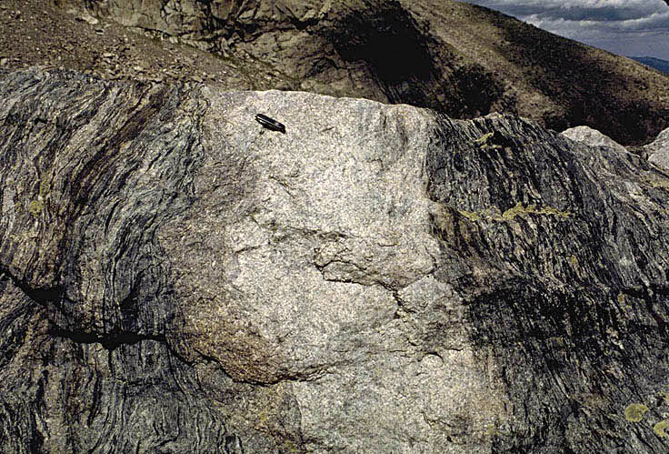
1.4 billion year old granite intruding 1.7 billion year old gneiss in Rocky Mtn National Park.


images can be downloaded for free at marlimillerphoto.com

Great Unconformity in Montana –and rising seas during the Cambrian

Here’s yet another picture of the Great Unconformity –this time in southwestern Montana.  Once again, Cambrian sandstone overlies Precambrian gneiss.  You can see a thin intrusive body, called a dike, cutting through the gneiss on the right side.  You can also see that the bottom of the sandstone is actually a conglomerate –made of quartzite cobbles derived from some nearby outcrops during the Cambrian.

Great unconformity in SW Montana.

Photo of Cambrian Flathead Sandstone overlying Proterozoic gneiss in SW Montana.


And that’s me in the photo.  My left hand is on the sandstone –some 520 million years or so old; my right hand is on the gneiss, some 1.7 BILLION years old.  There’s more than a billion years of missing rock record between my two hands.  Considering that the entire Paleozoic section from the top of the Inner Gorge in the Grand Canyon to the top of the rim represents about 300 million years and is some 3500′ thick… yikes!

And… just like in the Grand Canyon and elsewhere, there is Cambrian age shale and limestone above the sandstone.  This rock sequence reflects rising sea levels during the Cambrian.  It’s called the “Cambrian Transgression”, when the sea moved up onto the continent, eventually inundating almost everywhere.  If you look at the diagram below, you can see how this sequence formed.

Marine transgression

Sequence of rock types expected during a transgression of the sea onto a continent.

If you look at time 1, you can see a coastline in cross-section, with sand being deposited closest to shore, mud a little farther out, and eventually carbonate material even farther out.  As sea levels rise (time 2), the sites of deposition for these materials migrates landward, putting mud deposition on top the earlier sand deposition and so on.  At time 3, the sequence moves even farther landward, resulting in carbonate over mud over sand.  If these materials become preserved and turned into rock, they form the sequence sandstone overlain by shale overlain by limestone –just what we see on top the Great Unconformity.


Great Unconformity –in the Teton Range, Wyoming

As it turns out, the “Great Unconformity”, the contact between Cambrian sedimentary rock and the underlying Precambrian basement rock, is a regional feature –it’s not only in the Grand Canyon, but found all over the Rocky Mountain West –and for that matter, it’s even in the midwest.  As an example, here are a couple photos from the Teton Range in Wyoming.

The yellow arrow points to the contact between the Cambrian Sandstone and underlying Precambrian metamorphic rock... the Great unconformity.

This top photo shows the Grand Teton (right) and Mt. Owen (left) in the background… in the foreground, you can see a flat bench, which is underlain by flat-lying Cambrian sandstone.  Below that are darker-colored cliffs of Precambrian metamorphic rock.  The unconformity is right at their contact (arrow).

Also notice that the Grand Teton and Mt. Owen are made of metamorphic (and igneous) rock –but they’re much much higher in elevation than the sandstone.  That’s because there’s a fault, called the “Buck Mountain fault” that lies in-between the two.  The Buck Mountain fault moved the rock of the high peaks over the ones in the foreground during a mountain-building event at the end of the Mesozoic Era.  Because the metamorphic and igneous rock is so much more resistant to erosion than the sandstone, it stands up a lot higher.

Precambrian metamorphic and igneous rock of the Teton Range and overlying sedimentary rock.

This lower photo shows the view of the Teton range from the top of the sandstone bench (appropriately called “Table Mountain”).  As you look eastward towards the range, you can pick out the Buck Mountain fault (between the metamorphic and igneous rock of the high peaks) and the Cambrian sedimentary rock (the layered rocks).  Significantly, the Cambrian rocks, just like in the Grand Canyon, consist of sandstone, overlain by shale, overlain by limestone.

And geologic time… remember… for the sandstone to be deposited on the metamorphic or igneous rock, the metamorphic and igneous rock had to get uplifted from miles beneath the surface and exposed at sea level.  And since then, it’s been uplifted to the elevation of The Grand Teton (13370′) and Mt. Owen (12, 928′) !

Click here to see more photos of unconformities.
or… click here to see a geologic map of Grand Teton National Park, Wyoming.

Metamorphic Rock

Metamorphic rock, just its very existence at Earth’s surface, signifies great lengths of geologic time –on the order of millions of years.

Consider this rock, high in the Teton Range of Wyoming.

Folded gneiss, formed at depths of 10 km or more, high in the Teton Range of Wyoming.

This is a metamorphic rock called gneiss –in a lot of ways, it’s like granite, because it contains a lot of the same minerals –but gneiss forms because an older rock (in this case, probably a granite) was heated to high enough temperatures that its minerals recrystallized into new minerals.  And most metamorphism also involves high pressures, so all the new crystals form in a particular arrangement (as opposed to granite, in which the crystals are randomly arranged) –that’s how the layering (called “foliation”) forms in metamorphic rocks: the recyrstallization of new minerals under pressure.

Close-up view of gneiss, showing crystals that formed in the same orientation, as a result of recrystallization while under directed pressure. The layering is called "foliation"

But the key thing here, is that metamorphic rocks form WITHIN the Earth, at depth –and just like granite, require uplift and erosion to get to the surface.  This gneiss formed at depths of 10 km or more and was then uplifted to its present elevation, nearly 4 km above sea level.  –which requires time.

click here to see more photos of metamorphic rocks
click here to see a geologic map of Grand Teton National Park, Wyoming.

Post Navigation

%d bloggers like this: