Shaping of Landscape: A primer on weathering and erosion
Most of us love landscapes –and many of us find ourselves wondering how they came to look the way they do. In most cases, landscapes take their shape through the combined processes of weathering and erosion. While weathering and erosion constitute entire fields of study unto themselves, this primer outlines some of the basics—which pretty much underlie all the further details of how natural processes shape landscapes.

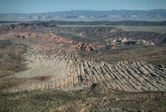
Aerial view of incised meanders of Green River, Utah.
Two definitions: weathering describes the in-place breakdown of rock material whereas erosion is the removal of that material. Basically, weathering turns solid rock into crud while erosion allows that crud to move away.
Weathering
Weathering processes fall into two categories: physical and chemical. Physical weathering consists of the actual breakage of rock; any process that promotes breakage, be it enlargement of cracks, splitting, spalling, or fracturing, is a type of physical weathering. Common examples include enlargement of cracks through freezing and thawing, enlargement of cracks during root growth, and splitting or spalling of rock from thermal expansion during fires.
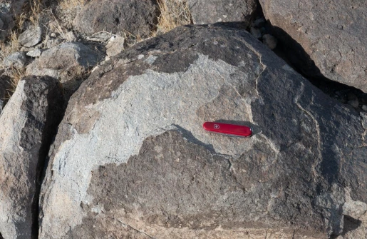
Spalling of volcanic rock–likely from thermal expansion during a fire.
Chemical weathering alters the composition of the rock and is critical for soil development. The most prevalent processes are oxidation of iron-rich minerals, dissolution of material, most notably of the calcium carbonate that makes up limestone or the cement of many sandstones, and hydrolysis, which turns feldspars and micas to clay. As chemical processes all require water to proceed, they are most active in wet, warm climates, and least active in dry cold ones.

Strongly chemically weathered granitic rock above less weathered granitic rock.

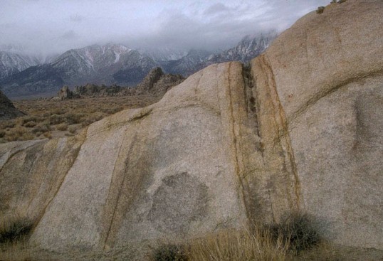
Disintegration of granitic rock through hydrolysis of feldspars
Physical and chemical weathering processes help each other degrade rocks. By breaking rock into smaller pieces, physical weathering processes greatly increase the surface area over which chemical processes can attack. At the same time, chemical processes greatly weaken a rock’s strength and make it more susceptible to breakage. Chemical weathering of individual mineral grains also increases their volume, which itself leads to fracture.
Chemical weathering (oxidation and hydrolysis) concentrated along fractures in granitic rock.
Erosion
In contrast to breaking things down in-place, erosion removes material, typically through gravity, water, or wind. The single most important influence is gravity, which drives processes such as rock falls, avalanches, and debris flows. Most erosion, however, is a product of gravity and water acting together: water facilitates gravity-driven processes like debris flows, and gravity ultimately lies behind the power of water. Wind can also be important, but is a relatively minor contributor overall because it can transport only the finer-grained particles.

Rock avalanche deposit, Utah
Weathering and Erosion together
Weathering and erosion work hand-in-hand in their creation of landscapes. Weathering processes break exposed bedrock into smaller and weaker fragments, which allows erosion to proceed. By removing that material, erosion then exposes new bedrock to weathering processes.
Landscape and Bedrock
Besides telling us about Earth history, the bedrock of a particular place helps determine how it looks. The bedrock provides the initial block of clay, so to speak, that is carved by weathering and erosion to create the landforms at the surface. As a result, the shape of the landscape depends on the actual type of rock and its structure– that is, its orientation, relationship to other rock types, and presence or absence of fracture or fault zones. For example, some rock types are easily weathered and removed by erosion while others are extremely resistant, and these may show through as topographic lows and highs respectively.
Resistant sandstone forms a “hogback ridge” whereas less resistant shale and mudstone form gullies, Utah.
While a number of factors affect a rock’s resistance to weathering and erosion, the single most important one is its ability to repel water. As a result, prevalence of bedding in sedimentary rock or foliation in metamorphic rock, both of which allow water penetration, decrease the resistance. By the same reasoning, increased grain size tends to increase resistance because coarser grains offer less surface area for a given volume. Similarly, stronger cementation in sedimentary rocks increases resistance, as does the crystalline nature of metamorphic rocks. Carbonate rocks, such as limestone and dolomite, provide interesting exceptions to these rules. In arid environments, they are resistant, but in wetter climates where they can dissolve, they are not resistant.
Sandstone beds, being coarser grained and thicker bedded than the red-colored shale and siltstone, stand out in relief because they are more resistant to erosion. Utah.
As the single most important factor in weathering and erosion is water, it stands to reason that the presence of fractures or fault zones in rock, which tend to localize water flow, greatly influences the landscape. Additionally, movement along fault zones tends to crush some of the adjacent rock, which makes them even easier to erode. As a result, fractures and faults frequently form canyons or valleys. For example, at Arches and Canyonlands national park in Utah, vertical fractures erode into slot canyons to leave the intervening, non-fractured rock standing upright as narrow ridges called fins. Some of these fins erode in from their sides to form arches. At Pt. Reyes National Seashore in California, Tomales Bay protrudes inland as a long narrow bay eroded along the San Andreas fault. Click here to see a post about the San Andreas fault!
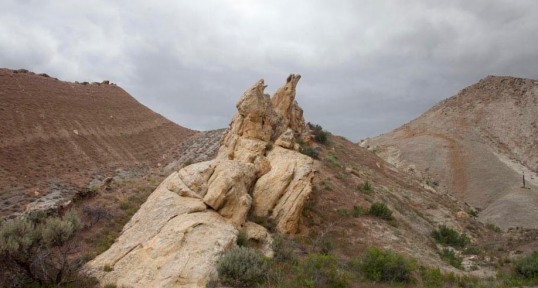
Vertical fractures in sandstone eroding into fins, Arches National Park, Utah.
The vertical changes in a sequence of sedimentary rocks show the most predictable, yet dramatic, impacts on landscape, especially in arid landscapes. In flat-lying rocks, such as in many parts of the Colorado Plateau, the resistant rock units form cliffs whereas more easily erodable units form slopes. The easily eroded slopes are typically littered with large blocks from the cliffs above. These blocks fall when erosion of the slopes undercuts the cliffs and gravity takes over.
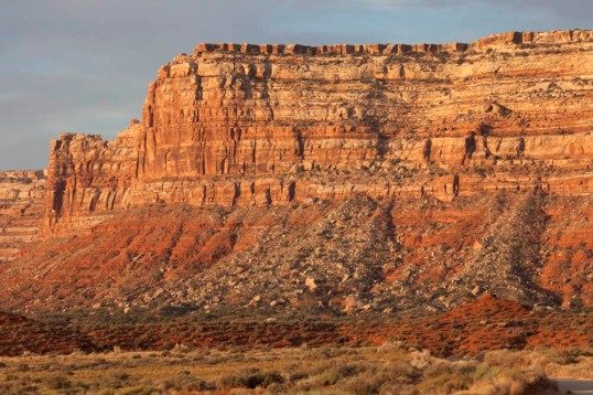
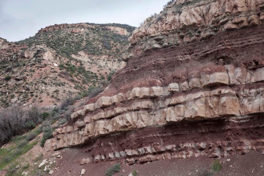
Edge of Cedar Mesa, Utah. The cliffs consist of resistant sandstone whereas the slopes are made of less resistant shale and siltstone.
Below is another example of how the resistant cliffs tend to erode by rock fall.
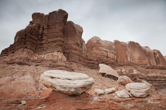
Sandstone blocks, fallen from the cliffs above, onto slopes of less resistant shale and siltstone, Utah.
In places where the rocks are tilted, the more resistant rocks form ridges whereas the less resistant ones form valleys. In places where the rock is folded, these ridges and valleys curve in the same way as the rocks. Importantly, bedding takes on an important role in erosion of tilted rocks, as it encourages sliding of rock in the direction of tilt. As a result, the ridges are typically asymmetric: they slope parallel to bedding on one side to create a “dip slope”, and form ledges and cliffs on the opposite side.
Tilted resistant sandstone forms asymmetric ridge with dip-slope (on the left). Colorado.
The photo below shows numerous ridges held up by resistant sedimentary rock with intervening “strike” valleys eroded into less-resistant rock. The rocks dip steeply to the right (east).

Aerial view of resistant hogback ridges and strike valleys near Mora, New Mexico.
Lava flows and metamorphic rocks exhibit layering that can influence topography in a similar way, although in these rocks, the extent of the layering tends to be more local and less predictable. The widespread lava flows of late-Cenozoic age in the western US have probably the biggest effect on the landscape. Many of these flows are relatively undeformed and so remain approximately flat-lying. Similar to sedimentary sequences, they form large plateaus that in places are incised by deep canyons. Examples of these flows include the basalt flows of the Snake River Plain in Idaho and the basalt flows of the Columbia Plateau in Oregon and Washington.

Flat-lying Lava Flows of Columbia River Basalt Group, Washington
So landscapes are shaped by erosion, but the erosion depends on the weathering processes at hand and the rock type and structure. The weathering processes allow erosion to proceed and the rock type and structure guide both the weathering and erosion. The lead-off photo in this post shows canyons in the meandering Green River. It looks that way because the rocks are flat-lying. The stair-stepped topography down to the river, of cliffs and slopes, simply results from alternating resistant and less-resistant rock types. And the river? It’s entrenched in the canyons, probably because it continued to downcut as the region uplifted.
Here’s another example –another aerial from the Colorado Plateau –you can see how flat-lying rocks create the stair-stepped topography down to the river –and the uppermost resistant rock forms a nearly flat upland.
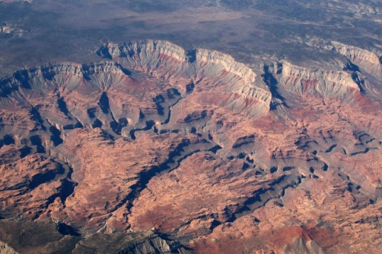
Stair-stepped topography and entrenched meanders, northern Arizona.
Yay!
For more images of weathering and erosion, all freely downloadable, please check out my gallery of weathering and erosion photos –or go to the keyword search on my website and type in “weathering” or “erosion” –or both!

This is the best explanation I’ve ever seen of differential erosion & the different types of erosion. And the photos are really great illustrations of your textual explanations. For those of us who live on the forested side of the Cascades, seeing the geology exposed in more arid regions is a great help in understanding these geologic processes. Thanks again!
LikeLiked by 1 person
Thank you for the wonderful comment Wes!
LikeLike
Reblogged this on Primate's Progress and commented:
Landscape as process, beautifully illustrated. Students with Marli Miller as instructor are fortunate indeed
LikeLiked by 1 person
Thank you Paul! And thanks for re-posting!
LikeLike
Great examples and explanations, Marli!
LikeLike
Thank you!
LikeLike
Pingback: Seeing some cool properties of water through the lens of its molecular structure | geologictimepics
Pingback: Rock Carvings – Shaping Landscapes – Dr. Roseanne Chambers
thanks for the link, Roseanne!
LikeLike
very crisp and clear description. thanks Marli Miller.
LikeLike