Geologic Irony in Cincinnati and northern Kentucky! Deep geologic time everywhere –and the absurd denial of the Creation Museum.
It’s been awhile since I’ve posted –too many things have been happening, like the end of fall term, other deadlines, and of course, coming down with a bad cold! But I did manage to visit Cincinnati, Ohio for Thanksgiving. I’m originally from Cincinnati, and I always enjoy going back.

Ordovician shale and limestone along I-75 in northern Kentucky; downtown Cincinnati, Ohio occupies the background
Besides visiting with old friends, one thing I love about the Cincinnati-Northern Kentucky area, is the incredible wealth of marine fossils in its rocks, which date from the Ordovician Period, some 475 million years ago. It’s always amazing to me that I can, almost at random, pick up a rock and see the remains of critters that were actually alive so long ago. It fills me with a sense of wonder, mystery, and awe that I’ll never be able to explain –and it demonstrates to me how I’m a part of the earth –not apart from it.

marine fossils in Ordovician limestone from northern Kentucky –you can see mostly brachipods (they look sort of like clam shells) and bryozoa (branching coral-like things) in this rock.
Really, these fossil-rich limestones are just about EVERYWHERE! Even many of the stone buildings and walls that you can see throughout Cincinnati, are full of Ordovician marine fossils.
And what a wonderful setting! The Ohio river cuts through its original floodplain, now perched a couple hundred feet above the river. That’s actually a whole story in itself, because today’s Ohio River formed as a result of the continental ice sheet advancing across northern Ohio, and blocking the courses of several north-flowing rivers, such as the Kentucky and Licking Rivers.

Looking up the Ohio River from the air –near where Ohio, Kentucky, and Indiana meet.
And then there’s the Creation Museum in northern Kentucky, perched on the old river terrace above bedrock of fossil-rich Ordovician limestone and shale. One look at the two photos below and you can see what they’re all about.

The explanation for fossils according to the Creation Museum (on the left), and a diorama (on the right) depicting a human being coexisting with a dinosaur.
According to “The Museum”, fossils “were formed by Noah’s Flood (~4,350 years ago) and its aftermath” –and dinosaurs really did coexist with humans. In fact, I read that before Adam and Eve ate their apple, T Rex dinosaurs were actually vegetarian.
But don’t take it from me that those limestones are actually very old (100s of millions of years, as opposed to 4,350 years). Take a look at a geologic map. The Cincinnati-Northern Kentucky area is underlain by more than 1000 feet of limestone and shale –and if you travel eastward or westward, you encounter 1000’s more feet of marine sedimentary rock that sit on top the Ordovician. And the fossils in those rocks show a change with time, called evolution. If you think about it, you’re looking at a long long time to deposit –and preserve–all that sediment.

Geologic map of the United States; the area around Cincinnati is enlarged. “CM” shows the approximate location of the Creation Museum.
The Creation Museum tells us that all that sediment was deposited by “the flood”. Never mind that very little of the rock contains particles even as big as a sand grain. Below is a photo of a real flood deposit. As you can see, the deposit is very coarse-grained! It’s coarse-grained because large floods are very energetic and transport large particles.

Coarse-grained sediment, deposited by one of the Missoula Floods in Oregon, some 15,000 years ago. The exposure is about 20 feet high.
So the Creation Museum is asking you to BELIEVE that 1000s of feet of limestone were deposited by a flood, as well as the 1000s of feet of older rocks and 1000s of feet of younger rocks I didn’t even mention. They also want you to believe that T. Rex was a vegetarian who lived alongside Adam and Eve.
But here’s what really bothers me: by misrepresenting science and promoting its own skewed interpretation of the bible as the literal Truth, the “museum” discourages people from looking at these beautiful rocks with a sense of wonder, mystery, and awe. It discourages them from inquiring into how those rocks really formed. The museum discourages people from learning important things about our planet and from forming their own views on the world.
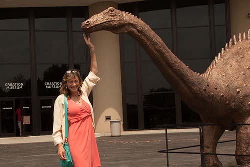
Me petting a dinosaur at the Creation Museum.
Type “Ordovician” into the search for a few more photos of Ordovician fossils.