geologictimepics

Geology and Geologic Time through Photographs

Archive for the tag “Angular unconformity”

Grand Canyon Unconformities –and a Cambrian Island

A prominent ledge punctuates the landscape towards the bottom of the Grand Canyon. It’s the Tapeats Sandstone, deposited during the Cambrian Period about 520 million years ago, when the ocean was beginning to encroach on the North American continent, an event called the Cambrian Transgression. Above the ledge, you can see more than 3000 feet of near-horizontal sedimentary rocks, eroded into cliffs and slopes depending on their ability to withstand weathering and erosion. These rocks, deposited during the rest of the Paleozoic Era, are often used to demonstrate the vastness of geologic time–some 300 million years of it.

View of the Grand Canyon from the South Rim trail. Arrows point to the Cambrian Tapeats Sandstone.

View of the Grand Canyon from the South Rim trail. Arrows point to the Tapeats Sandstone.

But the razor-thin surface between the Tapeats and the underlying Proterozoic-age rock reflects the passage of far more geologic time  –about 600 million years where the Tapeats sits on top of the sedimentary rocks of the Grand Canyon Supergroup. Those rocks are easy to spot on the photo above because they contain the bright red rock called the Hakatai Shale. Even more time passed across the surface where the Tapeats sits on top of the 1.7 billion year old metamorphic basement rock. You can put your thumb on the basement and a finger on the Tapeats –and your hand will span 1.2 billion years! Read more…

Geologic history of the western United States in a cliff face in Death Valley National Park

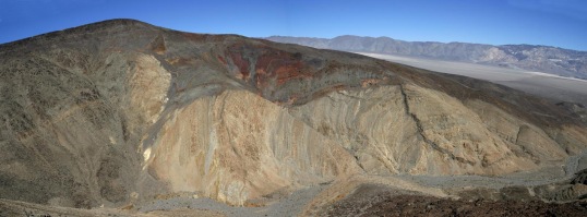
Of the many geologic events that shaped the western United States since the beginning of the Paleozoic Era, five really stand out.  In approximate chronological order, these events include the accumulation of tens of thousands of feet of sedimentary rock on a passive margin, periods of compressional mountain building that folded and faulted those rocks during much of the Mesozoic–likely driven by the accretion of terranes, intrusion of subduction-related granitic rock (such as the Sierra Nevada) during the Jurassic and Cretaceous, volcanic activity during the late Cenozoic, and mountain-building by crustal extension during the late Cenozoic and continuing today.  This photo on the western edge of Panamint Valley in Death Valley National Park of California, captures all five.

View of canyon wall on west side of Panamint Valley in SE California --part of Death Valley National Park.  See photo below for interpretation.

View of canyon wall on west side of Panamint Valley in SE California –part of Death Valley National Park. See photo below for interpretation.

The photograph below shows an interpretation.  Paleozoic rock is folded because of the Late Paleozoic-early Mesozoic compressional mountain-building; it’s intruded by Jurassic age granitic rock, an early phase of Sierran magmatism that took place just to the west; the granitic rock is overlain by Late Cenozoic basalt flows, and everything is cut by a normal (extensional) fault.  And there is also a dike that cuts the Paleozoic rock –probably a feeder for the basalt flows.

Interpretation of top photo.

Interpretation of top photo.

So this is all nerdy geology cross-cutting relations talk –but here’s the point: in this one place, you can see evidence for 100s of millions of years of Earth History.  Earth is old old old!  THAT’S why I love geology!

And for those of you who crave geologic contacts?  This photo has all three: depositional, between the basalt and underlying rock; intrusive, between the Mesozoic granite and the folded Paleozoic rock; fault, the steeply dipping black line between the basalt and the Paleozoic rock.  Another reason why I love geology!


click here to see photos and explanations of geologic contacts.
or click here for a slideshow of Death Valley geology.

Cambrian rock

–the last posting, (March 21) had a photo of granite of the Cretaceous Sierra Nevada Batholith intruding Cambrian sedimentary (now metamorphosed) rocks.  These photos show more Cambrian rock.  The Cambrian Period (542-488 million years ago) is the bottom of the Phanerozoic Eon –and one reason Cambrian rocks are significant, is that they are the oldest rocks to contain shelly fossils.  Older rocks, called “Precambrian” may contain fossil impressions or fossilized algae, but don’t contain any shells.

At the risk of being too repetitive (see post March 13) the upper photo shows Cambrian limestone in the Death Valley region –there are thousands of feet of Cambrian Limestone in the Death Valley region.   The lower photo shows Cambrian sandstone, shale, and limestone overlying tilted Precambrian sedimentary rock in the Grand Canyon.

My point is that the Cambrian section is traceable over great distances.  That’s important, because the base of the Cambrian provides a common datum over much of the western US –certainly from the Sierra Nevada to Death Valley to the Grand Canyon –but in later posts, you can see that it’s also in Colorado, Wyoming, Montana… and so on!

Cambrian limestone in the Nopah Range, SE Californi

Thousands of feet of marine limestone make up many of the mountain ranges in the Death Valley area of SE California. Click here to see a geologic map of Death Valley National Park...

The photo above shows the Cambrian Bonanza King Formation (gray) on top the Cambrian Carrara Fm (orange).

And the photo below shows the near-horizontal Cambrian and younger rocks of the Grand Canyon over tilted Precambrian sedimentary rock.  It’s really thin here… the Cambrian only goes up through the arrow.

Post Navigation