geologictimepics

Geology and Geologic Time through Photographs

Archive for the category “photography”

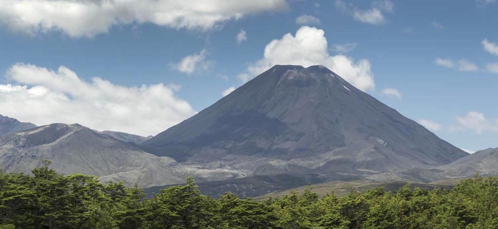
Summarizing Death Valley’s Geology in 12 outtake photos

I’ve long been drawn to Death Valley. As a geologist, I can’t think of a better place to witness the incredible geologic history that shaped western North America –and as a photographer, I can’t think of a better place to capture images of what’s a mind-boggling array of geologic features.

To that end, I recently completed a book called Death Valley Rocks! A guide to geologic sites in America’s hottest national park. It’s being published by Mountain Press and should be out in early July. The book covers 40 geologically amazing sites in the national park as well as the adjacent Amargosa Valley and will be full of color photos and maps –and (of course) many of my photos didn’t make the cut. Here are twelve of those outtakes, selected to present a general picture of Death Valley’s geology. You can click on any image to see it at a larger size.

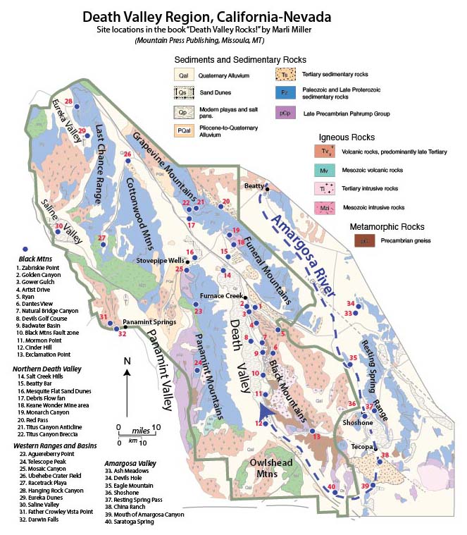
The first photos reflect Death Valley’s modern setting, an actively evolving basin in the southwestern part of the Basin and Range Province. The valley is the terminus of the Amargosa River, shown as the heavy dashed blue line resembling a giant fishhook in the map. The river starts just north of Beatty, Nevada, and flows southward about a 100 miles through the towns of Shoshone and Tecopa before turning northward to empty into Death Valley. Without an outlet, all the water that reaches the floor of Death Valley stays there until it evaporates. As it evaporates, the water precipitates salt, producing a magnificent salt pan that is broken by myriad polygonal shrinkage cracks.

Read more…

“Oregon Rocks!” My new book about Oregon’s Wonderful Geology

I’m very happy to announce that my new book, Oregon Rocks! A guide to 60 Amazing Geologic Sites, is out there and available. Although the title always makes me cringe a little, I’m excited and proud of this project, which took me three years to complete and took me all over my beautiful state. At the risk of being overly exuberant, here are some excerpts!

If you click on the image below, you can actually read the table of contents (left) and study the site map. Both these illustrations group the sites in one of Oregon’s six physiographic provinces: The Coast Range, Klamath Mountains, Cascade Range, Lava Plateaus, Blue Mountains, and Basin and Range.

Table of contents and site map of Oregon Rocks!

The site numbers are especially important –not only because they key to the map location and page numbers in the book –they also refer to the timeline and schematic cross-section across the state. I’m especially proud of this part because it lets you place each site into the context of how the entire region evolved. Click on the timeline and maps below to see what I mean!

Read more…

Countertop Geology: Desperate for rocks? Visit a “granite” countertop store!

Where can you see some rocks? It’s winter and everything’s covered in snow –or you’re visiting family in some place where there’s virtually no bedrock exposed anywhere –or you’re simply stranded far from any good rocks in the center of a big city.IP18-0957c

Take yourself on a field trip to a granite countertop store! You might not see very much real granite, but you will see some other types: folded gneiss, pegmatite, amphibolite, quartzite, maybe even some granite… and a lot of amazing metamorphic and igneous features and faults –and they’re all polished and none are covered by vegetation.

I needed a rock fix the other day while visiting my mother in SW Florida –so I drove to a granite countertop store. And wow— I saw all sorts of great stuff, a lot of which related to faulting and fracturing, and a lot of it could go right into a geology textbook. In Florida!

IP18-0947e

Red garnet along with quartz and feldspar in gneiss -a metamorphic rock.

Read more…

Iceland –where you can walk a mid-Atlantic rift –and some other geology photos

While Iceland hosts an amazing variety of awesome landscapes, what stands out to me most are its incredible exposures of the Mid-Atlantic ridge. To the north and south, the ridge lies beneath some 2500m of water, forming a rift that separates the North American plate from the Eurasian plate. The rift spreads apart at a rate of some 2.5 cm/year, forming new oceanic lithosphere in the process. But in Iceland, you can actually walk around in it!

Please click on any of the images below to see them enlarged.

Iceland2geomapplates

Geologic map of Iceland as compiled from references listed below.

Read more…

Hug Point State Park, Oregon, USA –sea cliffs expose a Miocene delta invaded by lava flows

180728-124

Alcove and tidepool at Hug Point

Imagine, some 15 million years ago, basaltic lava flows pouring down a river valley to the coast –and then somehow invading downwards into the sandy sediments of its delta. Today, you can see evidence for these events in the sea cliffs near Hug Point in Oregon. There, numerous basalt dikes and sills invade awesome sandstone exposures of the Astoria Formation, some of which exhibit highly contorted bedding, likely caused by the invading lava. It’s also really beautiful, with numerous alcoves and small sea caves to explore. And at low to medium-low tides, you can walk miles along the sandy beach!

(Click on any of the images to see them at a larger size)

Read more…

Devil’s Punchbowl –Awesome geology on a beautiful Oregon beach

You could teach a geology course at Devil’s Punchbowl, a state park just north of Newport, Oregon. Along this half-mile stretch of beach and rocky tidepools, you see tilted sedimentary rocks, normal faults, an angular unconformity beneath an uplifted marine terrace, invasive lava flows, and of course amazing erosional features typical of Oregon’s spectacular coastline. And every one of these features tells a story. You can click on any of the images below to see them at a larger size.

180629-46ce

View southward from Cape Foulweather to the Devil’s Punchbowl.


180629-58ceThe rocks. They’re mostly shallow marine sandstones of the Astoria Formation, deposited in the early part of the Miocene, between about 16.5 to 22 million years ago. The rocks are tilted so you can walk horizontally into younger ones, which tend to be finer grained and more thinly bedded than the rocks below. This change in grain size suggests a gradual deepening of the water level through time. In many places, you can find small deposits of broken clam shells, likely stirred up and scattered during storms –and on the southern edge of the first headland north of the Punchbowl, you can find some spectacular soft-sediment deformation, probably brought on by submarine slumping. Later rock alteration from circulating hot groundwater caused iron sulfide minerals to crystallize within some of the sandstone. Read more…

Grand Canyon Unconformities –and a Cambrian Island

A prominent ledge punctuates the landscape towards the bottom of the Grand Canyon. It’s the Tapeats Sandstone, deposited during the Cambrian Period about 520 million years ago, when the ocean was beginning to encroach on the North American continent, an event called the Cambrian Transgression. Above the ledge, you can see more than 3000 feet of near-horizontal sedimentary rocks, eroded into cliffs and slopes depending on their ability to withstand weathering and erosion. These rocks, deposited during the rest of the Paleozoic Era, are often used to demonstrate the vastness of geologic time–some 300 million years of it.

View of the Grand Canyon from the South Rim trail. Arrows point to the Cambrian Tapeats Sandstone.

View of the Grand Canyon from the South Rim trail. Arrows point to the Tapeats Sandstone.

But the razor-thin surface between the Tapeats and the underlying Proterozoic-age rock reflects the passage of far more geologic time  –about 600 million years where the Tapeats sits on top of the sedimentary rocks of the Grand Canyon Supergroup. Those rocks are easy to spot on the photo above because they contain the bright red rock called the Hakatai Shale. Even more time passed across the surface where the Tapeats sits on top of the 1.7 billion year old metamorphic basement rock. You can put your thumb on the basement and a finger on the Tapeats –and your hand will span 1.2 billion years! Read more…

Sampling New Zealand’s (Amazing) Geology

New Zealand’s landscape can make just about anybody appreciate geology. Its glaciated peaks, its coastline –that ranges from ragged cliffs to sandy beaches to glacial fjords– its active volcanoes… they all work together to shout “Earth Science!” With that in mind, here’s some basics of New Zealand’s amazing geology, followed by some geological highlights of my trip of January and early February, 2018.

NZ map--all

Map of New Zealand, showing accreted terranes in colors and cover assemblage in gray. (Compiled mostly from Graham, 2015)

North and South Island Bedrock  The different colors on this map show New Zealand’s basement rock, named so because it forms the lowest known bedrock foundation of any given area. The basement tells stories of New Zealand’s deep past, from about 500-100 million years ago. Individual colors signify different terranes, accreted (added) one-by-one through plate motions to the edge of what was then the supercontinent Gondwana. They mostly consist of sedimentary and metamorphosed sedimentary rock, although the narrow belt of purple-colored Dun Mountain Ophiolite formed as oceanic lithosphere, and the red-colored areas consist of granitic igneous rock, some of which has been metamorphosed to gneiss.

Gray indicates the younger cover rock, formed after accretion of the terranes. Consisting of a wide range of sedimentary and volcanic rocks, as well as recently deposited sediment, it’s just as interesting and variable as the terranes. Because it includes volcanoes, it’s largely the cover that gives the North Island its distinctive flair. By contrast, the South Island consists largely of uplifted basement rock, much of which has been –and still is—glaciated. All those long deep lakes, such as Lakes Wanaka and Tekapo, were carved by glaciers and are now floored with their deposits of till.

Andesite stratovolcano, New Zealand

Mt. Ngauruhoe, a 7000 year-old andesite stratocone near Ruapehu on the North Island

Those differences exist largely because the North and South Islands occupy different plate tectonic settings. The North Island sits over a subduction zone, so it hosts an active Read more…

Cove Palisades, Oregon: a tidy short story in the vastness of time

If I were a water skier, I’d go to Lake Billy Chinook at Cove Palisades where I could ski and see amazing geology at the same time. On the other hand, I’d probably keep crashing because the geology is so dramatic! Maybe a canoe would be better.

Lake Billy Chinook, Oregon

View across the Crooked River Arm of Lake Billy Chinook to some of the 1.2 million year old canyon-filling basalt (right) and Deschutes Fm (left). The cliff on the far left of the photo is also part of the 1.2 million year basalt.

The lake itself fills canyons of the Crooked, Deschutes and Metolius Rivers. It backs up behind Round Butte Dam, which blocks the river channel just down from where the rivers merge. The rocks here tell a story of earlier river canyons that occupied the same places as today’s Crooked and Deschutes Rivers. These older canyons were filled by basaltic lava flows that now line some of the walls of today’s canyons.

CovePalisades2
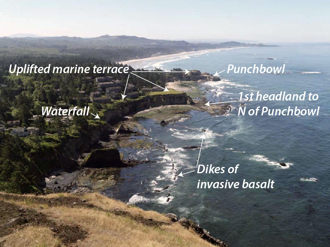
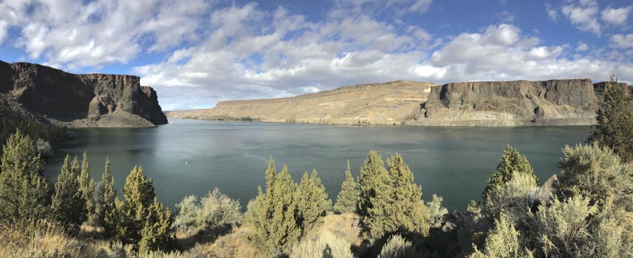
From the geologic map, modified from Bishop and Smith, 1990, you can see how the brown-colored canyon-filling basalt, (called the “Intracanyon Basalt”) forms narrow outcrops within today’s Crooked and Deschutes canyon areas. It erupted about 1.2 million years ago and flowed from a vent about 60 miles to the south. You can also see that most of the bedrock (in shades of green) consists of the Deschutes Formation, and that there are a lot of landslides along the canyon sides.

The cross-section at the bottom of the map shows the view along a west-to-east line. Multiple flows of the intracanyon basalt filled the canyon 1.2 million years ago –and since then the river has re-established its channel pretty much in the old canyon. While the map and cross-section views suggest the flows moved down narrow valleys or canyons, you can actually see the canyon edges, several of which are visible right from the road.

Read more…

Mauna Loa Volcano, Hawai’i –Earth’s largest active volcano

To get an idea of the immensity of Mauna Loa Volcano, take a look at the photo below. That rounded shape continues from its summit area at 13,678 feet above sea level to about 18,000 feet below sea level –and then another 25,000 feet or so below that because the mountain has sunk into the oceanic crust. It’s unquestionably the world’s largest active volcano.

Mauna Loa Shield Volcano

Profile of Mauna Loa Shield Volcano from… Mauna Loa Shield Volcano! (Geologypics: (170919s-15))

Briefly, Mauna Loa’s made of basalt. Basaltic lava flows, being comparatively low in silica, have low viscosities and so cannot maintain steep slopes, resulting in broad, relatively low gradient volcanoes called shields. With just a little imagination, you can see how Mauna Loa’s shape resembles that back side of some shield one of King Arthur’s Knights might carry into battle.

Read more…

Post Navigation