I’ve long been drawn to Death Valley. As a geologist, I can’t think of a better place to witness the incredible geologic history that shaped western North America –and as a photographer, I can’t think of a better place to capture images of what’s a mind-boggling array of geologic features.
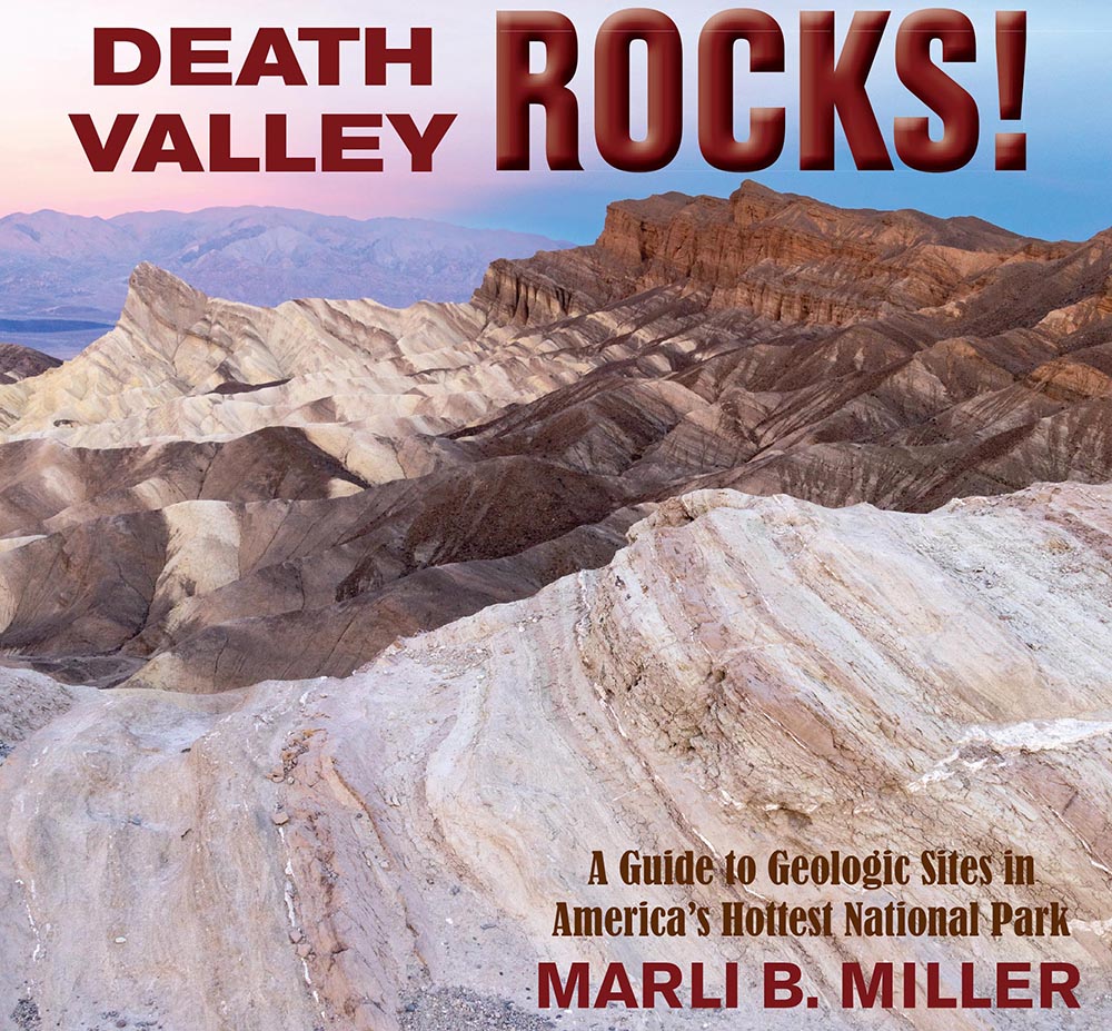
To that end, I recently completed a book called Death Valley Rocks! A guide to geologic sites in America’s hottest national park. It’s being published by Mountain Press and should be out in early July. The book covers 40 geologically amazing sites in the national park as well as the adjacent Amargosa Valley and will be full of color photos and maps –and (of course) many of my photos didn’t make the cut. Here are twelve of those outtakes, selected to present a general picture of Death Valley’s geology. You can click on any image to see it at a larger size.
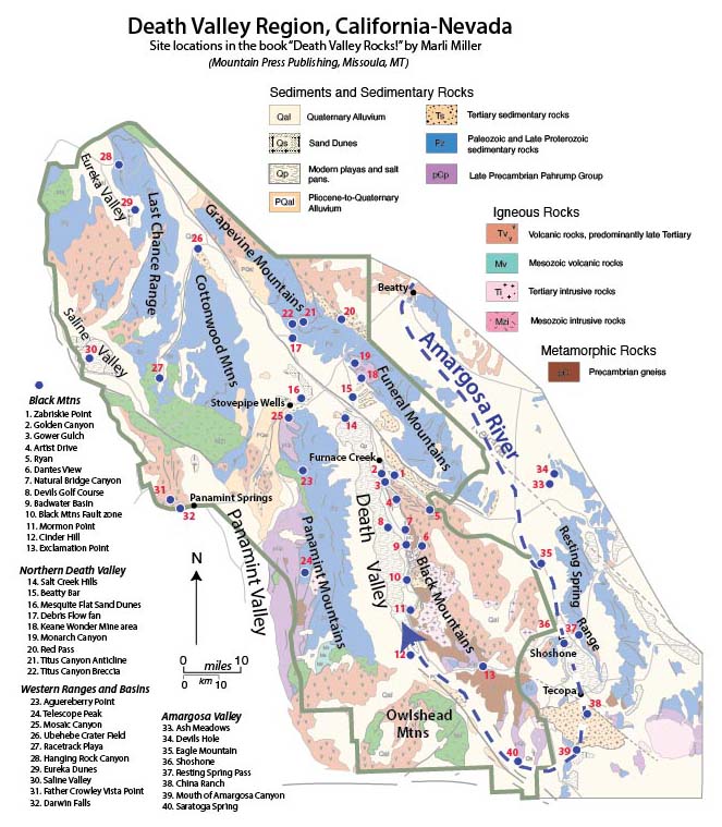
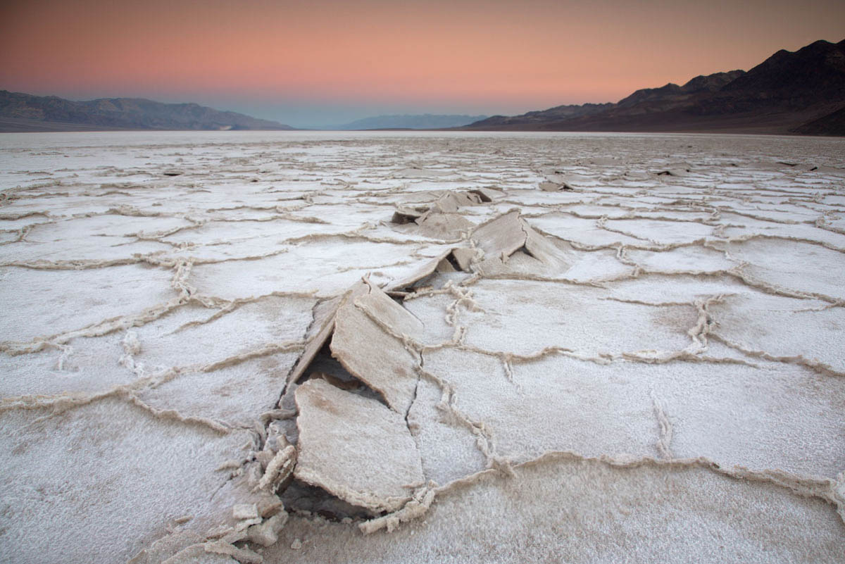
The first photos reflect Death Valley’s modern setting, an actively evolving basin in the southwestern part of the Basin and Range Province. The valley is the terminus of the Amargosa River, shown as the heavy dashed blue line resembling a giant fishhook in the map. The river starts just north of Beatty, Nevada, and flows southward about a 100 miles through the towns of Shoshone and Tecopa before turning northward to empty into Death Valley. Without an outlet, all the water that reaches the floor of Death Valley stays there until it evaporates. As it evaporates, the water precipitates salt, producing a magnificent salt pan that is broken by myriad polygonal shrinkage cracks.
I’m hiking up a closed road in Death Valley National Park to see a pile of gravel. I guess that’s one way to look at it. What some folks might view as a waste of precious time in this magnificent place I see as a vehicle for time travel.
Gravel ridge along the Beatty cut-off road in Death Valley was deposited as a spit near the shoreline of Glacial Lake Manly. The highway cuts right through the center of the spit.Two smaller spits are visible on the far right side of the image. (photo 240106-97)
Just 4 months ago in August, Hurricane Hilary dropped some 2.2 inches of rain on Death Valley—more than what typically falls here over the course of a year. With virtually no soil to absorb it, the water ran off immediately. It gathered in rivulets, confluenced into small channels, then larger channels, and finally streams that flash-flooded down canyons and alluvial fans. The flooding closed every road in the national park. It’s now early January, 2024 and this road up one of the fans isn’t supposed to open to cars for another two weeks.
In just under two miles, I reach my destination, a low ridge extending eastward from the base of a hill. It was deposited by waves near the shoreline of a giant lake called Glacial Lake Manly, sometime between186,000-120,000 years ago. The ridge grew by fits and starts out from the hill as a spit, with waves obliquely slapping its front and moving the gravel out to its tip. You can see wave-rounded cobbles in the roadcut forming curved layers that slope towards the valley. They’re also scattered about on the top of the spit where I sit down and take in the view.
The highway cuts right through the spit. Death Valley, once filled to a spot above and behind the spit, is in the background.(Photo 191101-75)
In front of me, the highway descends its gentle gradient to where I parked the car, nearly 200’ below sea level. From there, the floor of Death Valley is practically flat, continuing well past Badwater Basin some 25 miles to the south. When this gravel spit formed, Lake Manly, more than 50 miles in length and some 6-8 miles wide, filled the entire scene. At its high stand, I’d be below water because the lake’s highest shoreline reached another mile up the road. The gravel spit formed as the lake receded. Two smaller ridges lie just below where I sit and another very small one lies just above, marking different stages in its retreat.
Just like anybody, I wrestle with the ever-changing and fluid concept of time. Stopped highway traffic that delays my arrival by 15 minutes can seem interminable and I bemoan how quickly a year passes. I’ve heard countless people comment at how Badwater Basin is still flooded by water from Hurricane Hilary but when it all finally evaporates, we’ll probably describe the shallow lake as short-lived. This remnant of a giant lake that existed over 100,000 years ago takes my confusion to a new level. Was that a long time ago?
It seems so, but then I think of the mountains that enclosed the lake. They started rising some 3-3.5 million years ago—more than 20 times the age of the lake. I’ve always considered the mountains to be young, even going so far as to tell park visitors that Death Valley’s present landscape was “only about 3 million years old”. Compared to their rocks, many of which are older than 500 million years, that’s true. Some of the rocks are well over a billion years old.
Those rocks tell stories –about how they formed and about what’s happened to them since. I pick a cobble up off the spit. It’s a beautiful maroon color and made of tiny grains of quartz all mushed together. I suspect it came from the Zabriskie Quartzite, a distinctive rock unit that forms prominent cliffs throughout the region. Its sand was deposited mostly in a shallow ocean and various coastal environments during the Cambrian Period, which lasted from 539-485 million years ago.
Overturned Anticline in Titus Canyon–the Zabriskie Quartzite forms the prominent red cliffs in the right-center of the photo. To the left (west) is overturned Cararra and Bonanza King Formations. At the canyon mouth, the rocks are nearly horizontal, yet upside down. (Photo SrD-10)
I’ve studied geology my entire adult life and I still find it incredible that I can hold, in my own hands, a piece of the Cambrian sea floor. Each of the millions of tiny sand grains that make up this rock originated from some still-older rock and were transported by streams to the Cambrian shoreline. There, they were probably kicked around by coastal waves until getting buried by layers of more sediment, followed by more sediment for who knows how long –until circulating groundwater cemented the compacted grains together as layers of rock. In the Death Valley region, there are more than 10,000 feet of sedimentary rock on top the Zabriskie Quartzite and at least another 10,000 feet of sedimentary rock below. Each bedding plane in that sequence of rock was once the Earth’s surface.
And so much has happened to them since! Besides today’s mountain-building, driven because the earth’s crust in the region is extending, they’ve all experienced an earlier period of mountain-building by crustal compression. At the mouth of Titus Canyon just 20 miles northwest of here, those events folded the rock to where the sequence is completely upside down. Elsewhere, the rocks were intruded by granitic magma, while others were carried to depths of 15 miles or more and partially melted. And now, as today’s mountains erode, they shed rocks of all ages and types and sizes into their canyons, which get washed out onto the alluvial fans during floods.
From my perch on the gravel spit, I’m just a few feet above the alluvial fan. It’s unmoving and silent. The road will reopen soon, and tourists will once again drive past this spot without a second thought. But the myriad channels and wild assortment of rocks of the fan speak to a process that never stops. It will flood again. I see the whole fan in motion, with gravel streaming over the road, tearing up the asphalt, eventually burying or eroding the gravel spit. Today, this year, my existence—they all seem to diminish into the infinitesimal. I close my eyes and start walking downhill, deeper into the lake.
This essay came about from researching my forthcoming book: Death Valley Rocks! Forty amazing geologic sites in America’s hottest National Park, to be published by Mountain Press. (Sept, 2024)
Each photo (and >5000 more) is available for free download from my photography site, geologypics.com –just type the description or stock number into the search.
A trip to Death Valley over Thanksgiving two weeks ago reignited all sorts of things in my brain, one of which being my love of conglomerate. Honestly, conglomerate HAS to be the coolest rock!
Tilted conglomerate in Furnace Creek Wash, Death Valley.
Just look at this stuff! Just like any good clastic sedimentary rock, it consists of particles of older rock–but with conglomerate, you can easily see those particles. Each of those particles opens a different door to experiencing deep geologic time.
As an example, look at the conglomerate below, from the Kootenai Formation of SW Montana. It contains many different cobbles of light gray and dark gray quartzite and pebbles of black chert. The quartzite came the Quadrant Formation and chert from the Phosphoria Formation. So just at first glance, you can see that this conglomerate in the Kootenai contains actual pieces of two other older rock units.
Conglomerate of the Kootenai Formation, SW Montana.
But consider this: The Quadrant formed as coastal sand dunes during the Pennsylvanian Period, between about 320-300 million years ago and the Phosphoria chert accumulated in a deep marine environment during the Permian, from about 300-250 million years ago. The Kootenai formed as river deposits during the early part of the Cretaceous Period, about 120 million years ago. All those are now together as one.
Similar to the modern river below (except for the glaciers), the Kootenai rivers transported gravel away from highlands –the highlands being made of much older rock that was uplifted and exposed to erosion. That older rock speaks to long gone periods of Earth history while the gravel speaks to the day it’s deposited.
Athabasca River in Jasper National Park, Alberta
But this is where my head starts to spin: the modern gravel is made of rounded fragments of old rock –so when you look at a conglomerate, you glimpse at least two time periods at once: you see the conglomerate, which reflects a river or alluvial fan –or any environment near a bedrock source– and you also see the particles, which formed in even older environments.
And it gets worse –or better. What happens when you see a conglomerate eroding? The conglomerate is breaking up into modern sediment, which consists of pieces of older sediment –that at one time was modern sediment that used to be older sediment? Look at the pebbles below. I keep them in a rusty metal camping cup on a table in my office.
“Recycled” pebbles of the Kootenai Formation.
These stream pebbles eroded out of the Kootenai conglomerate. So… they’re simultaneously modern stream pebbles and ancient ones –AND… they originated as the Quadrant and Phosphoria Formations. Four periods of time, spanning 300 million years, all come together at once.
And if that’s not enough, those conglomerates in Death Valley? They contain particles of… conglomerate! Look! The arrow in the left photo points to the boulder of conglomerate on the right. If you click on the photos, you can see them enlarged.
Conglomerate in Furnace Creek Wash. Arrow points to conglomerate boulder (right)
All those particles, which are now eroding and becoming modern sediment, were yesterday’s sediment. And the conglomerate boulder? It too is becoming “modern sediment” and it too was “yesterday’s sediment” when it was deposited on an alluvial fan with the rest of the material. However, it goes a step further: its pebbles and cobbles were both “modern” and “yesterday’s” sediment at a still older time. And before that? Those pebbles and cobbles eroded from even older rock units, some of which date from the Cambrian, about 500 million years ago.
For fun, here’s a photo of another conglomerate boulder.
Conglomerate boulder in conglomerate of the Furnace Creek Formation, Death Valley, CA.
I can’t help but wonder how Young Earth Creationists would deal with these rocks. Given their story of the Grand Canyon, in which the Paleozoic section was deposited during early stages of “The Flood” and the canyon was carved during the later stages (they really do say that too!), they’d probably roll out that same blanket answer: The Flood. End of discussion. No questioning, no wondering.
In my opinion, one of the beautiful things about geology is that we’re always questioning and wondering.
Death Valley… I can’t wait! Tomorrow this time, I’ll be walking on the salt pan with my structural geology students, gawking at the incredible mountain front –and soon after that, we’ll be immersed in fault zones, fractures, and fabrics!
Death Valley salt pan at sunrise.
Death Valley presents incredible opportunities for all sorts of geology, especially geologic time; you can look just about anywhere to see and feel it. Take the salt pan. It really is salt –you can sprinkle it on your sandwich if you want. It’s there because the valley floor periodically floods with rainwater. As the rainwater evaporates, dissolved salt in the water precipitates. And between 186,000-120,000 years ago, Death Valley was filled by a 600′ deep lake, which evaporated, leaving behind more salt. Before that, more shallow flooding and more lakes.
Aerial view of faulted front of the Black Mountains.
But the basin is more than 4 miles deep in some places! It’s not all salt, because there are a lot of gravel and sand deposits, but a lot of it is salt. That depth speaks to geologically fast accumulation rates, because it all had to accumulate since Death Valley formed –probably in the last 2 or 3 million years. But still, 2 or 3 million years is way past our realm of experience.
Hiker in the Funeral Mountains of Death Valley.
To really go back in geologic time though, you need to look at the mountains. Most of the mountains contain Upper Precambrian through Paleozoic sedimentary rock, most of which accumulated in shallow marine environments. There’s a thickness of more than 30,000 feet of sedimentary rock exposed in Death Valley! Deposited layer after layer, you can only imagine how long that took.
We can measure the thickness of the rock because it’s no longer in its original horizontal position. The ones in the photo above were tilted by faulting –which occurred during the period of crustal extension that formed Death Valley today. The rocks in the photo below were folded –by a period of crustal shortening that took place long before the modern extension. The folding occurred during the Mesozoic Era –more than 65 million years ago.
Aerial view of Titus Canyon Anticline.
Above the Upper Precambrian to Paleozoic rock are thousands of feet of volcanic and sedimentary rock, tilted and faulted, but not folded. They reveal many of the details of the crustal extension that eventually formed today’s landscape. For example, the photo below shows Ryan Mesa in upper Furnace Creek Wash. In this place, the main period of extensional faulting predates the formation of modern Death Valley. Look at the photo to see that faulting must have stopped before eruption of the dark-colored basalt flows. Notice that there has to be a fault underneath the talus cones that separates the Artist Dr. Formation on the left from the Furnace Creek Formation on the right. Because the fault does not cut the basalt though, it has to be older. Those basalts are 4 million years old, older than modern Death Valley. –And that’s the old mining camp of Ryan perched on the talus.
Angular unconformity at Ryan Mesa: 4 Ma basalt flows overlying faulted Artist Drive (left) and Furnace Creek (right) formations.
And beneath it all? Still older rock! There’s some 5,000 feet of even older Precambrian sedimentary rock, called the “Pahrump Group” beneath the 30,000 feet of Upper Precambrian and Paleozoic rock–and below that, Precambrian metamorphic rock. It’s called the “basement complex” because it’s the lowest stuff. Here’s a photo.
pegmatite dike and sill intruding gneiss
The pegmatite (the light-colored intrusive rock) is actually quite young–I think our U-Pb age was 55 Ma –but the gneiss is much older, with a U-Pb age of 1.7 billion years. Billion! Forget about the U-Pb age though. These rocks form miles beneath Earth’s surface –and here they are, at the surface for us to see. Without knowing their age, you’re looking at deep geologic time because of the long period of uplift and erosion required to bring them to the surface. And it happened before all those other events that described earlier.
THIS is why, when visiting Death Valley, you need to explore the canyons and mountains –not to mention the incredible views, silence, stillness…
With a surface area of nearly 1000 square kilometers (381 square miles), the Salton Sea is California’s largest lake. But it’s relatively shallow –and because it has no outlet, it’s saltier than ocean water. It formed in 1905 when the nearby Colorado River overwhelmed irrigation canals and flooded the region. Now it’s an incredibly important migratory bird refuge, fishery, and dumping ground for agricultural waste. Seems like those things shouldn’t really go together!
Aerial view of the Salton Sea, looking northward.
But it just seems young. The Salton Sea actually occupies part of the Colorado River Delta –and as a result, has been filled with freshwater multiple times since the delta was first constructed, probably near the beginning of the Pleistocene. It’s also at the remarkably low elevation of 234 feet (71m) below sea level; the deepest part of the lake is 44 feet (13 m) below that.
And the low spot is there because of extension caused by the San Andreas fault system! The San Andreas fault terminates along the eastern margin of the lake basin, but steps across the lake to the Imperial fault, which forms its western margin. Both faults are right-lateral –and because they step to the right, they pull the area apart in-between them. Kind of like central Death Valley –which is even lower in elevation than the Salton Sea! But more on Death Valley later.
Aerial view of Salton Sea, with the approximate locations of the southern San Andreas and Imperial faults. Note how right-lateral slip on the two en-echelon faults drive extension between them.
Of the many geologic events that shaped the western United States since the beginning of the Paleozoic Era, five really stand out. In approximate chronological order, these events include the accumulation of tens of thousands of feet of sedimentary rock on a passive margin, periods of compressional mountain building that folded and faulted those rocks during much of the Mesozoic–likely driven by the accretion of terranes, intrusion of subduction-related granitic rock (such as the Sierra Nevada) during the Jurassic and Cretaceous, volcanic activity during the late Cenozoic, and mountain-building by crustal extension during the late Cenozoic and continuing today. This photo on the western edge of Panamint Valley in Death Valley National Park of California, captures all five.
View of canyon wall on west side of Panamint Valley in SE California –part of Death Valley National Park. See photo below for interpretation.
The photograph below shows an interpretation. Paleozoic rock is folded because of the Late Paleozoic-early Mesozoic compressional mountain-building; it’s intruded by Jurassic age granitic rock, an early phase of Sierran magmatism that took place just to the west; the granitic rock is overlain by Late Cenozoic basalt flows, and everything is cut by a normal (extensional) fault. And there is also a dike that cuts the Paleozoic rock –probably a feeder for the basalt flows.
Interpretation of top photo.
So this is all nerdy geology cross-cutting relations talk –but here’s the point: in this one place, you can see evidence for 100s of millions of years of Earth History. Earth is old old old! THAT’S why I love geology!
And for those of you who crave geologic contacts? This photo has all three: depositional, between the basalt and underlying rock; intrusive, between the Mesozoic granite and the folded Paleozoic rock; fault, the steeply dipping black line between the basalt and the Paleozoic rock. Another reason why I love geology!
Here’s a view of the San Andreas fault and Pt. Reyes in northern California, looking northward. The fault runs right up the narrow Tomales Bay–and in just a few miles, runs along the edge of San Francisco.
The San Andreas fault is amazingly well-studied –it’s probably the most-studied fault zone in the world. After all, it is capable of generating huge earthquakes in heavily populated areas, so the more we know about it the better.
Aerial view of San Andreas fault and Pt. Reyes --just north of San Francisco. View is to the north. The fault runs down Tomales Bay, the narrow arm of the ocean that runs diagonally across the photo.
One thing we know about the San Andreas is that it generally moves in a side-by-side way (strike-slip) so that rock on the east side moves south relative to that on the west side. And over time, the fault has moved the eastern rock more than 300km relative to the western rock.
Now, 300 km –that speaks to millions of years of geologic time. We can measure the rate at which the Pacific Plate moves relative to the North American Plate –about 4.5 cm/year. The San Andreas takes up most of that –but not all. But if we assume it takes it all, we’re looking at a total of 300km at 4.5cm/year –so at least 6.6 million years.
Of course… if you think planet Earth is only 10,000 years old, that means the fault’s moved some 300 meters (3 football fields) every 10 years. And considering that the displacement was about 6 meters during the M 8.3 1906 San Francisco Earthquake…that’s a lot of earthquakes in just a short period of time!
Or another way of putting it, if planet Earth were 10,000 years old AND the San Andreas fault formed at the very beginning, 10,000 years ago… then there must have been 50 of those San-Francisco-sized Earthquakes every ten years –or… 5 of those every year. Yikes!
But of course… we know that the San Andreas isn’t as old as the planet. It cuts that granite at Pt. Reyes… which is related to the Sierra Nevada granite –which is really pretty young –but older than 10,000 years by about 100 million.
–the last posting, (March 21) had a photo of granite of the Cretaceous Sierra Nevada Batholith intruding Cambrian sedimentary (now metamorphosed) rocks. These photos show more Cambrian rock. The Cambrian Period (542-488 million years ago) is the bottom of the Phanerozoic Eon –and one reason Cambrian rocks are significant, is that they are the oldest rocks to contain shelly fossils. Older rocks, called “Precambrian” may contain fossil impressions or fossilized algae, but don’t contain any shells.
At the risk of being too repetitive (see post March 13) the upper photo shows Cambrian limestone in the Death Valley region –there are thousands of feet of Cambrian Limestone in the Death Valley region. The lower photo shows Cambrian sandstone, shale, and limestone overlying tilted Precambrian sedimentary rock in the Grand Canyon.
My point is that the Cambrian section is traceable over great distances. That’s important, because the base of the Cambrian provides a common datum over much of the western US –certainly from the Sierra Nevada to Death Valley to the Grand Canyon –but in later posts, you can see that it’s also in Colorado, Wyoming, Montana… and so on!
Thousands of feet of marine limestone make up many of the mountain ranges in the Death Valley area of SE California. Click here to see a geologic map of Death Valley National Park...
The photo above shows the Cambrian Bonanza King Formation (gray) on top the Cambrian Carrara Fm (orange).
And the photo below shows the near-horizontal Cambrian and younger rocks of the Grand Canyon over tilted Precambrian sedimentary rock. It’s really thin here… the Cambrian only goes up through the arrow.
The photos from the last posting were from the Sierra Nevada Batholith –called a “batholith” because it consists of many many smaller intrusive bodies that collectively define a much larger intrusive complex that doesn’t even have a well-defined root. As it turns out, the Sierra Nevada are one of several really large batholiths that intruded the crust of the Pacific Margin during the Cretaceous Period, about 80-100 million years ago.
Granitic Batholiths of Cretaceous age in western North America.
And along the east side of the Sierra Nevada, we can see the original rock into which the granite of the Sierra Nevada intruded. This original rock consists of older sedimentary and volcanic rock–that dates from the Cambrian Period through the Jurassic– much of which was metamorphosed by the heat from the intruding granite. The photo below shows the Cretaceous granite below (light colored rock) and the dark-colored sedimentary (now metamorphic) rock above. These older rocks that are intruded by the granite are called “roof pendants” because they show the roof of the batholith.
Cretaceous granite intruding Cambrian metasedimentary rock, Sierra Nevada Range.
And as far as geologic time goes, this photo shows us that the granite, discussed in previous posts, is younger than the sedimentary rock that overlies it.
That’s actually the moon at the end of the crack in this rock…
A typical exposure of granite --coarse grained with an interlocking, random assortment of crystals. Click here to search for geology pictures by keyword.
And the rock is a pretty typical example of granodiorite… which is a lot like granite, except it has a little less silica. See yesterday’s post about igneous rocks if you’re interested.
It turns out that most of the Sierra Nevada Range in California, including Mt. Whitney (the conterminous US’s highest peak) is made out of granodiorite. And if you consider that most of the magma cooled and crystallized at a depth of 10km, and now resides about 4km ABOVE sea level, we’re looking at millions of years to accomplish this uplift.
Here’s Mt. Whitney at sunrise… It’s the peak just left-of center. From this view, you can see that the rock of this part of the Sierra Nevada Range is all pretty much the same: granodiorite.
Mt. Whitney and Sierra Nevada, California at sunrise. Mt. Whitney's elevation is 14, 505' above sea level, the highest spot in the conterminous US. The rock in this photograph is almost entirely granodiorite.